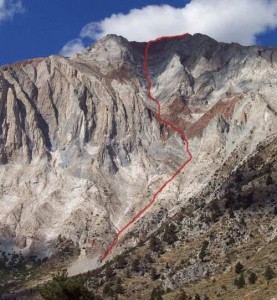
I picked up Peter Croft's book Good Great and Awesome. I am in Mammoth so the choice seemed perfect, 15 minutes from my door, no need for a partner, and a short approach.
After hand splitting 2 truckloads of wood with sore arm and quite tired I got a good nights rest hoping I would be at the trailhead by 9AM
To my surprise I was at the trail head a bit past 8AM, the sun was just starting to come over the ridge.
Visit on photobucket.com
A bit of snow was at the top of the route, but seemed it wouldnt pose too much of a problem.
Let me also tell you I haven't hiked much and haven't really ever done any climb/scramble like this before.
I passed the John Muir wilderness trail and got to a switchback that led off in what I thought was the wrong direction. So I started to head up the by the creek, I saw 2 carins but going was already starting to be a pain, so I headed up the hill some more to find the trail I had just wondered off from. Gotta look at that book again, must have misunderstood the approach description.
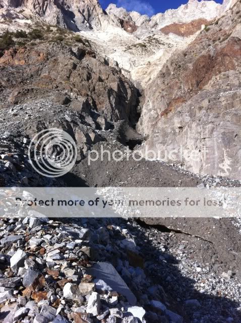
Shortly later I was looking up a drainage with some dirty snow, I knew I was in the right place.
Visit on photobucket.com
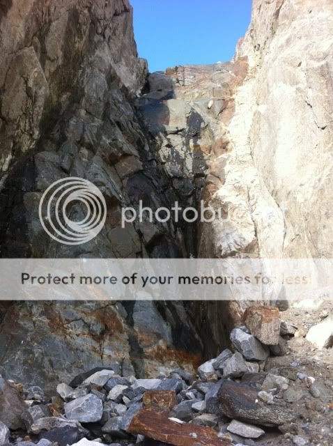
A few minutes later I was over the dirty snow patch and looking up on the first section of "climbing." Dam this looks hard, but mostly because there is a bit of running water and the rock is all wet. I got about 5 feet up and decided to turn around, "there has got to be a way around this," I headed up the loose rock and found what seemed to be a way back into the gully, but I again decided against this, looked a little sketchy. Thinking of turning around I headed up one last part and sure enough found my way into the gully with a bit of easy traversing.
Visit on photobucket.com
I read a few reports and saw most people wore approach shoes or their hiking shoes. I decided to bring my trail runners and my Mad Rock Frenzy (mostly climbing/approach shoes)
The first section was blocked by a chockstone and I got up right to it. There was no way these trail runner were going to work, so I switched to my climbing shoes. I was up and over the stone with a little effort. A few more little steps that looked like they were going to be quite hard from far, but once I got close they were more mellow and lots of features.
About 1.5 hours after starting the route I was right below the red rocks, and it started to sprinkle rain/sleet, I am halfway between moving and didn't really have a light rain jacket and was only wearing a hiking shirt and my Patagonia R1 Hoody. I couldn't decide if the storm in the distance was heading right for me or not. Shortly after the rain died off, but there were plenty of dark clouds in the distance.

Visit on photobucket.com
After the red rocks section you come to the "slabs" which last I would say about 500 feet with plenty of platforms. This was my favorite part, the rock turns from slippery to super grippy almost like sandpaper to average rock, with red veins going through. Also noticed the rock was scarred and scratched from all the falling rock, made some cool patters, it was pretty amazing and fun. By this time you are really in the gully and I couldn't see the upcoming storm.

Visit on photobucket.com
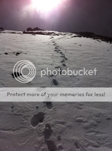
Above the slabs is where I started to hit a bit of snow, no problem at first, but as I climbed higher the gully had more and more snow. I decided to head to the right which I thought would be the summit. I left my climbing shoes on for a while, trying to actually climb rock, instead of through scree. Finally I put my trail runners back on, but the rock was very loose, and the soil under was wet and not supportive. I sent a lot of rock down below.

Visit on photobucket.com

Visit on photobucket.com
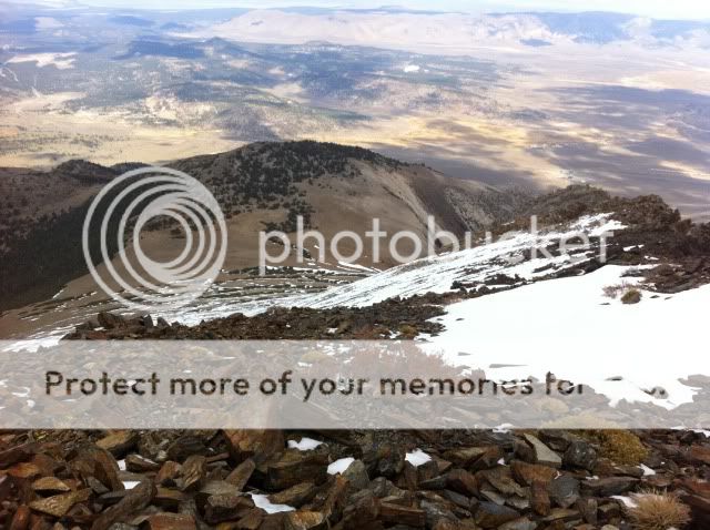
Finally after stomping through a few patches of snow and more loose rock I arrived at what I thought was the summit, and it was the summit! with the USGS marker 5 feet away. Mt Morrison the neighboring peak was covered in clouds, and the wind was picking up. There were also a few snowflakes in the sky. I was pretty tired and didn't see a register or anything. I had some water, gatorade, and a peanut better cup and I was on my way down.
Visit on photobucket.com
Instead of following the rocky loose ridge I headed down the 6-12 inches of snow, as I didn't want to deal with any more loose rock. This in a way was a mistake, because I got a little confused since I dropped low onto the backside. There is a HUGE bowl below which I thought was for the descent, but I wasn't sure so I headed to the ridge, "looks too steep," then I was going to head all the way around this bowl then drop down. I got a few hundred feet and looked back, I saw the ridge continued (I thought it just dropped off.) So I headed back to the ridge. I looked at the book 2 or 3 times and couldn't figure out the topo or the picture in Croft's book.
Visit on photobucket.com
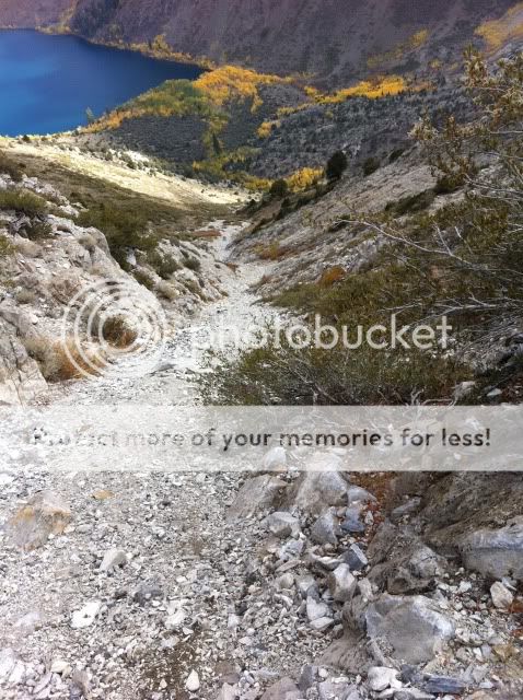
I got further down the ridge and pulled out the book once again, now it was all making sense. I needed to drop down the gully right now. I had a blast scree surfing down all the loose rock. At a few points I was 6 inches deep in the scree. I followed down, through some more solid rock then surfed a bit more. It dumped me out into a creek, nice and rocky.
Visit on photobucket.com
By this point I was tired and just wanted to get down, it was so close but I knew it was going to be work and take a while. For the next 45 minutes or so I wondered through the rocky creekbed and through shrubs, bushes, and more rocks. The last 15 minutes seemed to take forever.
Finally I was back at the trail where i proceded to pretty much run, as I was hungry, tired, and wanted to be back home.

Visit on photobucket.com
Notes/Gear
Trail runners
Mad Rock Frenzy climbing shoes/approach (worked really good)
Patagonia R1 Hoody
Beanie
Trekking Poles (didn't use them on route, but for the descent they were crucial, especially with all the rocks and scree surfing)
2 Liters water, 1/3 liter of gatorade, and some snacks
Helmet
(before/after/and at the summit I was wearing my R1 with the hood on, helmet, and beanie over the helmet and was still a bit cold)