|
Alaska
Climbing Info
Alaska is huge. At over 586,400 square miles it is 1/5 the size
of the entire United States and larger than the next four largest
states combined. It is no surprise that Alaska has one of the greatest
climbing arenas on earth. The Alaska Range is one of the worlds
finest mountain environments and North Americas premier
alpine climbing destination. At 20,320 feet, the continents
highest peak, Denali is the central focus of the range. Because
of the lure of climbing to this lofty point, a network of easy
access has been created to allow climbers to explore the magnificent
peaks surrounding Denali as well. This area, referred to as the
Central Alaska Range, contains some of the biggest, baddest, and
steepest peaks to be found anywhere. Expert climbers from around
the world come here year after year to put their skills to the
test. But the range is certainly not limited to the elite. An array
of easier peaks and back-side routes makes it just
as appealing to novice and intermediate climbers. Climbing amongst
the splendor of these mountains is a delight for all.
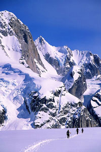
The mountains of the Central Alaska Range contain incredibly diverse types
of climbing all in a relatively close area. On the same day only 15 miles apart,
climbers in the Ruth Gorge may be cruising up 10-pitch rock routes in short
sleeves, while climbers high on Denali may be struggling up difficult ice and
mixed terrain in desperate conditions. In these mountains there is something
for everyone: high-altitude mountaineering, technical ice and mixed climbing,
big wall climbing, alpine rock climbing, cragging, and ski touring. It is common
for climbers to show up on the glacier with rock shoes and a chalk bag in addition
to their ice tools and ice screws.
While it is true that the Alaska Range has a reputation for having poor weather
and brutal storms, when the weather is good, the rewards of being here are
immeasurable. The expansive glaciers, rugged summits, and pristine ridge lines
will forever be impressed in your memory. And the huge Alaskan scale of these
mountains continually astounds all that visit.
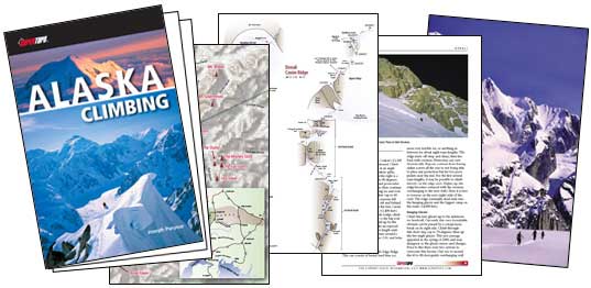
Brief ad break: please help support this site by checking out
the Alaska
Climbing guidebook. There is a free
sample dowload here
Getting
There
Anchorage
The path to climbing in Alaska has changed immensely since the
days of Belmore Browne who mushed dogs from Seward to reach the
Muldrow Glacier months later. These days simply hop on a jet-liner
to the booming metropolis of Anchorage, Alaska. A few adventuresome
folk prefer to drive to Alaska each season. Pick up The Milepost magazine
for the best driving beta available.
If youve purchased all of your food prior to the trip and do not need
anything in Anchorage, it is possible to have a shuttle van pick
you up at the airport and deliver you directly to Talkeetna. Make
sure your flight schedule matches your shuttle companys pick-up schedule. The
driver may be able to make a few short stops, but this should be arranged with
the company in advance.
Another option is to take the Alaska Railway directly
to Talkeetna or Denali Park. The train is definitely a pricey option,
but it is a neat way to experience Alaska. Although the train goes
directly to the Anchorage International Airport, this service is
reserved for tourist groups only. To catch the train it is necessary
to travel 20 minutes by bus or taxi to the Anchorage Depot. The People Mover bus
is a good way to get around town.
With airline baggage limits so restrictive these days, many climbers
(especially international climbers) find it easier to take a day
in Anchorage to complete their expedition food and gear shopping
before heading up to Talkeetna. A good option is to rent a car
at the airport for a day and complete all your necessary shopping,
then have the shuttle service come and pick you up. An overnight stay at one of the youth or climbing hostels can also be arranged. Check out Earth Bed and Breakfast for the best climber friendly accommodations. Lori and Angel go out of their way to welcome climbers from all over the world.
While there are numerous locations to get supplies around Anchorage,
the following combination of businesses will carry everything you need
for an Alaskan expedition.
Costco: $45 membership required. Good cheap source for
staple foods needed in large quantities. Bulk batteries and cheap calling
cards also available.
Fred Meyer: General grocery outlet and multi-department
store. The Brown Jug liquor store is attached as well as a bank and ATM.
Natural Pantry: Health food and bulk food store.
New Seguya: Excellent source for specialty and gourmet
foods.
Alaska Mountaineering and Hiking (AMH): Local dealer of
climbing and outdoor gear and clothing.
Recreational Equipment Incorporated (REI): Climbing and
outdoor gear and clothing.
If in search of some good food and entertainment in Anchorage, stop by
either the Mooses Tooth Pub and Pizzeria or the Bear
Tooth Theatrepub & Grill. Both are fun and popular spots with
great food and variety. Also the Middle Way Café (right
next to REI) and the Organic Oasis both serve excellent
vegetarian and vegan cuisine.
Talkeetna
From Anchorage, follow Alaska Highway 1 north 35 miles to the junction of Highway
3 just east of the town of Wasilla. Turn on Highway 3 north (the George Parks
Highway) and follow it another 64 miles to the Talkeetna Spur Road junction.
Take a right and follow the Spur Road 14 more miles to Talkeetna. The drive
takes about 2.5 hours. Talkeetna is a wonderful little community with a rich
Alaskan history. Originally a railroad supply depot on the way to gold mining
claims farther north, the Talkeetna townsite was established in 1919. The
economy nowadays is largely tourist driven with many activities such as fishing,
hunting, river-rafting, flight-seeing, and of course mountaineering. Talkeetna
is a Den’aina Indian word meaning “place where food is stored
by the river”, or more poetically translated, “river of plenty”.
Once in Talkeetna, there are a few more businesses for last minute
shopping. Prices in Talkeetna are generally higher but supporting
the local businesses helps the local small-town economy. Two
very small grocery stores and a health food store may have some
last minute goodies, but dont count on being
able to buy food for a three week expedition. Climbing gear stores come and
go in town, so its best to check with your air service beforehand to
see what the current situation is. Some of the air services may have some gear
for sale or for rent as well. White gas or Coleman fuel can be purchased from
the air services.
For eats, the Talkeetna Roadhouse is by far the best bet for
breakfast, and they also serve fresh pastries, homemade soup, and sandwiches
for lunch. Bring your laptop for a free wireless connection. They also offer coin-op laundry and public showers. Mountain
High Pizza Pie serves gourmet pizzas and calzones. The West
Rib Pub and Grill is a favorite climbers hangout, with great
beer and burgers. Sparkys is the old standby for a
variety of take-out meals. The Latitude 62 is a nice alternative
for breakfast, lunch, and dinner.
After dinner, the historic Fairview Inn is the local drinking
establishment, often featuring live music. The West Rib is also a great place to tie one on after (or
before) a hard climb.
For overnight accommodations, check with your air service to see if they have
a bunk-house or other lodging facility. Often, climbers are allowed to camp
on the air service grounds, but be sure to check with your company beforehand.
The Talkeetna Hostel International is located near the airport
and is a good deal for climbers. The Talkeetna Roadhouse has
convenient and comfortable rooms. The Fairview offers nice
rooms, but can be very loud at night. The Swiss Alaska Inn and
the Latitude 62 also have rooms.
There is a bank located at the Talkeetna Spur Road junction (The Y).
There are no banks in Talkeetna, but there is currently at least one local
ATM. Laundry can be done at Tanners Trading Post. Public
showers can be found here as well. A small public library offers free internet
access. Several other establishments around town offer internet for a fee.
Some air services offer internet access for their customers.
Other local attractions include the Talkeetna Historical Society Museum, which
features an intriguing 12-by-12-foot raised relief wood model based on Bradford
Washburns Mt. McKinley map. The Talkeetna Cemetery has a climbers
memorial as a tribute to all that have died while in the Alaska Range. The Talkeetna
Ranger Station is the single largest source of Alaska Range climbing
information with their somewhat organized binders with route info and pictures.
To really get your blood pumping, several gigantic Washburn photographs line
their walls. An excellent indoor climbing wall can be found at the Alaska
Mountaineering School. For a great view of the Alaska Range, follow
Main Street west out to the river.
The
National Park Service
All of the climbs in this book are located within Denali National Park. The
Mt. McKinley National Park was created on February 26, 1917 for the protection
and preservation of this unique natural resource. In 1980, the original park
was designated a wilderness area and the much larger Denali National Park
and Preserve was formed. Currently, all climbers attempting to climb Denali
and Mount Foraker must pre-register with the National Park Service and pay
a special use fee. Each member of the team is obligated to visit the Talkeetna
Ranger Station in person at the time of their climb to pay the fee
and have a pre-climb briefing with a climbing ranger. Climbers on other peaks
in the range are encouraged to voluntarily register with the Park Service
at the ranger station. In addition, all users of the park must pay the standard
National Park Entrance fee.
The
Mountains
In Talkeetna there are five licensed air services that can
land climbers and their gear on the glaciers within the National Park. All
of the air services are located at the Talkeetna State Airport east of town,
although several of them have offices downtown. The air services use ski-wheel
aircraft that can land and take off on both pavement and snow by protracting
and retracting large skis. These small airplanes typically hold 3 to 5 climbers
and their gear, although larger aircraft being used can hold over 10 people.
Contact your chosen air services well in advance of your trip for more information
and reservations. Glacier landing locations and information is given at the
beginning of each climbing area section. Air services may be able to shuttle
parties between climbing areas. Check with your air service for availability.
The North Side routes are not accessible by airplane and must all be approached
overland.
Seasons
and Weather
The Central Alaska Range is the middle section of a great 500-mile arc of mountains
that sweeps across southern Alaska. The mountains sit unobstructed some 130
miles from Cook Inlet and about 430 miles from the Bering Sea, where weather
systems form. It’s no wonder that the range gets some of the biggest
and most feared storms on the planet. Combined with its proximity to the
ocean, the huge uplift off the lowlands is a major factor to the brutalness
of the weather. The mountains rise steeply from the 1,000-foot elevation
lowlands on the south and the 2,000-foot tundra on the north. Denali itself
has an abrupt uplift of about 15,000 feet from the head of the Ruth and Peters
Glaciers.
The Central Alaska Range mountains are also sub-arctic. Denali is located at
63° 04’ 10.5” latitude; 35-degress or 2,400 miles farther north
than Mount Everest. This attributes to not only much colder temperatures than
more equatorial ranges, but also a thinner atmosphere and lower pressures.
Twenty thousand feet on Denali feels much higher and colder than 20,000 feet
in the Himalaya or Andes.
It should be noted that the range creates a rain-shadow effect to its north
side. Talkeetna, 60 miles south of Denali, averages 30-35 inches of rainfall
per year. Lake Minchumina, 60 miles north of Denali, averages just 12 inches
of rainfall per year. The north side glaciers and tundra generally receive
much less snowfall and it tends to be drier and the snow less consolidated
in the early season.
Planning
The overall climbing season in Alaska is March through September, with most
ascents occurring in May and June. Winter and off-season ascents are rare
but not unheard of. In general there is not a particular month that has better
weather than others. There is no discernable difference between the average
number of good climbing days in March, April, May, June, or July. People
try to predict monthly trends in the weather but every year is different.
So how does this help? Instead of planning your trip around when you think
the weather is best, plan your trip on when the temperatures are best for
your climbing objective.
For Denali, it is no secret that the highest success rate is in
June. This is a result of warmer temperatures rather than better
weather. April and May can provide for great experiences on Denali,
with fewer crowds, cleaner snow, and a generally more pristine
environment, but chances of success go down because of the extreme
cold at altitude. There have been years where there have been no
summits in May until the last two days. July certainly has warm
weather but the glaciers become so broken up that traveling on
and even landing on the Kahiltna becomes problematic.
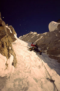
On the other hand, April and May are generally the best time to do the
lower elevation technical snow and ice routes, such as Ham and Eggs, Mount
Dan Beard, Kahiltna Queen, and Mount Hunter’s North Buttress. These routes typically
fall apart and become very dangerous by June. Snow mushroom and cornice collapses
are a clear and present danger. In general, early season ascents may have unconsolidated
snow, more snow over rock, and brittle ice. As the season progresses, snow
and ice conditions generally improve but natural rock and icefall become a
problem.
Another consideration when planning a trip is the available amount of light
versus dark. The joys of climbing in Alaska come when you are able to climb
at all hours of the day and night without a headlamp. This usually comes
in early May for non-technical snow routes where there is enough radiant
light from the snow. By late May it becomes possible to climb technical
routes and see to place gear at the darkest hours.
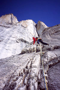
For rock routes in the Ruth Gorge and Little Switzerland, the season typically
starts early June when temperatures have warmed up enough to melt much of
the seasonal snow off the rock and it is light and warm enough to climb
24 hours a day.
Match your objectives within the suitable time frame. Your best bet is
to come with lots of time and lots of objectives. Be prepared to take whatever
the weather dishes out. Remember, storms create the unique environment
in which we climb.
Predicting
There are a few key weather observations that will help in predicting and preparing
for storms and climbing days. The following are the typical storm events
and weather systems that occur in the range.
General Storms:
Southwesters:
The typical storm starts in the western Aleutian Islands and tracks up the
south side of the islands into the Gulf of Alaska. These storms tend to give
at least 12 hours of warning, first by a sequence of high cirrus clouds approaching
from the southwest. Winds increase and the sky will often turn a solid white
color with a prominent ring around the sun. Eventually cumulus clouds will
form and precipitation is imminent. One of the major warning signs of bad weather
in general is a warming in temperature. These storms characteristically last
about four days.
Bering Storms:
These storms originate in the Bering Sea to the west and are pushed north of
the Aleutian Islands by high barometric pressure over Hawaii. They can be the
fastest and most violent of all storms. Black clouds quickly appear due west,
and it may be snowing within four hours. Although not always fast and terrible,
a few of these have been the worst storms I’ve ever experienced, with
up to eight feet of snow within 36 hours and sustained winds of 60+ miles per
hour. The longest of these storms can last up to eight days.
The Eastern Flow:
The bane of the technical climbers wanting to get on a hard route, this weather
pattern is the hardest to come to grips with. The forecast will generally
call for precipitation everyday, and evil looking clouds will be constantly
streaming in from the east, but long dry periods occur. The weather is never
really stable, but is never usually violent either. Lenticular clouds will
form and dissipate frequently. There normally will be long enough weather
breaks to summit Denali or sneak up the Mini-Moonflower, but climbers waiting
for that perfect forecast to get on the Infinite Spur or Hunter’s North
Buttress will be sitting in base camp, watching much good weather go to waste.
This weather pattern can last from one to three weeks.
North Flow:
If there is to be a flow of weather, the best is from the north. An arctic
high that forms north of the range brings very cold temperatures but generally
clear weather. Conditions up high can be extremely windy and frigid for the
first couple of days. Look for plumes of snow blowing off the high peaks
from the north to signify a possible couple days of clear weather. If the
plumes change direction, watch out for a southwesterly.
High Pressure:
A high pressure system in the Gulf of Alaska and/or the Bering Sea generally
brings clear weather and moderate temperatures. It lasts from one day to
a week or more. Long weather windows also tend to occur when high pressure
develops over the western Yukon or northeast and north central Alaska, holding
back moisture from the sea.
The big peaks and localized storms:
Mount Hunter, Mount Foraker, Denali, and occasionally some of
the smaller peaks, suffer from the infamous lenticular cloud cap formation.
These airfoil-like clouds are created by the mountain itself and the prevailing
winds aloft. The air around a mountain tends to be warmer than the mountain.
Depending on its humidity or moistness, as winds collide with this air
mass, it forces it over and around the mountain to create a lenticular
cloud. It can be completely clear and cloudless everywhere else, except
for this cloud. These clouds can form and dissipate within minutes and
can be either quite violent or mild. Whiteout conditions normally exist
within the cloud, and precipitation and winds can be intense. The caps
usually form during the day but disappear in the evening when the air temperature
around the mountain cools down.
Climbing (using the weather to your advantage)
The weather is by far the most talked about subject when climbing in the Alaska
Range. Dont always trust the forecast given to you. It may be valuable
for predicting general weather trends, but on a day-to-day basis it can be
unreliable. This really comes in to play when climbing the smaller peaks
in the range, or when making the summit push on a big route.
For the smaller peaks, the unpredictableness of the weather means that the
climber must always be ready. Even though the forecast may call for snow the
next four days, there just may be a 12-16 hour window of opportunity in there
somewhere. This may be your one shot at the Southwest Ridge of Frances or Shaken,
Not Stirred. (Remember to allow for snow conditions to settle out after a big
dump.) Have your gear packed and check the weather, especially at night. For
rock climbing in the summer, a weather window may come in the middle of the
night.
For the larger less technical routes on Denali and Foraker, it is best to try
and move on the lower sections of the route in periods of marginal to bad weather.
Do not wait for perfect weather all the time or you will not get very far.
Work on maneuvering your team into the highest possible position, then wait
for the good weather to make a summit bid. On the flip side, dont push
too high in bad weather or you may become demoralized and destroyed and at
the first sign of good weather, you may find yourself going down. For big long
routes such as the Cassin or the West Ridge of Hunter, climbers generally wait
and sit tight for a big high-pressure system to be forecasted, and then move
as fast as possible to utilize it.
Also be sure to consider and prepare for the range of temperatures that will
be encountered. It can be downright broiling on the Kahiltna Glacier or in
the Ruth Amphitheater in mid-June on a sunny calm day. During hot days down
low, the best strategy is to move during the cooler nights and sleep during
the day. This assures better snow conditions, safer crevasse crossings, and
less risk of heat related illnesses. As you ascend higher in elevation, the
schedule will eventually be reversed as nighttime temperatures become frigid.
Equipment
This book covers a wide selection of climbs and types of climbing. Packing gear for a three-week trip up the West Buttress in May will be substantially different than a one-week trip to Little Switzerland in July. Alaska in general requires high-quality pre-tested gear to combat the extreme winter conditions, temperatures, and winds. For late spring and summer ascents on snow and ice routes in Alaska, come prepared as if you were going to make a foul-weather winter ascent of Mount Rainier or an extended winter climb in the
Canadian Rockies. Earlier season climbs in Alaska require an extra
level of preparedness. For technical rock routes later in the season,
come prepared at base camp for cold weather, but the gear taken
on the climbs can be tailored to the current temperature and weather. A few equipment suggestions can be found below.
Glacier Travel:
Every route in this book requires climbers to carry standard
glacier travel and crevasse rescue gear and be proficient at using it.
Travel on Alaskan glaciers can be much more serious than on lower-48
glaciers and elsewhere around the world. High winds and heavy snowfall
allow gigantic crevasses to be bridged with thin layers of snow. This
combined with a lack of the freeze-thaw cycle makes these unconsolidated
snow bridges exceptionally dangerous. With the increased scale of the
glaciers comes increased crevasse sizes. It is not uncommon for crevasse
bridges to be 30 feet wide or more.
Either skis or snowshoes are obligatory. Skis are by far the safest and
fastest means of glacier travel, but they can be difficult to use when
roped up and handling a sled. It is best if each member of the rope team
uses the same method of travel. Plastic sleds are commonly used to haul
gear around. Its
helpful to practice rigging and dragging a sled before arriving on an Alaskan
glacier. Sleds are generally provided for free by your air service.
Boots:
For all of the snow and ice routes in this book it is
recommended to use expedition-style plastic
double-boots with warm
high-altitude liners. For elevations higher than 14,000 feet or
for early season climbs, fully insulated overboots should be available
for use. Footwear is a bigger concern for climbers on technical
routes. Overboots can make rock and mixed climbing difficult. Test
your footwear thoroughly before getting on a big climb. For a route
like the Cassin in June, I find I can get by with just good plastic
boots and supergaiters. Luckily on this route, the more technical
climbing ends at 16,700 feet. If you need to take overboots with
you, they can be donned here for the summit bid. Make sure you
can easily adjust your crampons to fit with or without your overboots.
For the summer rock climbing areas such as the Ruth Gorge and Little Switzerland,
insulated leather
boots are generally sufficient to get around on the glaciers
and are easier to take up routes. Depending on the temperatures, rock shoes
may need to be able to accommodate socks.
Clothing:
For non-technical routes, a standard layering system works fine. Bring a high-quality
down parka with attached hood. Water-proof breathable shell fabrics are great
for cutting out the wind and snow. For technical routes, I prefer the layer-over-the-top
system. Over your synthetic base layer, a micro-fiber shell is worn. When conditions
worsen, insulated synthetic layers are put on over existing layers. With this
method it is much easier to regulate body temperature and your clothing tends
to fit better and stay drier.
Sleeping Gear:
For routes up the big peaks and base camps, a sleeping bag rated to -20 to
-30-degrees is necessary. Sleeping bag ratings are highly subjective. Ask around
and test your bag out to make sure it is right for you. Most people use down
bags which are lighter and more compressible but require more care and effort
to keep dry. A -30-degree synthetic
bag is just plain huge, but it will always
keep you warm. Make sure it is roomy enough to accommodate boot liners, water
bottles, camera, sunscreen, etc.
Two full-length sleeping pads are a necessity. Be aware that the inflatable
type can be prone to popping, rendering them practically useless.
For more technical routes on smaller peaks, live by the adage “light
is right.” I often use a 10 to 20-degree down bag. If I get cold, extra
clothes and a hot water bottle help me through the night. To keep the pack
size small, sleep on only one sleeping pad, often cut small, in addition to
your pack, ropes, and other items.
Rock climbing rack:
Here's the rack we at SuperTopo bring when we climb in Alaska.
This is just to give you a general idea of what to bring. Check
to the SuperTopo
guidebook before climbing each route to see specifically what you need.
1-2
sets of BD
stoppers
2 sets of Metolius
Master Cams to #5
2 sets of Black Diamond Camalots
#0.5-3
1 60m lead
rope or two 60m double ropes
BD
Oz quickdraws and 20 extra lightweight
biners
10 shoulder length
slings
climbing harness
Petzl Reverso 4 belay
device
free climbing
shoes
Meteor or Half
Dome helmet
single
gear sling
Group Gear:
Tent:
A strong four-season
dome tent for two or three people should be used for base
camps and all non-technical snow and ice routes. A floorless circus-style tent
makes a great cooking shelter. For technical routes requiring an overnight
camp, a small foot-print single-wall
tent is best. If just out a single night
and the weather is good, a bivy sack may be adequate.
Shovels:
Leave your plastic shovels at home. A sturdy aluminum
shovel with a flat blade
is the best for all-around use and building snow structures. A steel pointy
garden blade can be useful for breaking up ice layers at the higher camps.
Bring at least two shovels per tent. At least one snow saw is also a handy
addition for building snow walls and igloos.
Stove:
A good, field-tested stove is mandatory. Your stove is your life. I recommend
using a white gas model over a fuel canister model. They melt water faster,
create less waste, and work better in the cold. White gas (Coleman fuel) is
widely available and used in Alaska and on the glaciers. The MSR XGK model
is an excellent all-around choice. Be sure to bring a good stove board to insulate
the stove from the snow.
Fuel:
White gas fuel can be purchased at any department, hardware, or climbing store.
Other forms of fuel, such as propane or butane canisters, are available at
most of the climbing shops. Each season white gas is flown up separately to
Kahiltna Base Camp by the air services. Climbers going here must buy their
fuel from the air service in Talkeetna and acquire it at Base Camp. For other
landing areas or if using canisters, check with your air service for current
regulations for flying with fuel. Fuel canisters generally have tighter government
restrictions and are more difficult to fly with.
Bring a minimum 8 oz. of white gas per person per day. White gas is typically
sold by the gallon. This comes out to 16 person-days per gallon. A two-person
West Buttress trip would do well with 2.5 to 3 gallons. When traveling by plane
to Alaska with fuel bottles, separate the pumps or lids, rinse out the bottles,
and put them in a stuff-sack with the lid off.
Communication
Citizen Band (CB) radios:
CBs have limited functionality throughout the range, except in the Kahiltna
Glacier area where they are commonly used. They provide only line of sight
transmissions. Channel 19 is the most commonly used frequency and Channel 7
on the north side of the range. Airplanes generally do not monitor either frequency.
Several air services will rent a CB radio or you can buy one for about $65
at an electronics or large multi-department store. Check with your air service
for availability. Be sure to keep the batteries warm and carry a spare set.
Aircraft radios:
Although a federal license is technically required to use one, these
are far more reliable than CB radios, allowing you to communicate directly
with pilots. Aircraft radios should only be used in emergency situations
or when scheduling a pick-up. They should not be used to check the weather
or talk to other climbers. You will be talking on the same frequency the
pilots use to relay their positions to other planes. Interfering with this
vital communication, compromises their safety. Check with your air service
for rental availability.
Cell Phones:
Cell phones have limited functionality with spotty coverage in the
Alaska Range. They generally work above 14,000 feet on the south side of
Denali or Foraker, and from the summits of more southern peaks that are closer
to the road system. Do not rely on your cell phone for your only means of
communication.
Satellite phones:
Sat. phones have slowly been decreasing in size and price over the
years. This is by far the most reliable and useful form of communication
in any remote region. Satellite phones can be rented from Globalstar Satellite Phones: 866.282.1048. |