jhodzic
Sport climber
Davis
|
 |
Does anyone know what the conditions are now? I'm looking to climb it this weekend.
Thanks,
Jasna
|
yosguns
climber
|
|
I just want to make sure people interpret what I wrote the way I meant it: We didn't witness any actively falling rocks when we were in the basin, on the pass, or on the ridge the last weekend in May. We did see evidence of past rockfall in the area.
If I had to make a judgment about whether the evidence suggested more than a usual amount of rockfall for greater Yosemite, I would say that it does. There were a couple talus slides that reminded me of the area near the GPA rockfall. I can't make a judgment as to when this rockfall occurred, though, or if the area is more unstable now than some recent time before. Therefore, I don't know how valuable this information is because I haven't seen descriptions of the area remarking inordinate instability and I'm pretty sure those descriptions were based on similar experiences to mine, meaning the area is not unstable enough to warrant avoiding it or mentioning it. I recognize, however, that this was my first time there, so I have no personal reference point rendering all this merely an exercise in conjecture.
I'd be interested to know about the history of rockfall in the area though. Does anyone have a lot of experience up there? Yosemite 5.9, have you been up there a lot?
|
yosemite 5.9
climber
santa cruz
|
|
The rock fall was all over. There are very large talus fields at about 9,500 feet along Horse Creek that had a rock fall. There was rock fall on the right from the three red cliff faces as you approach the pass. There was rock fall near our camp above Horse Creek at about 9,500 feet. This was on the opposite side of the large talus mentioned above. There was evidence of rock fall in the snow in other areas.
The rock in this area is not generally granite. It is deteriorating sedimentary rock as far as I know. The talus fields are very large.
I have heard rock fall in Yosemite at night a few times. There are areas in Yosemite Valley that have had significant rock fall in the thirty years I have visited there. Guides have warned me to not climb in certain areas that once were popular. Glacier Point Apron had tremendous rock fall a few years ago.
My current guide and my neighbor who worked with Peregrine Falcons on El Cap have both experienced near hits from rock fall on El Cap.
My point is that granite is dangerous enough. I don't need to go looking for worse rock. But to each his own.
|
yosguns
climber
|
|
We went up to the summit ridge via SW slope from Horse Creek Pass the week after Yosemite 5.9's trip and didn't hear/see any rock fall, though on the pass, on the western slope (to the right if you're going over the pass from Horse Creek basin) there was evidence of an avalanche in the snow.
We had a really nice time. The sketchiest part in the pass was a snow ramp across the eastern slope with a tiny bit of steep (almost) water ice below it. We were with friends with no experience, but they managed to make it across early in the morning with crampons and axes. I'm sure that by now this all looks different because some snow has melted out. The snow in the afternoon was too soft to go back across this ramp and we went down and up on the western side of the pass, which was much safer and easier.
Lots of snow on the summit ridge and a very cool view down East Couloir(?). It was my first time up there and I can't wait to go back for a more technical route up to the summit.
|
splitclimber
climber
Sonoma County
|
|
So to clarify, the bad rock is on the decent/over by Horse Creek Pass?
Yeah, I've watched rock fall up on the loose slope on the right as you get to the pass when ski touring out there.
|
yosemite 5.9
climber
santa cruz
|
|
the snow started at 9,000 feet. We had to turn back at 10,600 feet on Memorial Day, 2015. Stomping with crampons and being off route blew it for us. We were just trying to hike up the back side.
The Horse Creek valley has a lot of rock fall. We heard rock fall at least three times a day for two days and saw some of it. The rock in this area is deteriorating fast. One fall was within a few hundred yards of our camp at about 9,500 feet. I don't plan to go back.
The peaks were covered in clouds, hindering our route finding. Take a photo of the mountain with you. They all look alike. You can waste a lot time trying to figure out which way to go. There are many sources that say route finding is difficult. I thought they were referring to the trail along the creek. It is easy to take the wrong valley to the right of Horse Creek. This is really where the route finding is difficult. The trail along the creek is fine. But beyond it in the snow we were on our own.
If you see our foot prints and the party ahead of us's ski tracks in the Horse Creek basin, don't follow them too far. We missed the right turn to the pass. We did not use the mountaineers route. I don't know that I would want to use the mountaineers route with the rock fall. We tried to go to the pass to hike up the back side. If you want to hike up the back side via the pass, as you look for the proper valley to approach the pass, there are about three large cliff faces with upturned red layers of sedimentary rock on your right side of the valley to hike to the pass. the cliff face on the right has vertical layers. the one in the middle has angled layers. the one on the left not so much.
It was all beautiful in the snow. The weather was rainy and snowy. I loved every minute. But the rock fall concerns me too much to go back.
|
bergbryce
climber
East Bay, CA
|
|
Climbed this yesterday.
Believe it or not, May was a wet month in much of the high Sierra and there is a fair amount of snow above the incredible bivy site below Matterhorn Peak. The snow was mostly firm on the approach, but it's not exactly freezing hard overnight. The descent was ~2,500' of boot to thigh deep plunge stepping. A bit of a slog. Chilly on the belays too.
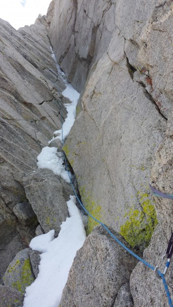
The crux pitch also had ice in it which made for an exciting finish.
|
Stevee B
Trad climber
Oakland, CA
|
|
Climbed 6/28/14. Some firm snow in sections still, depending on weather. Humping crampons and an axe may be less arduous than trying to link the dry boulders and weaving the talus and scree. Descending from E. Couloir required hugging the base and some ledgy loose 4th classing to avoid the snow.
Saw two pairs of shiny bolts & rings, one below and to the left of the top of pitch 3, and another out to the left of the top of pitch 4. Anyone know the story? My guess is they were for a rescue or recovery.
|
timbok
Trad climber
oakland ca
|
|
Climbed two days ago. Snow towards the top approach had warmed by the time sun hit it (around 8ish) and fine in approach shoes.
As others have said, plenty of loose rock towards the bottom and not much exposure. At the top of the 4th or so pitch we moved right on the big ledge to climb the last two pitches of the Double Dihedral route, which we thought were better than anything on the north arete. The top dihedral pitch was great, with great stemming and mantle moves. We didn't use any wide gear, just small offset nuts and hand size cams.
Great to climb part of a route without a detailed topo to rely on...!
|
Some Random Guy
climber
|
|
yeah moynier and fiddler are all wrong.......as are a lot of the falcon guide descriptions. i think they write all those books from memory of climbs they did 20 years ago.
i quite easily found the start by bringing this pic with me. (credit rhyang) when you go up the east couloir look for the loose ramp with the vertical wall of 5.10ish cracks in the background. the obvious ramp goes up to a notch left of the wall that you can see from in the couloir. hope this helps.......
|
Scoop
Mountain climber
Truckee, CA
|
|
Maybe I am an idiot, but I tried three ways and could not for the life of me find the start to this route. Whatever way I went -- and there are not a lot of choices in the gully -- it was sure as heck was harder than 5.7.
Just sayin'
|
Vitaliy M.
Mountain climber
San Francisco
|
|
Does one need crampons to approach the route at the moment?
|
Doug Robinson
Trad climber
Santa Cruz
|
|
I did it in January years ago. Or rather I climbed the NE couloir, to the right of the rock.
It was Butt Cold! The Bridgeport valley is often the coldest spot in California. We skied up (check the avy forecast) and had to keep taking our boots off to warm up our feet on each others' bellies.
Snow climbing the gully was plenty exciting. I would think the Arete would be basically too cold to free climb in January.
|
schaffner
Trad climber
|
|
Does anybody have information on how this climb would be in January?
Edit: We climbed the E couloir on January 16th with crampons (almost not necessary). The N Arete looked mostly clear of snow and it was pretty warm (like 40+ F), it probably would have been possible to climb it.
|
clustiere
Trad climber
berkeley ca
|
|
I have heard that the double dihedral is quite good if not better.
|
Chris McNamara
SuperTopo staff member

|
|
Here is another trip report with photos
http://www.supertopo.com/climbing/thread.html?topic_id=658617
|
Chris McNamara
SuperTopo staff member
|
|
cool photo trip report
http://www.supertopo.com/climbing/thread.html?topic_id=594724
|
drc
Trad climber
Durham, NC
|
|
I climbed in late June 3 summers ago. Mountaneering boots but no crampons, and just a sharpened stick instead of an axe. The slope on the snowfield is pretty mellow.
|
Jesse Hull
Trad climber
SF, CA
|
|
Anyone know if you need crampons and an ice axe for this route? We are heading here over July 4th. How much snow should we expected?
Jesse
|
Chris McNamara
SuperTopo staff member
|
|
i got this feedback from a user:
Degrees and Decimal Minutes, which has a triple diget last number like the coordinates in the book. I typed in these waypoints on a national geographic topo program and after reading the description and looking at where the program plotted the points they do make sense and most look correct. The only waypoint that looks way off is the Base of Route coordinate. Also the coordinates that are written in the book are written as degrees minutes seconds and the coordinates are actually degrees decimal minutes.
yes,
 the BASE route coordinate is totally wrong. ignore it. the BASE route coordinate is totally wrong. ignore it.
i need to fix the way i describe the coordinate (see above)
|
dufas
Trad climber
CA/NV
|
|
N. Arete is a fun romp. Anyone done the double dihedral route? is this good route to have a strong beginner mountaineer follow?
|
Nix
Trad climber
Berkeley, CA
|
|
Not to plug too hard for SuperTocos but I wish I had this topo when we attempted the North Arete two weekends ago. We were using Moynier's Falcon guide "Climbing California's High Sierra." The route description was a little confusing so we followed the two detailed pictures to the start of the route. Ya right! Dead verticle choss, on an uprotected 100ft leftward traverse, 5.8?, no thanks. A sketchy retreat cost us a nut/beaner/cordollete and two of our nine lives. Some say that a picture is worth a thousand words. In this case it was a thousand expletives. After collecting more beta (ie SuperTopos and the Secor book) it turns out that both Moynier pictures are dead wrong! They send you up the opposite (West) side of the mountain! Ugg...
|
|
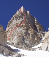
The route as seen from the approach.Photo: Brad Goya
|
*What is "Route Beta"?
It's climber slang for information or tips on a route as in, "what's
the beta on that route?" As a service to fellow climbers we ask SuperTopo
guidebook users to post tips and updates to this website if they have relevant
information to share after a climb.
| | | | | | | | | | | | | | | | | | | | | | |