Trip Report
A bit of water ice on Mt. Morrison on June 8, 2011
|
Tuesday June 14, 2011 6:08pm
|
|
Water ice was recently spotted and climbed for the first time in years in the Mendenhall Couloir (also called the Northwest Couloir, Y Couloir, and other names) on Mount Morrison. I was in luck and was able to get to it just before summer weather took its toll on the ice and snow.
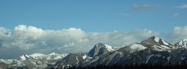
Like many others, I have been impressed by views of Mt. Morrison (~12,241') when I've driven past it on 395. It just begs to be climbed, but virtually everything I have read and heard made the rock routes on its north side sound ominous ("The Eiger of the Sierra"). None of my regular partners could be talked onto it... With so many peaks and routes to climb in the Sierra, Mt. Morrison was barely on my list.
That all changed when I saw Gil's Ephemeral Spring post on Supertopo (May 29, 2011). Gil and Allen climbed the couloir on Thursday-May 26th - perhaps the first time the route had been climbed since John Dittli and Andy Selters climbed it in May 1996. (edit: since originally posting this trip report, I learned that The Chief and others also climbed it a couple times between 2000 and this year's freeze)
They had been preceded by John Mendenhall who climbed the couloir in 1931 - he called it class three. Forty years later, Yvon Chouinard, Doug Robinson, and Dennis Henneck found 200' of steep rotten rock blocking their winter access to the couloir. Mendenhall must have been quite bold and had one heck of a large avalanche cone to get past that steep rock. Impressive!
Gil's Ephemeral Spring post and ensuing thread showed the couloir to be in great condition with ice in the key lower section, apparently little rockfall, and "decently stiff snow" above the ice. After Gil and Allen, other teams jumped on it (Frank and partner, PeteC and partner, and Stewart Johnson -- http://www.supertopo.com/climbers-forum/1523768/mt-morrison-couloir-june-7 ).The pics we saw and reports we read looked very promising. (edit: since originally posting this trip report, I learned that we were also preceded by Paul Teare, The Chief, and others)
Fortunately for me and partner, the weather in that part of the Sierra remained chilly with freezing temperatures overnight and cool days. Unseasonably stormy, too. Had just learned from one of my regular partners that he was ill and had to cancel out on his plans to join me, when another lad (who prefers to remain incognito) called to see if I was interested. Well.... heck, YES!
Coordinating our respective family and work schedules, and other commitments with the weather led to our finally heading over on Tuesday-June 7, so we could climb it the next day - one day shy of two weeks since Gil and Allen zipped up the route.
Now some (lots of) pictures...
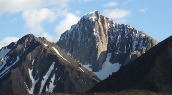
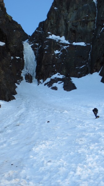
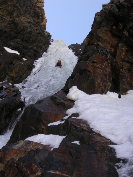
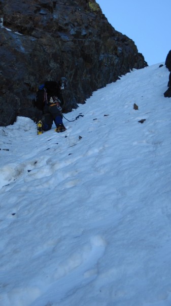
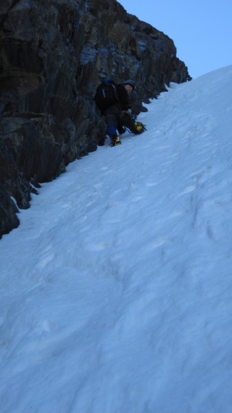
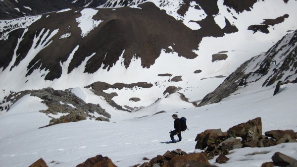
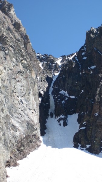
Somewhat closer. The couloir in plain view. The snow leading up to the couloir, the ice, and the snow above the ice look incredibly, wonderfully steep when viewed straight-on, especially when using binoculars. Deceptive.
We drove up to Convict Lake (~7850') to take evening pictures of Mt. Morrison, scope out the approach trail before dark, and snag a campsite before heading over to an Italian restaurant for dinner in Mammoth Lakes. The rain, which we had left farther north in the afternoon, caught us in Mammoth and then followed us back to our camp. The rain finally let up around 10pm and the skies cleared. We did not have a thermometer, but while there was no ice on the bear box at 4am on June 8, there was ice on the picnic table.
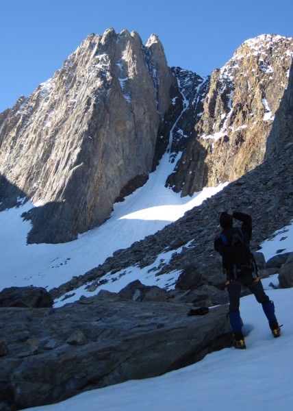
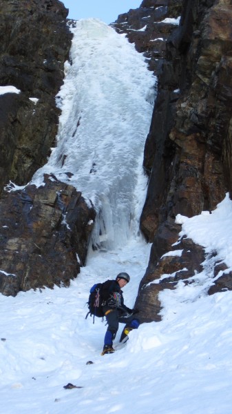
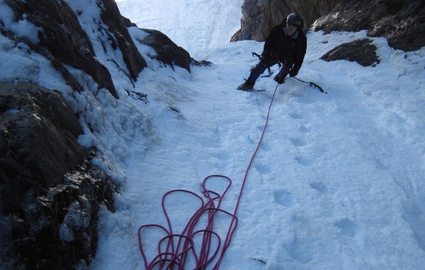
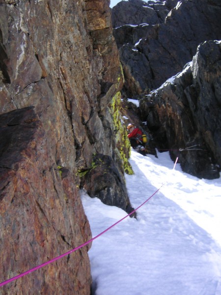
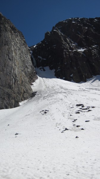
The ice on the bottom right of the couloir appeared to start lower than the ice on the left, and it had an enticingly steep curtain of ice. The left side looked to be more of a steep snow ramp leading up to the ice. We chose the right side and the little curtain (was it 10' tall or taller?).
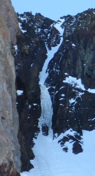
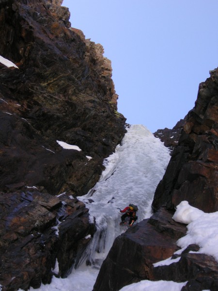
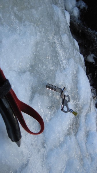
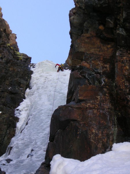
Moving up above the curtain. The ice was soft and plastic with some snow rot and air-filled voids. Excellent ego ice (easy to climb), if dubious protection doesn't bother you. With the camera in telephoto mode, the ice looks somewhat shorter than its almost 60m.
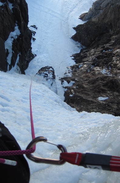
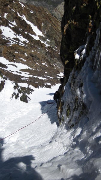
Looking back down. With the 70m rope, my partner was just able to stay around the protective corner of the buttress, until I moved up over the bulge at the top of the ice and onto the snow. Very impressive that, with a bit more snow, John Mendenhall had climbed this eighty years ago!
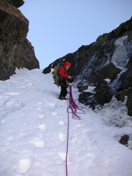
If only the whole couloir had been ice!
 BMcC
BMcC
|
|
About the Author
BMcC is a trad climber from Livermore. |
Comments
JEleazarian
Trad climber
Fresno CA
|
|
|
|
Jun 14, 2011 - 06:16pm PT
|
Thanks for the great TR, and very inviting pictures. Now that real June weather is here, I guess this one needs to wait, but you've added one to my "list."
John
|
|
jfailing
Trad climber
PDX
|
|
|
|
Jun 14, 2011 - 06:30pm PT
|
Rad! Way to get after it!
|
|
le_bruce
climber
Oakland, CA
|
|
|
|
Jun 14, 2011 - 07:26pm PT
|
Real deal, thanks for posting. Don't some call the Morrison NF the Eiger of the Sierra? Maybe I'm botching the memory.
|
|
phylp
Trad climber
Upland, CA
|
|
|
|
Jun 14, 2011 - 09:05pm PT
|
That is a premium trip report. Thanks!
|
|
BMcC
Trad climber
Livermore
|
|
|
Author's Reply
|
Jun 14, 2011 - 11:07pm PT
|
Thanks, all!
We caught the route in nearly perfect condition with fun ice. The snow could have been much firmer, but, hey, I won't complain seriously - it was a great little adventure overall!
A day later would probably have been too late.
le_bruce - the Eiger appellation is noted in both RJ Secor's High Sierra and J Monynier and Claude Fiddler's Sierra Classics. My (most excellent and gracious) partner for this fun couloir climbed the North Face Direct a few years back.
|
|
mike m
Trad climber
black hills
|
|
|
|
Jun 14, 2011 - 11:47pm PT
|
Bump for alpine ice when everyone else is at the beach.
|
|
marv
Mountain climber
Bay Area
|
|
|
|
Jun 14, 2011 - 11:50pm PT
|
Mt Morrison is a "real" mountain in the High Sierra, not to be taken lightly. Well done
|
|
Stewart Johnson
Gym climber
top lake
|
|
|
|
Jun 15, 2011 - 12:05am PT
|
awesome! thanks for the report and a nice way for me to relive the route. great photos.
this was my fifth summit, one would think i could find the
correct descent! cheers stewart
|
|
10b4me
Social climber
Lida Junction
|
|
|
|
Jun 15, 2011 - 12:42am PT
|
sounds like fun
|
|
tuolumne_tradster
Trad climber
Leading Edge of North American Plate
|
|
|
|
Jun 15, 2011 - 12:59am PT
|
another high quality TR Bill
|
|
flakyfoont
Trad climber
carsoncity nv
|
|
|
|
Jun 15, 2011 - 02:22am PT
|
now, thats an adventure !!
|
|
russellg
Sport climber
Malibu, CA
|
|
|
|
Jun 15, 2011 - 02:34am PT
|
Great trip report. I didn't catch how many days it took? Just one?
|
|
ß Î Ø T Ç H
Boulder climber
ne'erdowell
|
|
|
|
Jun 15, 2011 - 02:38am PT
|
That middle spur going to the summit on the NW face looks amazing. Hopefully your report will lure someone onto the rock too.
|
|
nutjob
Sport climber
Almost to Hollywood, Baby!
|
|
|
|
Jun 15, 2011 - 04:50am PT
|
Wow, cool adventure and beautiful pics made Morrison go onto the wishlist! Now if I could only remember what got bumped off the list to make room in my head for this....
|
|
Stewart Johnson
Gym climber
top lake
|
|
|
|
Jun 15, 2011 - 08:56am PT
|
the central spur on mt morrison is 5.10 and called don julie.
|
|
Bad Climber
Trad climber
The Lawless Border Regions
|
|
|
|
Jun 15, 2011 - 10:54am PT
|
Fantastic!
BAd
|
|
BMcC
Trad climber
Livermore
|
|
|
Author's Reply
|
Jun 15, 2011 - 02:32pm PT
|
russellg -
it's a day hike.
We drove over from the SF Bay area last Tuesday (June 7). Climbed and drove home the next day. Convict Lake is only a couple of miles off 395. With the overcast, rainy, snow weather the Convict Lake campground (just before the lake) was uncrowded mid-week.
For Mt. Morrison, you walk around the left side of the lake and then head up. For Laurel Mountain, go around the right side of the lake. The descents are slightly more complicated.
CONDITIONs update from another partner:
"Drove past it yesterday and it was looking pretty grim up there. The upper section had dirt showing. The ice curtain looked pretty sickly too."
|
|
BMcC
Trad climber
Livermore
|
|
|
Author's Reply
|
Jun 15, 2011 - 02:41pm PT
|
Stewart -
Great pic on the Don Julie route.
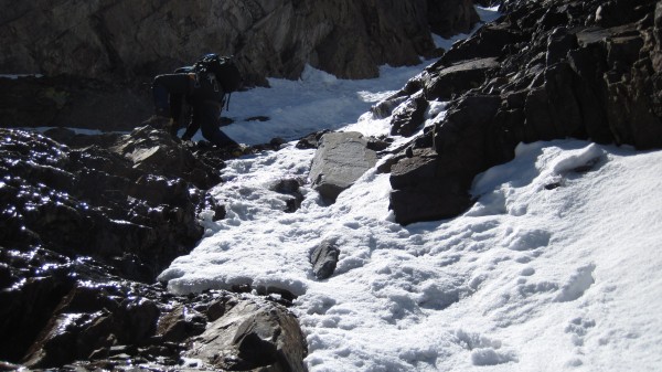
After all that I have heard and read, I was pleasantly surprised to see the rock up close looking as solid as it did. Pretty clean in stretches, too.
Debris? Yep. Nasty looking stuff on ledges? Oh, yes.
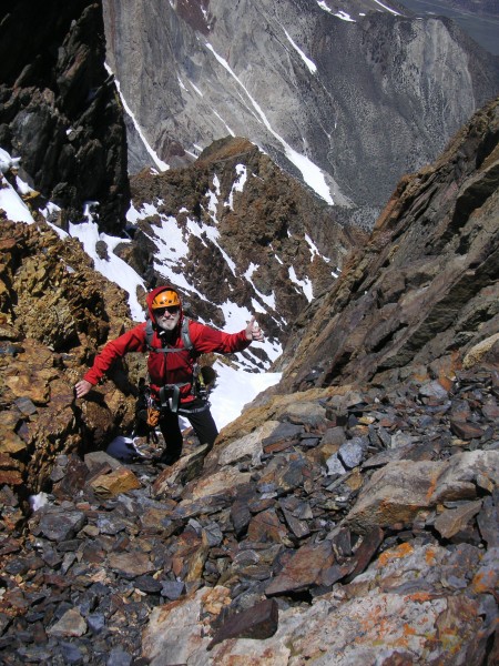
Shattered, broken rock? Sure, saw lots at the end of and some high in the gully, and especially on the several hundred feet of hiking from the intersection of the gully with the shoulder of the peak.
How do YOU think the rock and routes compare to those on Temple Crag? (my experience there, so far, is limited to the Moon Goddess and Venusian Blind aretes)... and other Sierra routes?
Cheers!
Bill
|
|
rdh
climber
|
|
|
|
Jun 15, 2011 - 03:33pm PT
|
A few pics from Morrison's DNB - it goes directly up the prow of the main buttress.
|
|
BMcC
Trad climber
Livermore
|
|
|
Author's Reply
|
Jun 15, 2011 - 03:43pm PT
|
RDH -
Thanks for posting the cool pics of the Direct North Buttress. While methinks there's a bit of loose rock in a couple of them, it looks like some good adventuring!
Bill
|
|
BMcC
Trad climber
Livermore
|
|
|
Author's Reply
|
Jun 16, 2011 - 03:43am PT
|
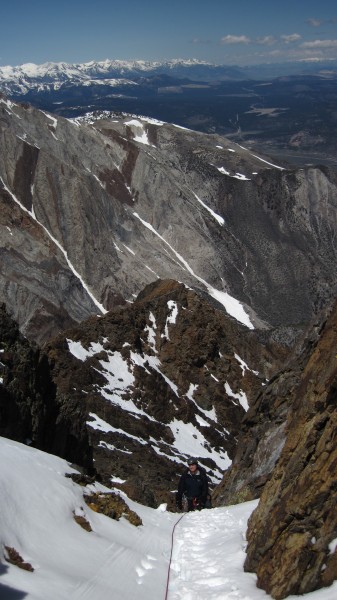
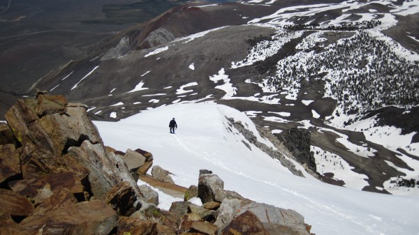
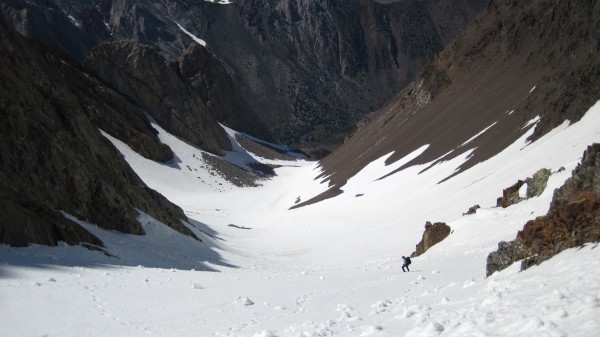
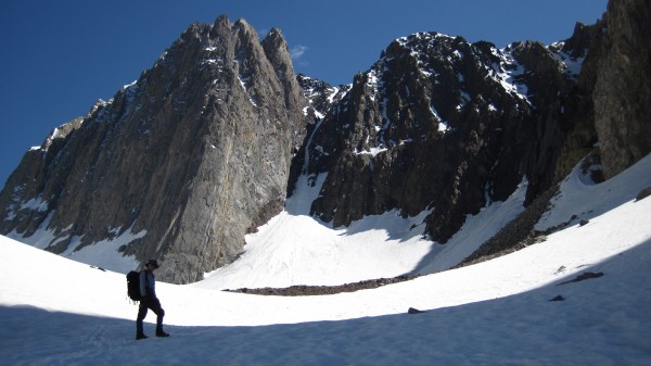
Here are two more pictures to provide some perspective as to the overall length of the couloir on Mt. Morrison... it's much longer than what one can see when looking up from the snowfield below the ice.
|
|
ß Î Ø T Ç H
Boulder climber
ne'erdowell
|
|
|
|
Jun 16, 2011 - 03:55am PT
|
The central spur on mt morrison is 5.10 and called don julie.
Those DNB pics are crazy too. Props to all.
|
|
Ezra Ellis
Trad climber
North wet, and Da souf
|
|
|
|
Jun 19, 2011 - 08:08pm PT
|
Awesome TFPU! It has been A COLD SPRING!!!
|
|
Gagner
climber
Boulder
|
|
|
|
Jun 19, 2011 - 11:18pm PT
|
Hey Bill -
Long time....
Thanks for posting up ... Rick, I mean Mr. Ingonito - sent me the link. Let me know if you ever make it out to CO.
WOO HOO!!!!
Paul
|
|
bergbryce
climber
East Bay, CA
|
|
|
|
Jun 19, 2011 - 11:35pm PT
|
This is awesome.
TFPU.
|
|
BMcC
Trad climber
Livermore
|
|
|
Author's Reply
|
Jun 20, 2011 - 02:41am PT
|
Hey back at you Paul,
Long time? Seems like just a few years ago we talked at the Pinnacles or a few days later that you were sharing your insights on the Black Ice Couloir. Time flies.
Was in Ouray in January. Will contact you before the next time.
BTW: Your Sunkist climb, pics, and TR were outstanding! http://www.supertopo.com/tr/Sunkist-May-2011-Threading-the-Needle/t11026n.html THANKs for posting.
Bill
|
|
BMcC
Trad climber
Livermore
|
|
|
Author's Reply
|
Jun 20, 2011 - 03:29am PT
|
Thanks, all, for your comments!
As I mentioned in the TR, my partner and I felt lucky that we even learned that the route had ice and then so very lucky that the ice hung in there long enough for us to eventually make it over to the East Side to get on it.
TRs and/or posts by Gil, Frank, PeterC, and Stewart on the route and conditions were very helpful in informing us and I have no complaints about our COLD spring.
Cheers!
|
|
PellucidWombat
Mountain climber
Draperderr, by Bangerter, Utah
|
|
|
|
Aug 25, 2011 - 09:20pm PT
|
Sweet! Looks like a great route. Thanks for posting such great pics!
|
|
NotIt
Trad climber
SF, CA
|
|
|
|
Aug 25, 2011 - 10:31pm PT
|
TR bump because you climbed it on my birthday.
Also, strong work.
|
|
ß Î Ø T Ç H
Boulder climber
ne'erdowell
|
|
|
|
Feb 15, 2017 - 10:38pm PT
|
... should be hideously phat this year.
|
|
tradmanclimbs
Ice climber
Pomfert VT
|
|
|
|
Feb 17, 2017 - 03:26am PT
|
Nice!
|
|
Nick Danger
Ice climber
Arvada, CO
|
|
|
|
Feb 17, 2017 - 09:26am PT
|
Missed this the first time it was around. Now That Is What I Am Talking About! I just cannot imagine a day in the high country being any more wonderful than this must have been. Ice-filled couloirs on spectacular-looking mountains - it just makes me weep with happiness.
Boffo performance, dudes.
|
|
Bad Climber
Trad climber
The Lawless Border Regions
|
|
|
|
Feb 17, 2017 - 03:35pm PT
|
Great pic, Jody.
BAd
|
|
Vitaliy M.
Mountain climber
San Francisco
|
|
|
|
Feb 19, 2017 - 04:06am PT
|
Thanks for the bump, hope the couloir comes in! There is a good chance for sure! And ice nine may come in too.
|
|
Gnome Ofthe Diabase
climber
Out Of Bed
|
|
|
|
Feb 19, 2017 - 04:59am PT
|
Awsome TR
And a fun thread.
Some great pictures !
O!! Hey V.
Congrats on the Mugs Stump award!
Got an objective ? trip plans? Can't say? Keeping it quiet till the tr!
I hope we see at least a link.
Yôu won't get this but others might;
"Bg time, Ronnie ~ Big time"
|
|
splitclimber
climber
Sonoma County
|
|
|
|
Feb 28, 2017 - 09:54am PT
|
snowboarded Morrison Col on Friday and got a good look at this climb.
Ice is NOT in right now. Looked to be all rock for 50-70 feet at the base.
|
|
BMcC
Trad climber
Livermore
|
|
|
Author's Reply
|
Mar 2, 2017 - 08:14am PT
|
About 45 minutes after sunset ...
|
|
ß Î Ø T Ç H
Boulder climber
ne'erdowell
|
|
|
|
Nov 15, 2018 - 12:18am PT
|
c/o Frank Kelly
|
|
Brandon-
climber
The Granite State.
|
|
|
|
Nov 15, 2018 - 08:34am PT
|
That mountain is amazing, and it scares the sh#t out of me. Ill probably never touch foot on its flanks.
|
|
NutAgain!
Trad climber
https://nutagain.org
|
|
|
|
Nov 15, 2018 - 09:01am PT
|
I dunno Brandon, those pics of DNB on Morrison look pretty darn sexy and not as sketchy as I expected. That little voice in the back of your head will keep whispering until you surrender to it!
|
|
McHale's Navy
Trad climber
From Panorama City, CA
|
|
|
|
Nov 15, 2018 - 12:31pm PT
|
Great Bump! Some of that rock up there doesn't look too shabby either!
|
|
|
 |
|
Recent Trip Reports
- The Kohala Ditch Trail: 36ish hrs on foot... to and from the headwaters. [5 of 5]
May 31, 2019; 11:57pm
- A Winter Traverse of the California section of the PCT Part 8
May 31, 2019; 11:18pm
- Supertopo,A trip report for posterity
May 31, 2019; 11:00pm
- Balch Fest 2013. Two Days in and Around and On The Flake. The Official Trip Report
May 31, 2019; 10:57pm
- TR: My visit to the Canoe
May 31, 2019; 10:24pm
- Death, Alpine Climbing, The Shield on El Cap
May 31, 2019; 4:07pm
- Andy Nisbet (1953-2019)
May 31, 2019; 2:11pm
- Drama on Baboquivari Peak
May 31, 2019; 1:19pm
- Joffre + The Aemmer Couloir: ski descents come unexpected catharsis [part 2]
May 31, 2019; 7:45am
- Lost To The Sea, by Disaster Master
May 30, 2019; 5:36am
- My Up And Down Life, Disaster Master
May 29, 2019; 11:44pm
- Halibut Hats and Climbers-What Gives?
May 29, 2019; 7:24pm
- G Rubberfat Overhang-First Ascent 1961
May 29, 2019; 12:28pm
- Coonyard Pinnacle 50 Years Later
May 29, 2019; 12:24pm
- Great Pumpkin with Mr Kamps and McClinsky- 1971
May 29, 2019; 12:02pm
- View more trip reports >
|