Matt Miccioli
Trad climber
Nashville, TN
|
 |
Had to bail on Saturday (7/30). We left an old blue mastercam and a few nuts on the dihedral pitch. Will handsomely reward anyone who returns them. Email me at mmicciol@stanford.edu
|
kfo
Sport climber
|
|
My partner and I bailed from the Red Dihedral on Sunday, 7/20 in a bad hail/lightning storm. The forecast was for scattered thunder storms in the afternoon, so a pre-dawn start was taken to ensure we were off before the afternoon. We bailed from pitch 7 in a crazy storm at 10:30 am. We wanted to get off the route fast and had to leave a lot of gear. Gear was left every doubled rope length where needed to bail. Would sure love to get this back.
Left gear (I think) was: yellow/orange metolius offset, green c4, 3 red c4, 1 blue c4, 1 yellow c4, several orange biners, several slings. Please spread the word that if someone comes across a ton of newish gear that is very clearly from a storm bail to point them in my direction!
$$/beer/vibes/karma will be sent (to your door!) for return for our gear. We are happy to be off safe, and would love to get some of this back.
Thanks,
Kipp
rkf3@duke.edu
310 924 4173
|
Paul B
Big Wall climber
Sheffield, UK
|
|
The difficult to protect section protects well using small - medium nuts and a yellow mastercam. In general the earlier pitches take small nuts (not micro) very well, I had two sets and used the two smallest from each often.
The poor stance noted on the topo has an old SMC bolt, an in-situ wire (equalised with a lot of tat) with a good red/blue WC rock above the bolt to back it up.
The walk in is less heinous than made out in various posts (even with packs).
|
jplaut
Trad climber
San Francisco, CA
|
|
Just climbed this car to car last weekend. Despite it being labor day, we were the only party on the route (although there were numerous parties on Positive Vibes and multiple parties on various other routes).
The topo is pretty spot on. We climbed up to right below the 5.8 bulge on the first pitch and managed to link the 1st and 2nd pitches without too much rope drag (that 5.9 awkward stemming section with poor pro is definitely a bit spicy). We then linked the 3rd and 4th pitches (the Red Dihedral was sustained and pumpy, but protects well. The 10.b move was thought-provoking, but not terribly difficult.), linked 5 and 6, climbed 7 (did the 5.9 fingers/stemming corner on the left instead of the 10a fingers. To be honest, I thought the 5.9 fingers section was great, definitely worth doing if you don't feel like doing the splitter), linked 8-10 in 2 pitches, then climbed 11 and 12. So 8 pitches total, all stellar with the exception of the last 2, which were awkward and dirty.
Regarding approach, the picture provided by tadhunt is accurate (thanks tad!), but there are no cairns so just look for the tree and boulder. The trail was very easy to follow, even on our way back in the dark. All in all, a fantastic romp in the sierras. Will have to get back for pos vibes once I get my 5.11 leading skills up to par.
|
cultureshock
Trad climber
Mountain View
|
|
Check out the page for Positive Vibrations for current info on Red Dihedral and PV.
|
marekjaku
Trad climber
CA
|
|
Has anyone done this recently? Is thre any/a lot of snow? Big crowds?
|
cultureshock
Trad climber
Mountain View
|
|
The gulley is guaranteed to be filled with snow.
Much of the approach is covered as well (which i think makes it easier).
Photos from 4th of July 2011:
http://www.supertopo.com/climbing/thread.php?topic_id=896599&tn=20#msg1546059
|
pumpkineater
Trad climber
California
|
|
Anyone done the descent off the Hulk lately? Conditions?
|
Chris McNamara
SuperTopo staff member

|
|
From Greg Barnes:
Bikes are NO LONGER allowed past Twin Lakes - as of March 30th, 2009. (you used to be able to use them for the first part of the approach)
Everything is now Wilderness - it was part of the Hoover additions to the Omnibus Public Land Management Act of 2009.
Check out the the following map - Twin Lakes is to the right of the upper red number 1:
http://www.calwild.org/pdfs/Map.pdf
No bikes. Period.
|
tadhunt
Trad climber
Sunnyvale, CA
|
|
Yo Chris, thanks for adding link to my "the climb" video. Here's the link to the original forum post with two videos and trip report:
http://www.supertopo.com/climbing/thread.html?topic_id=934528
If you're worried about The Approach, the first video is for you. The second is shot on The Climb.
We didn't have any trouble finding the spot to cross the meadow. Basically you just keep hiking until you find a boulder and a big tree, and --- wait for it --- no less than FIVE cairns marking the turnoff:
[Click to View Linked Image]
Follow this trail down and across to the end of the meadow, then cut straight toward the river. If you're in the right place, you'll see a big boulder and some logs:
[Click to View Linked Image]
After the crossing, we didn't really find a good trail up the wooded hillside. We found a spot where others went up and repeated their efforts. On the way back, it worked out much better -- we ended up coming down along a cairned trail for most of the way, until we could see the big boulder in the river, then a little scrambling got us down over the last few ledges. This seemed way easier (though we were headed down, so you never know).
For the rest of the approach -- just follow the cairns. It seemed impossible to get lost, and your objective is visible most of the time.
We bivied in the last stand of trees below the face. It seemed nice and wind-free. the stream was about 100 yards down and across a big flat area. The flat area near the stream was much chillier when we were there (August 15-16, 2009) than our bivy spot. Though in the morning there was frost inside my bivy sack (thus our last-in-line status on the climb!)
Anyway, my partner has a GPS track for the approach. Drop me a private message and I'll get a copy for you.
|
Chris McNamara
SuperTopo staff member
|
|
great video of climbing the red dihedral
http://www.supertopo.com/climbing/thread.html?topic_id=948399
|
Chris McNamara
SuperTopo staff member
|
|
a request from Hoover Wilderness to keep it clean when camping and climbing on the Hulk http://www.supertopo.com/climbing/thread.html?topic_id=932980
|
Chris McNamara
SuperTopo staff member
|
|
here is a great photo trip report http://bit.ly/11U2nZ less than 5 seconds ago
|
TheLittleUnit
Trad climber
Cambridge, MA (formerly) SF Bay Area
|
|
Did Red Dihedral on July 4th. Kudos to those who do it car-to-car; us sea-dwelling folk were worked enough as it was doing it as a multi-night trip.
The ST approach description is dated. One significant difference is that the Wilderness sign which indicates no mountain bikes beyond that point has been moved considerably closer to the start of the approach...as in, ~1 mile earlier. Common sense will tell you not to veer to the left at this sign, but still, finding the creek crossing is a little tricky, especially if you are relying on the ST directions. We crossed at the beginning of the last meadow before the gully and found the log crossings, no problem. After the log crossing, the trail continues upstream for about 5 minutes and then seems to dead end at a a rock outcropping right next to the stream. At this point, there is a loose climber's trail that heads up a steep sandy slope (we did this on the way up - doable, but we do not recommend it), OR you can 3rd class around the rock outcropping just above the stream for about 20 feet to continue on the main trail. This will lead you to the steep switchbacks through pine trees mentioned in ST.
We chose to camp below the cliff band before the base of Incredible Hulk. It offered more protection from the wind (plus we were just knackered from the hike in).
Clear skies. One party behind us. Still a fair bit of snow in the descent gully but you could hike around it or kick steps in since it softens up quite a bit in the afternoon.
|
OldAndSlow
Trad climber
Los Angeles
|
|
Beta from two oldsters (60) who struggled up the RD last Fri. Great route, sustained, clean, and beautiful.
1. Cross the meadow at the big cairn, cross the stream on the log jam, and a little horizontal third class just above the creek gets you to the climbers trail. Don't go up until it looks like a good trail. We did it in 3.5 hrs carrying packs.
2. The place was hopping. Two other parties on the route on a weekday. They zoomed off, though, so no conflicts or crowded belays.
3. The climb seemed hard for the grade---especially the two cracks. Maybe we've been spending too much time at Red Rocks.
4. The descent is easy and not very exposed. You can make the rappel with one 60m for sure, and probably one 50m with a little 3rd class at the bottom.
|
Mr_T
Trad climber
Northern California
|
|
We made it within 100yds of a camp site, my buddy sprained his ankle, we spent the night, and the next morning went home.
THIS IS ONLY CAMPING BETA:
If you are camping (we were), get a permit. We met two guys in the parking lot who got tossed out by the rangers. You only need a permit for overnights.
If you are camping, there's a good spot about 200-300 yds above the rock band with water falls. It's the flatter area next to the creek. You can camp at the talus field and fill up water from the trickle just below. However up higher you're not as well sheltered from the wind. Since you're getting a permit, you'll be able to get a copy of the Little Slide map from the rangers in Bridgeport. The lower camp I'm describing is about 40 mins from the base (I hiked up to the talus). Higher camp is about 20 mins, but you might not sleep as well.
With lighter overnight gear, we left at 5:30PM, got to camp by 9PM with a 1/2 hour delay due looking for water (we didn't know that above the rock band with the falls, that the trail came back to the creek) and icing ankle in creek. Be careful when hiking in the dark.
|
DParker
climber
Orange, California
|
|
We hiked in to climb the RD on Aug 8 (departed Twin Lakes at 4:30AM; arrived at base at 8:00AM) only to discover one party on the second pitch and two parties waiting at the base. There was also a party on PV with another party waiting. We split shortly thereafter. At least two parties had camped overnight which seems like the best option for this popular route especially on a weekend in prime season.
A few notes about the approach: We headed off trail at the wilderness sign and crossed the creek on logs without getting wet. However this puts you too far right (when facing the canyon) of the climbers trail. Crossing here makes it nearly impossible to traverse back left to pick up the trail. Best to take the advice of the previous post and cut across the meadow with the large rock carn well before the wilderness sign then follow the opposite creek bank until you encounter the trail - you do no want to miss the trail. Be aware that the rock carn is in the middle of the meadow and thus might be difficult to spot in the dark.
|
Shimanilami
Trad climber
San Jose, CA
|
|
We hiked in on 9-Aug, climbed the route and descended on 10-Aug. Some beta:
=> About 300 yards before the sign, there is a meadow with a boulder with a cairn on top of it. If you cut from the trail and head directly at it, you'll avoid mud completely and come to an easy crossing place with double-logs. After this, you can follow the climbers trail along the creek and traverse the rock outcropping (use the little edges near the water's edge). Then you're on the main trail and can't get lost. No sandals needed whatsoever.
=> 60m rope. 7 pitches. There are rap-stations with slings right where you should belay if you want to break it up this way.
=> One #3 Camalot is all you need. Don't bother with a second one. This plus a small nut plus a red alien is good for the belay after the crux pitch.
=> The 10a pitch is awesome. Don't skip this one.
=> For the tunnel, have the follower push the pack through so the leader can grab it. It's easier than trying to drag it through on a sling.
Very fun climb. I'll be back for Positive Vibes later this year, hopefully.
|
Fingerlocks
Trad climber
where the climbin's good
|
|
We did this climb car to car. We left the campground a little after 5, were across the stream by 6, and were climbing by a little after 9. The water was low so the crossing might have been easy anywherewe crossed on logs well to the left and then climbed up just left of the rock band that comes down to the creek. There is a fairly clear trail that cuts back to the right through the pines and picks up the main trail.
I did the climb in four hours and seven pitches using a 70 meter rope, but I think you could use the same belays on a longish 60 meter. In any case, if you start the climb at the 5.8 bulge, then you can link 1 and 2, 3 and 4, 5 and 6, with a 60.
I was happy with a double set of cams from yellow Alien up to purple (#3) Friend and a few mid-sized stoppers. If you want to take extras, the best sizes would be #1.5 Friend and #0.5 Camalot. If you are looking to save weight, you dont need anything bigger than the purple Friend. However, if you only use Camalots, take a #3 since the belay at the top of the dihedral pitch can be done with the purple Friend but probably not with a #2 Camalot. If you want to travel lighter still and are doing more pitches, then take singles at the small and large ends.
From the summit back down to the start was 45 minutes. And we probably would have finished the descent in a little over three hours total, but I didnt pick up my traverse through the pines and we ended up with some extra trudging to get back to our unused Tevas.
There were two parties on Positive Vibrations, but we were the only ones on Red Dihedral.
|
Mike Dahlquist
Trad climber
Oakland, CA
|
|
I wouldn't mess around with the GPS coordinates, the marsh probably changes every year anyway. I found the marsh straight forward, even in the dark. Aim for the east side of the canyon when you cross the marsh and you'll be fine. Once you cross the marsh there is a very good, obvious trail.
|
Shimanilami
Trad climber
San Jose, CA
|
|
Does anyone have or know where to get GPS coordinates for the approach and descent? I may have an opportunity to climb it, but I've never been there and wanted to do it car-to-car in a day. I don't want to futz around in the marsh and figured "bread crumb" coordinates would help me out.
|
bonin_in_the_boneyard
Trad climber
Land of the Has Been
|
|
Here is a sequence of pictures I took of the last move tunnel-through:
http://www.supertopo.com/climbing/thread.html?topic_id=410977
The RD was big and hard. I got a little spanked, but at the same time I feel like I'm starting a new chapter in my climbing. Kudos to everyone who gets up and off this thing.
|
Chris McNamara
SuperTopo staff member
|
|
a SuperTopo user sent me this correction:
Comment on your instructions for the approach to the incredible hulk. you say to turn toward the stream once you reach the wilderness sign - this is erroneous and gets you into the marsh and beaver pond from hell. Your photo shows what I think is an area 300-400 yards before the sign.
You should state that once they reach the sign, turn around and walk back 300-400 yards to the previous meadow - they will see a rock outcropping coming right down to the stream. Walk towards that outcropping and cross the beaver dams and water slightly upstream from it - you will likely have to wade the stream, but totally avoid the marsh. Trying to do this in the dark (can't see the photo) is close to impossible, but is possible if you know to hit the sign, turn around and walk back before you cross into the field.
|
Josh Higgins
Trad climber
San Diego
|
|
This was a great route. The 5.10 pitches are top quality, and the views spectacular. There was definitely snow on the approach, descent, and even the route on 7/2/06, but nothing that wasn't managable. The descent is one of the worst I've ever done. Endless choss in a gully. It took my partner and I much longer than 45 minutes, but that might be because we left our hiking shoes at the base. I figured "hey, 45 minutes isn't too long to suffer!" Boy was I wrong...
Beta:
The river crossing can be done over a 3' log west of the wilderness sign, but then you have to cut back to the east side of the valley to find the climbing trail and that takes a lot of crappy bushwacking. Crossing the river where the climbing trail ends results in endless bog sloshing and a waist deep fording of a cold fast river. I don't think that there is a "good" way across the river, but it might be out there...
For the descent, drop down to the left of the summit, and the rappel is on the LEFT side of the ridge. You have to drop more than the ST recommended 40' to see the rappel station. Once you rappel, take the obviously non-snow choked way to rappeller's left.
Split the last two pitches.
There was a pretty freaking sketchy snow patch between pitches 10 and 11 on the 200' ledge traverse. Sub-optimal...
|
casey
climber
oakland
|
|
yeah - we did the same, we crossed first near the wilderness sign and were quite a bit west of the trail. the whole area is really marshy, we ended up crossing the river in a couple of places. bring sandals. the path is really clear once on the other side, so agreed, if you bushwhack at all you're missing the trail.
what an awesome route. we had it to ourselves last tues. my partner broke his finger (!) and summited anyways! the first 5.10 section felt like a move or 2, i got good gear above my head.. and the 2nd 5.10 crack is amazing. don't skip it!
took us 6.5 hours to do the climb, that's with my partner having a broken finger. i'd love to go back, it was a great time.
also - the cost of parking overnight is now $10. and gas in bridgeport is $3.50!!!! ouch.
|
Friend
climber
|
|
We visited the Hulk 8/24-8/27. On the way in we left the main trail at the wilderness sign; on the way out we emerged well before (east of) the sign. In hindsight, I would say that when you reach the easternmost edge of Little Slide Canyon, as soon as you can look straight left and begin to see up the canyon, cut over and plow through the swamp. The trail enters some pine trees on the very eastern edge of the canyon and immediately ascends up and away from the base of the canyon. It is extremely well traveled and well cairned if you find yourself on a "faint" trail or bushwhacking at all, you're following the wrong footsteps. We did this on the way in and it was a pain.
We climbed Positive Vibrations and the Red Dihedral, using beta from the Supertopos and Peter Croft's book. Both were accurate and helpful. I found the Red Dihedral to be reminiscent of a long Tahquitz route (lots of moderate climbing with a couple hard sections) and Positive Vibes similar to the Rostrum or the Don Juan Wall- steep and sustained. It was an outstanding trip all around.
|
ThomasKeefer
Trad climber
San Diego
|
|
Did this route over the weekend.. Or should say got a bit worked
-Car to car with bikes is the way to go.
 The approach is not near as bad as it seems in the beta page. We went to the sign, and basically followed the ST description and ended up in short section of stream crossings. My partner did not get his feet wet. I had sandles on so didnt bother trying to keep them dry. The crux of the approach right now is getting onto the trail in the pine forest. If you follow the ST route from the sign then work left after you cross the creeks and you will hit it. It swithces back pretty widely so it you get out of the aspens and into the pines you will find it. The approach is not near as bad as it seems in the beta page. We went to the sign, and basically followed the ST description and ended up in short section of stream crossings. My partner did not get his feet wet. I had sandles on so didnt bother trying to keep them dry. The crux of the approach right now is getting onto the trail in the pine forest. If you follow the ST route from the sign then work left after you cross the creeks and you will hit it. It swithces back pretty widely so it you get out of the aspens and into the pines you will find it.
We did the first 4 pitches as 2 but I think that this was a mistake. If I did it again I would 4th class to the 5.8 bulge thus linking 1 and 2 then go to the base of the hard stuff in the red dihedral pitch and stop on top of the last detached flat topped horn. (past where the slings are). I lead from the top of our first all the way to the top of the red dihedral and was totally worked by the end of it and had only about 2 ft of rope left!
I thought that the R.D. pitch was significantly harder than and as sustained as Reed's Direct but maybe I was just not working enough stems.
The exit from the R.D. (5.10b) is, as others have pointed out, trivial.
-The rest of the route is good and very straigtforward. P10 on ST is the only one with any route finding. Stay in the crack system 30-40ft right of the huge detached block above the 5.6 flare. Even if you f this one up you will be at the notch.
On the last pitch, Make sure you are not fat. I am 6'1", 180 and had a pretty tough time getting through the 'hole'.
If you have packs, leave them with the second at the base of the last pitch and then haul them to aviod chimneys with a pack.
TR here: http://www.kimberlykdesigns.com/incredible_hulk.htm
|
Mtnfreak
Trad climber
Lost on the West Coast
|
|
The aproach has changed a little bit this year, possibly due to the extremely high water flow in the Robinson Creek. I recommend the following approach: After heading towards the creek from the Wilderness sign, trend WEST/Upstream/right to cross the braided creek ABOVE the beaver damn swamp. Then head DOWNSTREAM (crossing the Little Slide Canyon Creek) for aproximately 300' and keep your eyes open for a white cairn that marks the beginning of the climber's trail.
Three days ago I hiked in on a recon/trail run and followed the directions above on the approach, and followed McNamara's advice for the descent. From following Chris' directions, and my own stubborn refusal to backtrack, I was forced to 3rd class above the creek (deep water soloing!) before finding a suitable log crossing - Robinson Creek below Little Slide Canyon Creek is above the waist right now, so don't fall in!
|
wilcox510
climber
|
|
Great route, but not very hard for the grade. If you've been intimidated by some of the previous comments, here's what I have to say. There is a total of about twenty feet of 5.10 climbing on this route, between the crux pitch and the splitter thin hands pitch. and they both protect very well. On the approach, if you leave the trail early enough you can cross the stream on a logjam and never get wet. kinda hard to find though. Amazing formation, great route, beatiful day. Loved it. (although i would have to disagree with the poster who said it was better than the casual route on the diamond, but then again, thats my local area.)
|
Oregon Boy
Trad climber
|
|
#1 - don't underestimate this approach
#2 - don't underestimate this approach
#3 - don't underestimate this approach
crossing the marsh sucks. We tried it two different ways, one coming and one going. Both times were miserable. I cannot imagine doing this in the dark for the first time.
On the approach, take the early crossing, before the wilderness sign. If you get to the wilderness sign, I suggest backtracking to find the early crossing, (about 200 yards back). If you find yourself ankle deep in muck, just point toward the canyon, put your head down, and CHARGE.
There is a stream coming DOWN the canyon that joins up with the main stream flowing toward the lake. The sandy switch back trail you are looking for after the crossing is to the LEFT of the steam coming down the canyon if you are facing the canyon.
Other Key Beta:
-Flip Flops without an ankle strap suck if you get into the muck
-spray down with bug spray
-if you're afraid of water snakes...ummm..don't go
|
Chris McNamara
SuperTopo staff member
|
|
Here is a link to an awesome trip report with many photos
http://annwm.lbl.gov/~leggett/pictures/tuolumne_08-08-03/main.shtml
|
DEE
Trad climber
Orange County
|
|
Todd Battey (Stahl Bros.) and I climbed this route a couple of years ago and loved it! The climbing on the crux pitch was harder than I expected as it is a splitter with VERY FEW faceholds for the feet and very slick near the crack. The crux section involves stemming / chimney moves in a very flared chimney section with few positive holds to a jug, and bang, its over! Nothing left but pitch after pitch of fun moderate climbing.
We found excellant camping about a 1/2 mile up canyon from the peak at the lake there. We enjoyed great fishing and total solitude at the lake and watched climbers get stormed off Positive Vibration the day after we climbed the Red Dihedral.
|
clustiere
Trad climber
Orange County
|
|
Oh my this is the best 5.10 mountain crack climbing route I have done, the casual route on the diamond almost touches it but no cigar. THird Pillar of Dana would be great training. Get yer hand cracks on.
|
Sir Run-it-out
Trad climber
Orange County
|
|
Follow the supertopo guide, and head toward Robinson Creek when you see the wilderness sign, and not before, or you will end up fording deep water, as we did on the way in. The meadow may be a bit soggy, but you can avoid getting your feet wet by judicious use of fallen trees. This will lead you to a sand bar at the creek where you want to ford it, with (currently) a log across it, so you don't need to get your feet wet AT ALL. In any case, the stream is less than a foot deep there. The well used climbers trail starts right there.
Splitting the last "tunnel through" pitch into several shorter ones is a good idea, or horrendous rope drag will be yours.
|
dave
climber
Orange County
|
|
Thats right. Just one 60m rope for the route and the descent, as Chris said just a short rap and contour back around to the base. As for the approach avoid the dreaded "beaver ponds" and muck, once you see little slide canyon start thinking about heading off trail towards the creek and crossing it early follow the creek bed once on the other side and scramble up a short bench (15-30 ft.), you may find a hint of a climbers trail here as we did, this way you'll be heading into slide canyon and you'll be high up on the left side of the canyon and out of the brush and muck which clogs the bottom of that canyon. If you get to the wilderness boundary sign on the trail before entering little slide canyon, well then you have gone too far to miss the swamp and will wonder around, wasting time on your car to car ascent, trying to negotiate the bog.
|
Chris McNamara
SuperTopo staff member
|
|
Yikes. Some of those descent tales sound epic.
The descent, if you go thr right way, is actually pretty mellow. You do about 100 yards of 3rd and 4th class scrambling down from the summit then one 80' rappel then a little bit of 3rd class to a long scree section. For the specifics, download the free topo of Red Dihedral at the following location:
http://www.supertopo.com/freetopos.html#red
|
esq
Trad climber
san francisco, ca
|
|
The time estimate for the approach/descent is accurate. We did the route car-to-car Labor Day weekend 2001. We left the car at 400AM, arriving at the base of the route by 730AM. Leaving the main trail and heading up into the radical canyon on the left, we had route-finding problems both crossing and recrossing the stream/creek/marsh area, and the thicket on the far bank. Once in the canyon, trend along the creek until you are forced up and left by a waterfall headwall. Otherwise the approach is pretty obvious. Filter water in the meadow below the Hulk if you need it.
As for the descent, we had two conflicting guidebook descriptions. My partner thought we should essentially rappel back down the face to the right of the route, or somehow wind up in the big gully up and right of the route. I read the R&I or Climbing mag beta saying to exit the formation once you make the summit ridgeline, heading towards the shady/icy gully behind the Hulk. This is the way we ultimately went. There was a rudimentary rap station with some passive pro left behind by a previous party. We may have supplemented stations with our own gear. 50m double ropes got us the 4 or so raps into what was described as a "horribly loose gully." It was. Trending back down along the wall to the base, notice how big the formation is.
We left the Hulk about 6PM, and arrived back at the car by 930PM. I preferred car-to-car since I didn't think the camping was that aesthetic. (Compare: Third Lake/Sun Ribbon Arete, Palisades.) A week after our climb, my partner was in Tuolumne and met two climbers who had earlier made an unplanned bivy on the Hulk's summit, and then the next day spent several hours wandering and rapping back down to the right of the route.
You are in a fairly remote place, and another party of two would be hardpressed to offer effective assistance. Be a very solid "hard 5.10" or 5.11 leader, with an equally competent/fast partner, and you'll have no problem. I wore my helmet. The Hulk/Red Dihedral is good training for Sun Ribbon Arete or Epinephrine!
I'd go back to do the Polish Route.
|
clustiere
Big Wall climber
san francisco, ca
|
|
car to car how was that approach & descent.
|
Cadillac Curt Taras
Intermediate climber
san francisco, ca
|
|
John Robinson of Sacramento and I climbed this route from car to car in a day in July 2001. The rock is Yosemite quality in an Alpine setting. It is rare to find rock quality this good in the High Sierras.
Although we did the approaches and the climb in a day, it would have been nice to slow down and take it all in. Attention leaders: this is a 5.10 route at altitude so train for it before heading up. Also helmets are advised at the base, 1st pitch hase some loose blocks. PS. Leave the Hulk Super Ball where you find it.
And Chris,great work on another great bunch of Topo's.
|
|
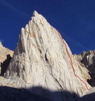
The route as seen from Maltby Lake.Photo: Chris McNamara
|
*What is "Route Beta"?
It's climber slang for information or tips on a route as in, "what's
the beta on that route?" As a service to fellow climbers we ask SuperTopo
guidebook users to post tips and updates to this website if they have relevant
information to share after a climb.
| | | | | | | | | | | | | | | | | | | | | | | | | | | | | | | | | | | | | | | |