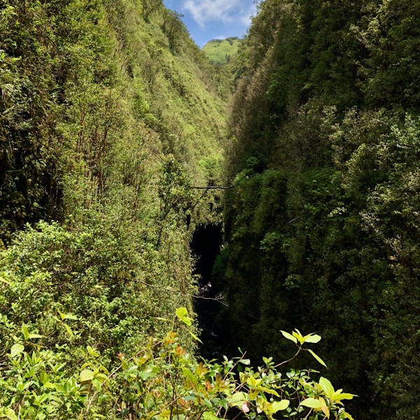
 part two: a japanese garden and a justification for avgas burning Credit: [just above centre is the footbridge over the back of the honopu'e valley] |
||
[Click to View YouTube Video]
if you missed round one, please start here.
if not, and you're interested in a soundtrack, here's one that i was listening to while i wrote this section:
[Click to View YouTube Video]
The Kohala Ditch Trail: 36ish hrs on foot... to and from the headwaters. [2 of 5]
F. The Bank of England: the first central bank and rebuilder of the English navy.
[1694 c.e. or ~ 10 generations ago]
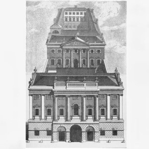 A perspectival drawing of the Bank of England's first non-rented location. Credit: Robert West (1743) |
||
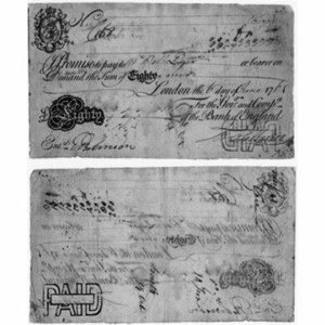 the first partially printed bank notes [that replaced the previously all hand written ones] came into existence at the bank of england in 1725. Credit: bankofengland.co.uk/about/history |
||
"The establishment of the Bank of England, the model on which most modern central banks have been based, was devised by Charles Montagu, 1st Earl of Halifax, in 1694, following a proposal by the banker William Paterson three years earlier, which had not been acted upon. In the Kingdom of England in the 1690s, public funds were in short supply, and the credit of William III's government was so low in London that it was impossible for it to borrow the £1,200,000 (at 8 percent) needed to finance the ongoing Nine Years' War with France. In order to induce subscription to the loan, Montagu proposed that the subscribers were to be incorporated as The Governor and Company of the Bank of England with long-term banking privileges including the issue of notes. The lenders would give the government cash (bullion) and also issue notes against the government bonds, which could be lent again. A Royal Charter was granted on 27 July through the passage of the Tonnage Act 1694. The bank was given exclusive possession of the government's balances, and was the only limited-liability corporation allowed to issue banknotes. The £1.2M was raised in 12 days; half of this was used to rebuild the Navy."
"Although this establishment of the Bank of England marks the origin of central banking, it did not have the functions of a modern central bank, namely, to regulate the value of the national currency, to finance the government, to be the sole authorized distributor of banknotes, and to function as a 'lender of last resort' to banks suffering a liquidity crisis. These modern central banking functions evolved slowly through the 18th and 19th centuries."
en.wikipedia.org
www.bankofengland.co.uk
the republic of the wild pigs: on the bench between honokāne iki and honokeʻā
[09:45ish : 16.06.2018 : km 7.5ish : ~850m gained]
[Click to View YouTube Video]
[Click to View YouTube Video]
after honokāne nui it quickly becomes obvious that a good part of the trail that had stayed open had only remained so due to the wild pigs. frequent areas, that had effectively been tilled by the creatures, along with runnels fit for an animal about quarter human height, made it clear whose hoofsteps i was now following in. but i didn't directly see nor hear them with my own eyes or ears until i got up onto the bench between honokāne iki and honokeʻā...
and so while to this point their keeping the trail open had been a bit of a blessing... here it was a curse.
through this area, hundreds of braided trails made it hard to discern exactly where the often overgrown or damaged portion of the kdt i was looking for was actually at... and that combined with a lot of turned up mud led to this being one of the most demanding parts of the trail. while it's not on film, what was one of the lower points of the adventure had me on my hands and knees crawling through a short pig runnel that was ground into the earth, but also covered at thigh height with interwoven foliage.
i moved quickly as the thought of meeting one of those buggers at eye level, sounded about as appealing as seeing a triangular fin out in the ocean.
fortunately i didn't see anything at exactly that point.
however, probably within 500m i did hear my first evidence of them. i spooked what sounded to be about a half dozen, as all i could see was a movement of the grass and brush as they stampeded away from me.
the only thing i have on video is the aftermath where i once again restarted my bear country derived yelling of "daaaaayyyyy-oh!!" in ernest!
as most of the last couple hours i had been off trail, i felt fortunate to stumble back onto the kdt proper, only a few hundred metres before the waipahi stream and its sizable gulch.
G. James Cook [but maybe an unnamed Japanese sailor or Ruy Lopez de Villabos of Spain]: first non-polynesian to land on Hawai'i
[1778 (or 1542 if R.L.d.V.) c.e. or about seven and a half generations ago]
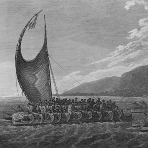
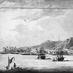 Drawing of Kealakekua Bay during Cook's third and final voyage (1779) Credit: bit.ly/2EHyth2 |
||
 Tereoboo, King of Owyhee, bringing presents to Captain Cook. Credit: Engraving done from a painting by John Webber (~1780) |
||
James Cook:
On January 20, 1778, the British explorer, Captain James Cook, and his ships, HMS Discovery and Resolution, arrived at the mouth of the Waimea River on the Western side of Kauai. Originally, Cook sent three small craft to Waimea so that his men could determine if it was a good place for the ships to dock. They reported back that there was a fresh water lagoon alongside a native village, so Cook and his men anchored their ships and went ashore on smaller craft."
"Cook's mission is thought to be one of scientific and social exploration. His men documented the flora and fauna of the Waimea area, and tried to translate the language of the natives. This first encounter was relatively friendly. One of Cook's men wrote, "On landing I was reciev'd with every token of respect and friendship by a great number of the Natives who were collected upon the occasion; they every one of them prostrated themselves around me which is the first mark of respect at these Isles.""
en.wikipedia.org
Ruy López de Villalobos:
"Ruy López de Villalobos was a Spanish explorer who sailed the Pacific from Mexico to establish a permanent foothold for Spain in the East Indies, which was near the Line of Demarcation between Spain and Portugal according to the Treaty of Zaragoza in 1529. Villalobos gave the Philippines their name, after calling them Las Islas Filipinas in honor of Philip of Austria, the Prince of Asturias at the time, who later became Philip II of Spain. In 1542 he also discovered a Pacific group of islands, most likely Hawaii, but the Spaniard kept the discovery secret."
On the maps of today the Hawaiian Islands lie so blatantly between the east and west-bound tracks of the Galleons, that it seems almost mandatory that some stray must have found them. The inference was first drawn by La Pérouse, who deduced from Spanish charts that islands named "La Mesa", "Los Majos", and "La Disgraciada", in the right latitude but too much far to the east were in fact the Hawaiian group, La Mesa ("the Table") in particular being the main island with the great table-massif of Mauna Loa; the error in longitude was put down to Spanish failure to allow for currents. On one such chart is a note saying that Juan Gaetan, who was with Villalobos in 1542, discovered the group, and named it Islas de Mesa, in 1555; unluckily this chart also gives Cook's name, the Sandwich Islands."
en.wikipedia.org
Hyôryô-min:
"Europeans call drifting ships derelicts once their crews have taken to the longboats. But the Japanese use the word hyôryô for a marine mishap in which a vessel, the hyôryô-sen, loses control and drifts without command. Traditionally its crew and passengershyôryô-min, drifting peoplewould stay aboard, awaiting their fate."
"In half of known hyôryô cases, at least some hyôryô-min survived to reach land. And some of those survivors dramatically affected the societies they beached upon. Around 1260 CE, a junk drifted nearly to North America, until the California Current caught it and sent it into the westbound trade winds, which deposited it near Wailuku, Maui. Six centuries later the oral history of the event had passed down to King David Kalakaua, Hawaiis last reigning monarch. As the tale came down, Wakalana, the reigning chief of Mauis windward side, rescued the five hyôryô-min still alive on the junk, three men and two women. One, the captain, escaped the wreck wearing his sword; hence the incident has come to be known as the tale of the iron knife. The five castaways were treated like royalty; one of the women married Wakalana himself and launched extensive family lines on Maui and Oahu."
"That was just the first accidental Japanese mission to Hawaii. By 1650, according to John Stokes, curator of Honolulus Bishop Museum, four more vessels had washed up, their crews marrying into the Hawaiian aristocracy, leaving their imprint on the cultural development of the islands . Hawaiian native culture, while basically Polynesian, included many features not found elsewhere in Polynesia."
"The Japanese presence in Hawaii may go back much further. Hawaiian legend recounts that the first Polynesian settlers there encountered diminutive menehune (little people), marvelous craftsmen who still dwell in deep forests and secret valleys. At that time, the Japanese were more than a foot shorter than average Polynesians and adept at many strange technologiesfrom firing pottery and spinning silk to forging metalthat might indeed have seemed like marvels."
www.smithsonianmag.com
a japanese garden: the waipahi gulch
[11:15ish : 16.06.2018 : km 8.4ish : ~1000m gained]
[Click to View YouTube Video]
[Click to View YouTube Video]
if the last section was one of the nadirs... then what i found after crossing through the small clearing and past a smallish cabin with a sign saying "awini" on it, was without doubt one of the highlights of the whole adventure.
that's because after kilometers of grown over and sometimes nearly non-existent trail, and steeling myself due to the expectation that that is what i was going to continue to find... suddenly i was presented with what looked to be an immaculately manicured 2m wide road-like path.
to say i was overjoyed, after crawling through pig created muck and swatting away what must have been a hundred cobwebs, doesn't quite capture it.
and to top it all off not only was the path beautiful, but the streams were stunning as well.
i remember thinking during this time that i felt like i had been teleported to japan and i was now in some kind of manicured and curated garden...
when i returned home and began to do more research, i realized that in a way, that's exactly what i had experienced.
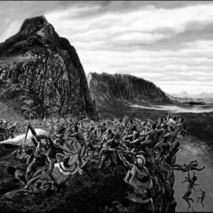
H. The Attempted Kidnapping of Kalaniʻōpuʻu: two depictions of the results of Cook's series of mistakes
[1794 c.e. or about seven generations ago]
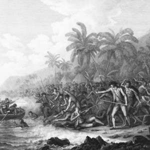 The official version of events: Cook with his arm outstretched telling his men to stop firing... Credit: John Webber [late 1700s] |
||
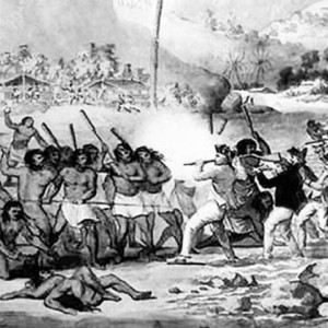 The likely rest of the story: out of bullets and using his gun as a club... Credit: John Clevely [1784] |
||
"The unexpurgated version of the death of Captain Cook, presenting a more realistic version than the familiar heroic scene, has been rediscovered more than 220 years after the deaths of both the explorer and the artist."
"Cook died on a beach in Hawaii on February 14 1779, stabbed in the neck by an islander, in a skirmish which destroyed the previously excellent and profitable relations between the Hawaiians and the British sailors."
"A painting of the scene by John Webber, the official voyage artist, and innumerable engravings of it fixed it in legend: it shows Cook with his back to the mob, nobly signalling to his ships to cease firing on men armed only with spears and a few clubs."
"However John Clevely's version, based on first-hand accounts and sketches by his brother, a ship's carpenter with the voyage, shows Cook fighting desperately for his life, in the last minute of his life, his shot gone, about to club an islander with the butt of his rifle. Most of the islanders have heavy clubs, and others have picked up rocks. One is about to smash the skull of a fallen sailor and the bodies of several islanders are heaped at the water's edge."
theguardian.com
the.honoluluadvertiser.com
both on a known trail and with knowledge as to where on that trail i was! : the honoke'a valley
[12:00ish : 16.06.2018 : km 9.2ish : ~1050m gained]
[Click to View YouTube Video]
[Click to View YouTube Video]
while i had a gps with me, i hadn't bothered to download any maps for it, so all i had was a basically useless very polygonal outline of the shore. i had mostly brought it with me to waypoint every now and again so i could find my way back if i got overly lost.
for maps i had taken some photos of some online usgs maps. these photos were on my phone, so not of the greatest resolution. this meant the combination of the above and what felt like the dozens of streams and gulches i had already gone through, left me uncertain after leaving the waipahi stream whether that had been the honoke'ā valley or just another gulch... so when i actually got to honoke'ā, there was an overly optimistic part of me that thought maybe i was already through to honopu'e...
having not really done much research, i wasn't exactly sure what these valleys were going to specifically look like.
yeah, bare minimum of maps, just enough research to know there might be something out there, and a desire to get out there and see it for myself...
the recipe for a good adventure.
still, it was both a relief and a disappointment when the first sign, that i could recall seeing since leaving pololū was welcoming me to the kohala forest reserve... this brought me back to a collective reality, as that delineation was on the map and told me i was not all of the way through to honopu'e just yet, after all.
I. Kalani Paiʻea Wohi o Kaleikini Kealiʻikui Kamehameha o ʻIolani i Kaiwikapu kauʻi Ka Liholiho Kūnuiākea [aka Kamehameha]: gunpowder and the unification of the Hawaiian islands.
[1810 or about six generations ago]
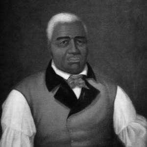 Painting of King Kamehameha the Great by an unknown artist Credit: nah000 |
||
 The conclusion to the Battle of Nuʻuanu Pali by Kāne Credit: 2HrhLFN |
||
"Kamehameha and his Council of Chiefs planned to unite the rest of the Hawaiian Islands. Allies came from British and American traders, who sold guns and ammunition to Kamehameha. Another major factor in Kamehameha's continued success was the support of Kauai Chief Ka`iana and Captain Brown, who used to be with Kaeo okalani. He guaranteed Kamehameha unlimited gunpowder from China and gave him the formula for gunpowder: sulfur, saltpeter-potassium nitrate and charcoal, all abundant in the islands. Two westerners who lived on Hawaiʻi island, Isaac Davis and John Young, became ohana by marriage and hanai of Kamehameha and trained his troops in the firearm use, maintenance and repair."
"In 1795, Kamehameha set sail with an armada of 960 war canoes and 10,000 soldiers. He quickly secured the lightly defended islands of Maui and Molokaʻi at the Battle of Kawela. He moved on to the island of Oʻahu, landing his troops at Waiʻalae and Waikīkī. Kamehameha did not know that one of his commanders, a high-ranking aliʻi named Kaʻiana, had defected to Kalanikūpule. Kaʻiana assisted in cutting notches into the Nuʻuanu Pali mountain ridge; these notches, like those on a castle turret, were to serve as gunports for Kalanikūpule's cannon. In a series of skirmishes, Kamehameha's forces pushed Kalanikūpule's men back until they were cornered on the Pali Lookout. While Kamehameha moved on the Pali, his troops took heavy fire from the cannon. He assigned two divisions of his best warriors to climb to the Pali to attack the cannons from behind; they surprised Kalanikūpule's gunners and took control. With the loss of their guns, Kalanikūpule's troops fell into disarray and were cornered by Kamehameha's still-organized troops. A fierce battle ensued, with Kamehameha's forces forming an enclosing wall. Using traditional Hawaiian spears, as well as muskets and cannon, they killed most of Kalanikūpule's forces. Over 400 men were forced over the Pali's cliff, a drop of 1,000 feet. Kaʻiana was killed during the action; Kalanikūpule was later captured and sacrificed to Kūkāʻilimoku."
en.wikipedia.org
"In 1898 construction workers working on the Pali road discovered 800 skulls which were believed to be the remains of the warriors that fell to their deaths from the cliff above."
en.wikipedia.org
not enough superlatives: the honopu'e valley
[13:00ish : 16.06.2018 : km 10.2ish : ~1150m gained]
[Click to View YouTube Video]
[Click to View YouTube Video]
the path as i entered into the honopu'e valley was entirely enclosed by foliage and carved directly into the side of the cliff like valley sides. as such it wasn't until there was a break in the trees that i could actually get a sense of what was directly opposite of me...
and part of what fuels the helicopter driven tourism that was regularly flying overhead!
what i saw made the challenges i had experienced to that point worth it... and also made me somewhat sympathetic to the avgas being burnt overhead [even if that part was still a bit annoying.]
i wont say too much or use too many superlatives other than to say that if anything these clips make it seem more mundane than it was a 400m or so deep valley with walls that at many point were 80 plus degrees . and with multiple waterfalls cascading down its sides
the hope/plan for these adventures has always been to see if there is a way to link up the seven valleys from pololū to waipi'o valleys on foot [and over the course of a single day if possible] and so my original plan had been to, if i was able to make it!, drop into the honapu'e valley and head out to the coast and see how far i could make it/whether i could make it to the waimanu valley from there starts the well maintained muliwai trail that i had already mostly traversed about five years ago, and that would take me all of the way back to waipi'o
but when i saw honapu'e with my own eyes and realized how deep and steep the valley was and in combination with how sweet the trail to this point had been, i decided to modify the original plans and see if i might be able to keep following the kohala ditch trail to its end
at that point i thought to myself: who knows, maybe if im able to make it to the end of the kdt, maybe its possible that the folks id read about before might have exaggerated the difficulties of getting into waimanu over top of the bench between the end of the kdt and waimanu...
ah yes... hope always springs eternal! :)
it was also as i slowly descended away from the ocean towards the "back" [i was nowhere near to the actual "back"] of honopu'e that i saw the first access to the tunneled portion of the kohala ditch, that i had noticed.
that humans had used hand tools to tunnel through close to 30km [~17miles] of volcanic rock composed mountainside while in a tunnel of that size...
left me with chills running up my spine.
part three is now posted here.