Trip Report
Indian Creek Abandoned Trail: History, Adventure, Fog
Tuesday May 21, 2013 12:41pm
A few weeks ago, some OutdoorGearLab team gathered in Yosemite. Our goal: climb Half Dome in a team of six. The weather was bad so we looked at El Cap. Weather was bad there, too. Time to hike!

I remembered the Old Indian Creek Trail: an abandoned NPS trail and before that a trail used by Indians and herders. Some history of the trail here. I did the first part of this trail when writing Yosemite Valley Free Climbs and doing the approach for Arrowhead Spire and Arrowhead Arete. I remember it as a well-built trail that periodically vanished.

We asked a ranger and a few store employees about the trail and everyone said the same thing: yeah, I've been up there… a little ways… and then turned around. The only beta we had was "when you get to the fourth class, go right."

We started up and within 25 minutes were at the junction of where the Arrowhead Arete/Spire climbers trail cuts left. A few minutes later we were at the base of the fourth class and a trail fork. We went left. Why in spite of being warned not to? Because the trail left just looked so much more traveled than the trail that went right. The fourth class turned out to be real fourth class. There was even a rap sling about 80 feet up around a tree. Not a good sign. As far as I know, the NPS has never built a trail that might require a rappel.

Of course we were were off route. Or rather, on route had we been doing the alternate Arrowhead Spire descent (not mentioned in SuperTopo Yosemite free climbs). A rock buzzed Randy's head and we knew we had to get back right. Five minutes later we were back on the old path.

For the next few hours, we stayed about 80% on route. It's very apparent why few hike this trail: its well-built and obvious in sections and then completely disappears for hundreds of yards. High adventure factor.
top left corner top right corner
Looking back at Arrowhead Spire. This photo is taken when off route. T...
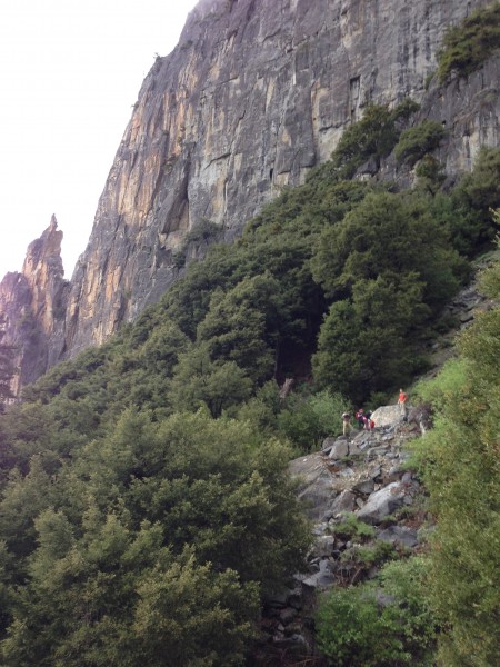
Looking back at Arrowhead Spire. This photo is taken when off route. The group is on route on the Indian Creek Trail.
Credit: Chris McNamara
bottom left corner bottom right corner
The trail does not take an intuitive line and its super easy to get lost. You feel like you should be hiking towards the middle of the canyon, but the trail hugs up and left and goes over many cliff bands. I have read reports that you can just hike the middle of the canyon but this appears to involve lots of boulder hoping and some mandatory 3rd/4th class.

Three hours of rain, fog and (mostly on-route) hiking led to the final traverse back to the middle of the canyon and Indian Creek. This last seciton is quite overgrown and involves "on route bushwhacking." The trail is obvious at this point, but so is the dense brush covering it!
top left corner top right corner
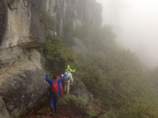
The on route bushwhacking near the top of Indian Creek Trail.
Credit: Chris McNamara
bottom left corner bottom right corner

We topped out and headed back to the Yosemite Falls Trail. If the Tioga Road had been open, we would have hiked up to that and found a shuttle back to the valley (and saved the knees from 3000 feet of granite stair pounding).

top left corner top right corner
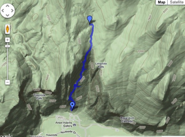
Indian Creek Trail route we took
Credit: Chris McNamara
bottom left corner bottom right corner

top left corner top right corner
Indian Creek Trail
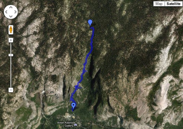
Indian Creek Trail
Credit: Chris McNamara
bottom left corner bottom right corner

The stats by MotionX

top left corner top right corner
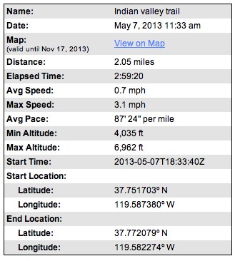
Indian Creek Trail Stats
Credit: Chris McNamara
bottom left corner bottom right corner
I had heard a tourist earlier on the shuttle bus mention the "tight rope walker." I thought, "She is so confused. What she means is someone doing the Tyrolean traverse on Lost Arrow Spire". But in fact she was right: there was a tight rope a.k.a. a slack line right in front of the Falls. The fog, rain and exposure made for an eeriliy awesome scene.

top left corner top right corner
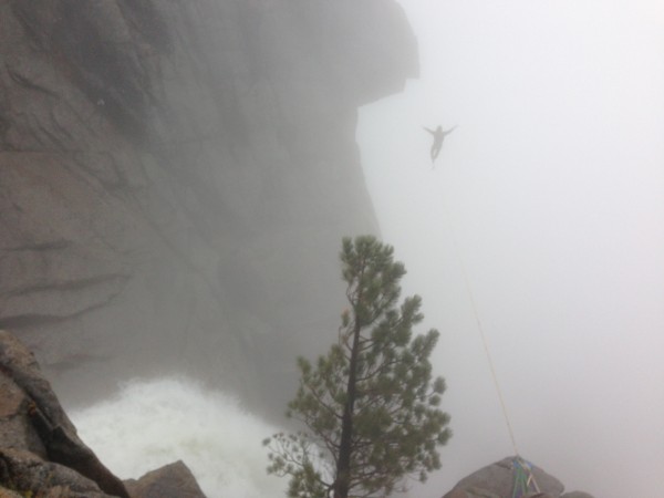
Highline slack line above Yosemite Falls.
Credit: Chris McNamara
bottom left corner bottom right corner


Advice for future groups:
 be a confident 4th class climber, you may be scrambling
 if you don't know what 4th class is, don't try this trail
 if you see rap slings you are off route, maybe
 start VERY early and alllow lots of time to get lost
 wear pants for the overgrown "on-route bushwhaching" up high

  Trip Report Views: 4,643
Chris McNamara
About the Author
Climbing Magazine once computed that three percent of Chris McNamara’s life on Earth had been spent on the face of El Capitan – an accomplishment that left friends and family pondering Chris’s sanity. He has climbed El Capitan more than 70 times and holds nine big wall speed climbing records. In 1998 Chris did the first Girdle Traverse of El Capitan, an epic 75-pitch route that begs the question, “Why?”

Outside Magazine called Chris one of “the world’s finest aid climbers.” He is the winner of the 1999 Bates Award from the American Alpine Club and founder of the American Safe Climbing Association, a nonprofit group that has replaced over 5000 dangerous anchor bolts. He is a graduate of UC Berkeley and serves on the board of the ASCA and the Rowell Legacy Committee. He has a rarely updated adventure journal, maintains BASEjumpingmovies.com, and also runs a Lake Tahoe home rental business.

Comments
RyanD

climber
  May 21, 2013 - 12:52pm PT
Cool!
Ghost

climber
A long way from where I started
  May 21, 2013 - 01:14pm PT
"On-route bushwacking" Gotta love it.
frank wyman

Mountain climber
montana
  May 21, 2013 - 01:22pm PT
Attempted this trail back in 1973 or 1974. If "Old Indians" can do it then why not us in our "Waiter Shoes" After all Were climbers...right? Needless to say we got our A$$ handed to us hopelessely off route, Stumbled back to the dorms all beat up and humbled by the "Old Indians". Guess we should have done more research, but guides and advice were not taken..
guido

Trad climber
Santa Cruz/New Zealand/South Pacific
  May 21, 2013 - 01:57pm PT
Up and down several times over the years, a real puzzle.

I do recall seeing some info on this is an old NPS report from the 20-30s?

Good training for Castle Rock Spire approach.
Mungeclimber

Trad climber
Nothing creative to say
  May 21, 2013 - 02:06pm PT
hahaha, nice Guido. I feel a Supertopo edition coming on... "Road to the Spire; Bushthwack, silliness, and wildlife, a how to get lost on approaches handbook."
Chris McNamara

SuperTopo staff member
Author's Reply  May 22, 2013 - 02:20pm PT

Here is the map we used on our Indian Creek Trail adventure. As you can tell, the main utility was figuring out how far we had to suffer on the descent
Mark Hudon

Trad climber
On the road.
  May 22, 2013 - 02:31pm PT
That slack line vid is sort of erie.
Risk

Mountain climber
Marooned, 855 miles from Tuolumne Meadows
  May 22, 2013 - 02:52pm PT
Great trip! I went up Indian Creek to the top and found curious old cables and ladders along the way that helped ascend the tricky spots. Did this route find and use the old cables and ladders?
SCseagoat

Trad climber
Santa Cruz
  May 22, 2013 - 03:08pm PT
Wow. Very interesting. The Slackline...uh uh uh, I guess what Hudon said.

Susan
Clint Cummins

Trad climber
SF Bay area, CA
  May 22, 2013 - 03:14pm PT
It's called "Indian Canyon" in the climber's guidebook and elsewhere.
"Indian Creek" sounds a lot like a sandstone climbing area.... :-)
yosemitemtb

Social climber
Mariposa
  May 24, 2013 - 07:55pm PT
A couple of friends and I did this hike 25 years ago, in the rain of course. We ran across the top to the Falls trail with lightning cracking all around us! Thanks for the trip report, it brought back some great memories.
Peter Haan

Trad climber
Wyoming
  May 24, 2013 - 09:32pm PT
Thanks Chris, very fun to hear about this trail that I have been "hearing about for half a century". I had heard even that there were indian artifacts and maybe an indian-made ladder, pls advise.


"boulder hoping" = boulder hopping. VV. funny.
Risk

Mountain climber
Marooned, 855 miles from Tuolumne Meadows
  May 25, 2013 - 01:23am PT
My best adventure in the canyon started at the NPS Firehouse where I got assigned to go with R. Mackie to look for a lost north-rim party in May 1987 on my first day back for the summer season. Mackie was much my senior, and I figured that the hike up the canyon would be a casual stroll, but I was very wrong. Instead, I was on a the ultimate YOSAR death march with my boss's, boss's, boss to the top and back down the YF trail without much of any stops whatsoever. He said: "if I stop, I'll never start-up again." I was sore for at least a week. Best of all, we became good friends. Great times. I best recall the ladders and the higher meadows near the top with that damp, special smell of the valley rim forests.
neebee

Social climber
calif/texas
  May 24, 2013 - 10:52pm PT
hey there say chris...i just loved seeing this... really felt like i was there, with those pics... (course, the body did not, but the spirit, sure did)... so--twas easy for me, ;))


thanks again,so very much for sharing this neat hike!!
god bless!
Go