Trip Report
6 Days off trail in the High Sierra: Ionian Basin, Tunemah and Martha Lakes, Goddard Creek Canyon
|
Saturday August 27, 2016 5:56am
|
|
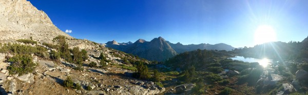
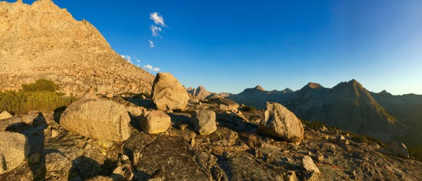
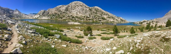
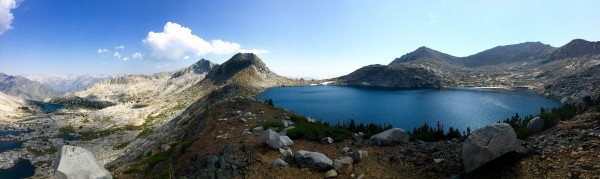
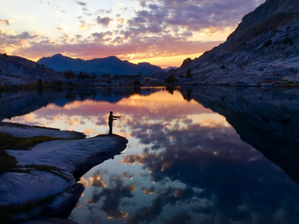
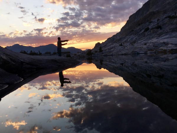
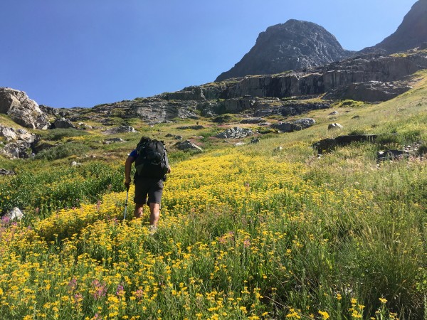
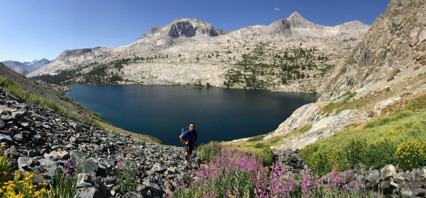
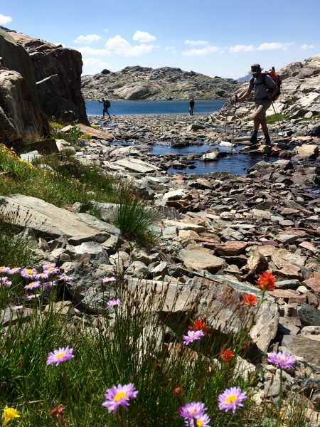
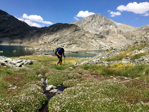
Some photos from backpacking for 6 days west of Bishop. We started at North Lake and walk over Lamarck Col down to the Muir Trail for a couple miles and then west to Martha Lake, Tunema Lake, into Goddard Canyon and up into Ionian Basin. Back to Sapphire Lake and over near the summit of Mount Haeckel to finish at Lake Sabrina.
What is the cool looking wall/spire above Hungry Packer Lake?
Here is the strava track for the last 4 of 6 days https://www.strava.com/activities/684903231
 Chris McNamara
|
|
About the Author
Climbing Magazine once computed that three percent of Chris McNamaras life on Earth had been spent on the face of El Capitan an accomplishment that left friends and family pondering Chriss sanity. He has climbed El Capitan more than 70 times and holds nine big wall speed climbing records. In 1998 Chris did the first Girdle Traverse of El Capitan, an epic 75-pitch route that begs the question, Why?
Outside Magazine called Chris one of the worlds finest aid climbers. He is the winner of the 1999 Bates Award from the American Alpine Club and founder of the American Safe Climbing Association, a nonprofit group that has replaced over 5000 dangerous anchor bolts. He is a graduate of UC Berkeley and serves on the board of the ASCA and the Rowell Legacy Committee. He has a rarely updated adventure journal, maintains BASEjumpingmovies.com, and also runs a Lake Tahoe home rental business. |
Comments
Bad Climber
Trad climber
The Lawless Border Regions
|
|
|
|
Aug 27, 2016 - 06:25am PT
|
Wonderful, Chris. I'm stuck back in the classroom, so this was a nice little shot o' the High Country. I've always wanted to get back into the Ionian Basin.
BAd
|
|
MikeL
Social climber
Southern Arizona
|
|
|
|
Aug 27, 2016 - 06:34am PT
|
Did Ewing catch anything up there?
|
|
10b4me
Social climber
Lida Junction
|
|
|
|
Aug 27, 2016 - 06:34am PT
|
Nice pictures.
|
|
F10
Trad climber
Bishop
|
|
|
|
Aug 27, 2016 - 06:56am PT
|
Picture Peak rises above Hungry Packer Lake
|
|
Sierra Ledge Rat
Mountain climber
Old and Broken Down in Appalachia
|
|
|
|
Aug 27, 2016 - 07:28am PT
|
Nice trip, Chris
Years ago I did a similar trip over 10 days, included some peak climbing and a couple of days just chilling out in beautiful locations. We went:
Lake Sabrina > Wallace Col > Ionian Basin > Enchanted Gorge > Goddard Creek > Ionian Basin > Echo Col > Lake Sabrina.
I've heard the going over Haeckel Col (elev. 12,680+ ft.) is the easiest direct crossing of the Sierra divide in that area, as compared to either Echo Col or Wallace Col. What can you say about it?
Be warned: the east side of Wallace Col (elev. 13,000+ ft.) is a vast unstable scree and rubble slope that would be a nightmare to climb. We descended that slope and it was pretty crazy - we "glissaded" scree. The entire scree slope started slowly rumbling downhill (and I mean the entire slope), so we just "glissaded" down a rumbling scree slope.
Echo Col (elev. 12,400+ ft.) has always been my preferred crossing point, though, even though it is class 3, crossed over it several times.
|
|
skcreidc
Social climber
SD, CA
|
|
|
|
Aug 27, 2016 - 09:20am PT
|
This is sweeet! One of my favorite areas to visit in the Sierra alone or with the right partner.
|
|
L
climber
Just livin' the dream
|
|
|
|
Aug 27, 2016 - 09:26am PT
|
Gorgeous photos!
Thanks for the lovely reminder of what's still out there.
|
|
Ed H
Trad climber
Santa Rosa, CA
|
|
|
|
Aug 27, 2016 - 12:20pm PT
|
The High Sierra - so much to explore!
|
|
mtnyoung
Trad climber
Twain Harte, California
|
|
|
|
Aug 27, 2016 - 12:38pm PT
|
Sounds like a great trip!
|
|
kief
Trad climber
east side
|
|
|
|
Aug 27, 2016 - 12:38pm PT
|
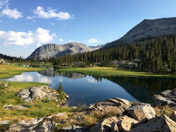
Nice shot of the meadows downstream from the big lake at the head of Goddard Creek (Lake 10,132). The circle within a two or three mile radius of those meadows is probably my favorite part of the Sierra.
|
|
Larry Nelson
Social climber
|
|
|
|
Aug 27, 2016 - 04:26pm PT
|
That Tunemah Lake photo is really cool.
TFPU
|
|
phylp
Trad climber
Upland, CA
|
|
|
|
Aug 27, 2016 - 04:48pm PT
|
Gorgeous!
|
|
yanqui
climber
Balcarce, Argentina
|
|
|
|
Aug 28, 2016 - 06:53am PT
|
Enjoyed the pics
|
|
Gnome Ofthe Diabase
climber
Out Of Bed
|
|
|
|
Aug 28, 2016 - 07:19am PT
|
I've enjoyed this share, I saved it as my wake & bake
this was my way, - Your pictures take me away.
Big C MaC. Thanx
For all the freedom you share
Thanx for posting ,
It is so beautiful
It is almost not fair!
No gush left to cushion the bone on bone that is my ankles .
No gush left to cushion the bone on bone that is my knees
If I could still do anything and do as I please, I'd go and do all of this
All of these!
http://www.supertopo.com/climbing/thread.php?topic_id=2819395&tn=40
|
|
Charlie D.
Trad climber
Western Slope, Tahoe Sierra
|
|
|
|
Aug 28, 2016 - 11:38am PT
|
Beautiful, thanks for posting!!!
|
|
Psilocyborg
climber
|
|
|
|
Aug 28, 2016 - 09:46pm PT
|
such a beautiful area. great shots!
|
|
Ken M
Mountain climber
Los Angeles, Ca
|
|
|
|
Aug 28, 2016 - 11:23pm PT
|
Chris, I want to warmly thank you for this TR. Before my current disability, this area was one of my favorites. What I think of as the true soul of the Sierra, and your TR kindled many memories of wonderful trips.
|
|
EP
Trad climber
Osteoarthritis Shouldervile
|
|
|
|
Aug 29, 2016 - 09:08am PT
|
I sent this to my backpacking partner. He is stoked at the possibilities. Closest we have been is Mono Pass into Pioneer Basin. Headed back to Mineral King next month.
Maybe we can hit this spot in 2017.
|
|
limpingcrab
Gym climber
Minkler, CA
|
|
|
|
Aug 29, 2016 - 12:13pm PT
|
Hmmmm... I though it was only a little over a mile from Tunemah Lake? Haven't been there myself so I could be wrong.
|
|
Charlie D.
Trad climber
Western Slope, Tahoe Sierra
|
|
|
|
Aug 29, 2016 - 02:53pm PT
|
Heading down from Alpine Col to camp on the Darwin Bench, same boulders!!! Thanks again Chris, the Evolution Region is the heart and soul of the range.
|
|
Ken M
Mountain climber
Los Angeles, Ca
|
|
|
|
Aug 29, 2016 - 05:15pm PT
|
Tunemah Peak is only about a mile south-southeast of Tunemah lake
|
|
NutAgain!
Trad climber
https://nutagain.org
|
|
|
|
Aug 29, 2016 - 11:54pm PT
|
Really beautiful spots, thanks for sharing. And cool to see you connecting more deeply with nature without needing the adrenaline spike. That has its place too, but these sorts of trips also form memories that last a lifetime.
|
|
Don Paul
Social climber
Washington DC
|
|
|
|
Aug 30, 2016 - 06:17am PT
|
Looks just like Colorado.
|
|
this just in
climber
Justin Ross from North Fork
|
|
|
|
Aug 30, 2016 - 09:53am PT
|
So it took you 13 days to see the 7 wonders of the world and 6 days to see all this? Ha.
Beautiful pics, I prefer the wonders of the Sierra.
|
|
krahmes
Social climber
Stumptown
|
|
|
|
Aug 30, 2016 - 07:12pm PT
|
Wow thanks CMac for the memories. Seano you are an animal. Did a 7 day in late July 92: L. Sabrina-Lamarck-Evolution-Ionian-Goddard Canyon and out over Agassiz. Sierra Ledge I'm jealous as my orignal goal was Charbydis and the Enchanted Gorge, but my partner said no and we settled for Scylla and Goddard. I don't recommend going all the way down Goddard to the Middle Fork of the King as it was hours of willow.
Here's a couple of poor pictures of the high point of the trip of which was descending into Goddard Canyon during a graupel downpour.And the Lake 10232 at the top of Goddard Canyon which we called Kraken Lake (sorry Randsi) because of the cliffs in the back of lake would release the kraken. What I remember about that lake (besides trying to get dry) is from our camp at the outlet every cast was a fish (they were small), but every cast.
|
|
Roger Breedlove
climber
Cleveland Heights, Ohio
|
|
|
|
Aug 30, 2016 - 03:19pm PT
|
Nice Chris. When I was working in Yosemite, every summer, Marsha and I would hike for a week or two off-trail in the Sierra. So pretty--also the scenery.
|
|
seano
Mountain climber
none
|
|
|
|
Aug 31, 2016 - 09:44am PT
|
Chris -- So true about the glaciers. Even in what's supposed to be a decent snow year, there was no remaining snow-cover on the sad little bits of dirty ice that remain. The Sirens, in particular, are much harder to reach these days than they would have been 10-20 years ago when there was a snow/ice tongue leading to the notch between them and Scylla.
|
|
hamersorethumb
Trad climber
Menlo Park, CA
|
|
|
|
Aug 31, 2016 - 01:33pm PT
|
Wow, great photos. Thanks for sharing
|
|
|
 |
|
Recent Trip Reports
- The Kohala Ditch Trail: 36ish hrs on foot... to and from the headwaters. [5 of 5]
May 31, 2019; 11:57pm
- A Winter Traverse of the California section of the PCT Part 8
May 31, 2019; 11:18pm
- Supertopo,A trip report for posterity
May 31, 2019; 11:00pm
- Balch Fest 2013. Two Days in and Around and On The Flake. The Official Trip Report
May 31, 2019; 10:57pm
- TR: My visit to the Canoe
May 31, 2019; 10:24pm
- Death, Alpine Climbing, The Shield on El Cap
May 31, 2019; 4:07pm
- Andy Nisbet (1953-2019)
May 31, 2019; 2:11pm
- Drama on Baboquivari Peak
May 31, 2019; 1:19pm
- Joffre + The Aemmer Couloir: ski descents come unexpected catharsis [part 2]
May 31, 2019; 7:45am
- Lost To The Sea, by Disaster Master
May 30, 2019; 5:36am
- My Up And Down Life, Disaster Master
May 29, 2019; 11:44pm
- Halibut Hats and Climbers-What Gives?
May 29, 2019; 7:24pm
- G Rubberfat Overhang-First Ascent 1961
May 29, 2019; 12:28pm
- Coonyard Pinnacle 50 Years Later
May 29, 2019; 12:24pm
- Great Pumpkin with Mr Kamps and McClinsky- 1971
May 29, 2019; 12:02pm
- View more trip reports >
|