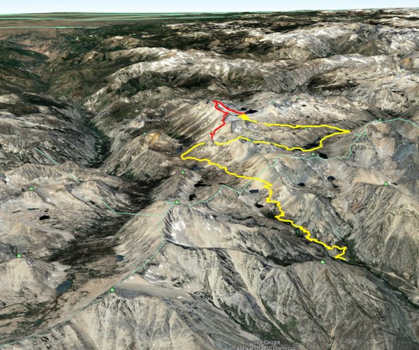
Trip Report
2018-10 Ridge Traverse: Charlotte Col to Mt Gardiner
|
Friday October 26, 2018 2:22pm
|
|
TLDR:
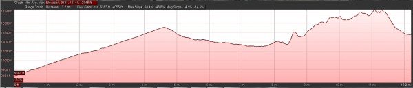
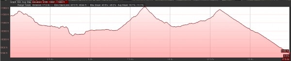
 30 miles, ~2-3 miles of ridgeline class 2/3 with some gratuitous 5th class, and more miles of cross-country
10,600 feet gain and 10,600 feet loss
2 long days but no extreme endurance-fest
[ Click to View YouTube Video]
I can see how solo trips are a habit forming need for more and more: so nice to have complete freedom in route-finding and decision-making; no feelings of guilt for holding up someone faster; no feelings of frustration or extra tiredness going slower than my natural pace to wait for someone else; and lots of time to be present with myself, to become more attuned to my body, to have insights about my breathing and movement that I never had in the last 45 years of my life.
I left Onion Valley toward Kearsarge Pass @ 5:10am. In a classic bit of irony, I was preoccupied with enabling a brand new bit of technology designed to save me (InReach Mini), and then I discovered I was lost in the weeds. I scrambled straight up until I hit the trail, remorseful about erosion, and still not sure if that cost me or avoided bunch of zig-zags. Some time later:
[ Click to View Linked Image]
I found a fancy camera on the trail... and a moment of indecision: leave it for someone down in the parking lot to come back? Or save someone up above a painful back-track? I reasoned that it was lost during a stop, and anybody heading down would be hustling with parking lot fever. So I brought it.
Steven(?) was heading for Mt Gould & Dragon Peak and left a few minutes before me. He was faster, and disappeared until much higher on the trail, where he was very relieved and thankful to have his camera back from me. It's nice to start off the day with some good karma points!
Public service announcement: if you have precious pics on your camera, back them puppies up before going on your trip!
Here's Steven and I enjoying sunrise:
[ Click to View Linked Image]
First rays coming past Independence Peak:
[ Click to View Linked Image]
From 9200ft to 11,760ft and 4-5 miles in a little less than 2.5 hours:
[ Click to View Linked Image]
Steven(?) and I go our separate ways at the pass, from which you can see Mt Brewer dominating the center left distant skyline, with Northgard and Mt Farquhar to the right. That east ridgeline for Northgard looks huge and spectacular. I want to explore that area during my next trip over Kearsarge. In the foreground below those is Mt Bago:
[ Click to View Linked Image]
Looking south off the trail down from the pass:
[ Click to View Linked Image]
Looking south across Bullfrog Lake, toward Farquhar, Northguard, Brewer, Southgard... that would be an epic traverse! And it looks like it can keep going to Thunder Mountain, Table Mountain, Midway Mountain.... how much free time can I stitch together for these adventures? How much time can I dream in google maps 3D satellite view?
[ Click to View Linked Image]
Good morning!
[ Click to View Linked Image]
Glorious lines everywhere you look:
[ Click to View Linked Image]
8:47am, about 3.5 hours to this point:
[ Click to View Linked Image]
I follow the Pacific Crest Trail for a bit toward Glen Pass, and spy Charlotte Dome down canyon:
[ Click to View Linked Image]
She's a beauty:
[ Click to View Linked Image]
I split from the PCT well below Glen Pass and basin on it's southern side; this is where I scramble up dirt and talus, aiming for the saddle below the ridge here. I under-estimated the scale and how hard this part would be:
[ Click to View Linked Image]
I stopped a lot while reaching the local high point near the saddle, but still made pretty good time. I think I got the first word of encouragement from Batrock at this point on the inReach, and it was a very effective and welcome rejuvination. It also made me realize that big brother was watching me, and for the sake of my personal and family reputation for posterity, I had to keep it moving at a respectable pace.
Here's looking down from the local prominence above the saddle... I despaired of scrambling directly to the low point of the saddle, because it required traveling farther up the talus canyon. So I took the "easier" way out of going straight up to gain the plateau. It was steep enough that you can't actually see the path I came up-- just the distant talus below. Not too technical, but the 2-steps-forward-1-step-back deal with some exposure, trying to link larger more stable pieces of stone:
[ Click to View Linked Image]
From that local highpoint, here's the panorama generally facing south. On the upper left is the canyon by which I arrived (Bullfrog Lake is visible), Mt Brewer is the high peak in center, with North Guard to its right), over to Charlotte Dome down low in the middle left, and the ridgeline on the right where I spent most of my day :
[ Click to View Linked Image]
This section was hell... at least half a mile of this stuff, bear crawling hands and feet, sliding sand and small talus, steep enough that I would often lose my balance and tip over backward when I tried to stand up and rest:
[ Click to View Linked Image]
But eventually, I made it to Charlotte Col, a little gap that gives access to the very head of 60 Lakes Basin and views along the spine of Mt Cotter (with Mt Clarence King blocked by Cotter from this perspective).
[ Click to View Linked Image]
My original plan was to drop in there at Charlotte Col. But I had been nursing a plan to do miles of unknown and undocumented ridge traversing all the way over to Mt Gardiner. On the one hand, I rationalized that I would be saving my altitude, but it's no joke to commit to miles of unknown ridge terrain at 11,000-12,000 feet. Those pleasant rounded humps on Google Earth tend to be dramatically sharper and more challenging in real life. What happens if I spend the day getting strung out on that and reach a point with some deep notch that shuts me down? Weather was great, and I had a sleeping bag with me, and I could always backtrack, so I decided to go for it. Looking back at Charlotte Col from near the top of the first gendarme:
[ Click to View Linked Image]
Cool terrain, and the first glimpse of Gardiner Lake in the distance, with a variety of sub-peaks along my journey ahead:
[ Click to View Linked Image]
Looking back in a bit:
[ Click to View Linked Image]
Looking north down 60 Lakes Basin:
[ Click to View Linked Image]
Cool points to tag along the way toward Mt Gardiner:
[ Click to View Linked Image]
Snow on the shadowy north faces, and see if you can find Fin Dome in this pic:
[ Click to View Linked Image]
It towers over Rae Lakes area, and it's lost in grandeur of the surrounding peaks when seen from up high... just a little blob. So much of life is like this- things that seem to loom large and dominate turn out to be not so big if you can just get the right perspective. And sometimes we don't appreciate or can't even see what are the bigger things:
[ Click to View Linked Image]
That rubble tower just screams climb me!
[ Click to View Linked Image]
This is the fuel that will get me up:
[ Click to View Linked Image]
Speaking of energy and ingestion... I know some folks take Diamox to avoid probs even in the Sierra, and when reading about that I found some published research showing that 600mg Ibuprofen at 6 hour intervals had a measurably positive impact (for the first day transition). I tried this and it worked wonders. No issues at all with headaches or malaise.
Getting closer to the rubble tower with some foreshortening. You can see my pack strategy... a little bigger than a BD Bullet type pack, but minimalist from a traditional backpacking perspective. I had a small sleeping bag, ground pad, rain pants and jacket, climbing shoes, mosquito net, water filter, 2 gatorade bottles to refill, and a bunch of powdered Pedialyte. My first time with the Pedialyte and I will keep that as a religion. Food: I made my version of carbonara (pasta, bacon, egg, peas), stuck it in a blender with some butter and olive oil, and froze it into a ziplock bag. Perfect heavy meal for ongoing energy, and the raisins and chocolate gave me the energy bursts.
[ Click to View Linked Image]
Munchin' some chocolate and raisins, feet pointing at Charlotte Dome, summits of Farquhar and North Guard and Brewer clipped off the frame:
[ Click to View Linked Image]
Some really nice stretches of ridge walking:
[ Click to View Linked Image]
Looking back:
[ Click to View Linked Image]
Stick my head over the edge selfie:
[ Click to View Linked Image]
Magnificent panorama in the middle of nowhere selfie:
[ Click to View Linked Image]
The path ahead on the left toward Mt Gardiner, the prominent east ridge I planned to descend dropping down to the right. Mt Cotter forms the right side of Gardiner Basin, and Mt Clarence King is visible beyond. Good spot for a break to take it all in:
[ Click to View Linked Image]
The going gets more interesting:
[ Click to View Linked Image]
I hadn't replenished my bottles at Bullfrog Lake or Charlotte Lake because I took the high road that bypassed their shores.... The water calculation had been a key argument in favor of dropping down to 60 Lakes Basin from Charlotte Col, but for some reason I didn't worry about it when I committed to the ridge. At this point, I was thankful to scoop fistfuls of snow into my mouth and stock up in my bottles:
[ Click to View Linked Image]
Chasing a rainbow... I keep moving along the ridge but Mt Gardiner still seems pretty far:
[ Click to View Linked Image]
Gratuitous shoe shot:
[ Click to View Linked Image]
Another sweet tower:
[ Click to View Linked Image]
Just a glorious spot, pretty far off the beaten path. I can almost see enough of the ridge between Mt Clarence King and Mt Cotter to figure out if I can link up that ridgeline too:
[ Click to View Linked Image]
This tower requires a little chimney-action to get past a spot. There was another place I did a few gratuitous 5.6 moves 20-30 feet above the ridge, with sizeable exposure on one side. I didn't need to, but it made the tower more fun:
[ Click to View Linked Image]
Some warm moist afternoon air moving up valley, starting to get hazy/misty around Charlotte Dome:
[ Click to View Linked Image]
The jumble scramble continues:
[ Click to View Linked Image]
Hazelnut chocolate, nectar of the gods:
[ Click to View Linked Image]
Blue ridges undulating to the horizon:
[ Click to View Linked Image]
Solar radiation makes a big difference in micro-climates. Looking back:
[ Click to View Linked Image]
This ridge is finally starting to look pretty ridgy:
[ Click to View Linked Image]
"Cheese":
[ Click to View Linked Image]
I wussed out and crawled along one knife-edge part where there would be no coming back from a moment of lost balance:
[ Click to View Linked Image]
Back to scrambling, and careful not to drop the phone:
[ Click to View Linked Image]
Somewhere a little farther on?
[ Click to View Linked Image]
Another gratuitous shoe shot... I'm very happy with these La Sportiva TX3 approach shoes- probably my favorite adventure shoe ever. Super light, super supportive, accommodating for the balls of my feet that jut inward and render many shoes uncomfortable for me. And, I tested a bunch of different shoes and these hold an edge way better than any other comparably light shoe:
[ Click to View Linked Image]
The mist coalesces:
[ Click to View Linked Image]
And my path just keeps going and going. Our brains don't really process what it means to go for miles across scrambling terrain. At least mine didn't! I logically knew, but that's not the same as KNOWING.
[ Click to View Linked Image]
For those comtemplating a King-Cotter traverse, note carefully that the North summit of Mt Cotter (on left) is no joke for a solo jaunt. I suspect many a peak bagger for Mt Cotter (higher south summit) has abandoned the north summit for lack of an obvious feasible way to do it. This looks like it would be a GREAT thing to do with a partner and a rope and some gear just in case.
[ Click to View Linked Image]
Ahh, we're reaching that stage of a lazy day where the evening sun casts an amiable splash of copper shimmer across all features:
[ Click to View Linked Image]
My goal is nigh and bathed in molten white light and warmth:
[ Click to View Linked Image]
The rays envelope me, soaking into my bones, where I store it for the long cold night ahead:
[ Click to View Linked Image]
[ Click to View Linked Image]
[ Click to View Linked Image]
Google Earth and topo maps don't make it readily apparent, but the north summit (right) I think is the higher. There is also a center summit on the main ridgeline behind me.
[ Click to View Linked Image]
A wiser man than I would contemplate the sun-bathed slope, the lengthening shadows, and the steeper walls of snow, and formulate a hasty exit strategy. I chose to linger on the tip of the summit and then wander around, taking in the dying day.
[ Click to View Linked Image]
[ Click to View Linked Image]
Ok, time to blow this popsicle stand, get down to that basin for the night:
[ Click to View Linked Image]
The on-site headlamp descent of the ridge proved to be exciting if not overly technical. Several times I came to a dead stop, with my headlamp diffusing into a black abyss in all directions. Cliffed out! But each time it happened, a studious examination of my surroundings would find some steep scramble-down. By this point, I was getting ready for the day to be done. The worst was when I got down the ridge proper, and found myself in a sea of monster talus. It's like from the bottom of the ridge to Gardiner Lake was doing the talus approach to Zodiac or East Buttress of El Cap. The scale of things is befuddling. I accept. I adapt. And I eventually find myself filtering water from the shores of Gardiner Lake. I backtrack a hundred meters to a nice sandy flat spot, the only such spot in an infinite sea of talus. It's as if medusa cast her gaze on the storming seas around Cape Horn and rendered the scene petrified.
Ground insulation matters... that's what makes those unplanned summer bivies on Yosemite granite so chilly. Here, I was wearing a Patagonia R layer, two puffies, 2 pairs of synthetic fleece tights, a balaclava, gloves, and in an old small dirty down sleeping bag, with a breathable "emergency sack" over that. I was laying on top of a half-body thermarest with a slow leak. It was one of the coldest nights in my memory. I lay awake all night, sometimes shivering, sometimes not.... I had been too tired to eat dinner, and I skipped my last does of Ibuprofen. Perhaps these factors made the altitude affect me more. Who knows- at any rate, I did manage to nod off a few times after pre-dawn, and when I awoke I was far more exausted than when I went to bed. The day before I had been excited about figuring out a King-Cotter traverse, and today I just wanted to be a sloth. And at some point I would need to make my up and down and up to Kearsarge Pass and down to Onion Valley.
So I abandoned Mt Clarence King, and even abandoned the easy talus slog up the south peak of Mt Cotter, and committed to just getting out. But, there was one more adventurous tug that I did listen to. As a child, my dad had taken me on a hike to Mist Falls out of Road's End. That whole area was the most beautiful place I had ever seen, and I longed to do the Rae Lake's Loop and see what was up ahead. In the 30 or so years after that, I still haven't managed to do it. So in a nod to that unfulfilled desire, I opted to take the long way to explore more of Rae Lakes area.
First hurdle is getting out of Gardiner Basin. My morning view to the south, showing a small bit of the ridge I traversed the day before:
[ Click to View Linked Image]
The eastern flank is guarded by 60 Lakes Col, which I expected would be a gentle pass. But it's pretty much a broken granite wall. I look up and down and don't see any obvious walk-over point except farther to the south, but I do spy a few weaknesses with a few easy 5th class cruxes. In my exaustion, it's laughable that I don't want to go the extra few hundred meters across talus considering how much I'll be moving this day. But as I get closer and commit, I realize it's actually pretty tame. Hands required here and there, but not more than 3rd class.
[ Click to View Linked Image]
One thing I really appreciated about Gardiner Basin is the rugged, austere solitude and silence. No burbling water. No buzz of insects. The only sounds are the sussurating wind flapping my hood, and at rare intervals a plaintive call of a talus-dwelling bird. In most places, the cacophony of life creates competition to be heard, and a challenge for unique identification. Bird calls are complex, melodic, and probably take a fair amount of energy. In this fortified basin over 11,000 feet, the birds don't need to be fancy to be heard. A brief plaintive cheep is enough to announce their presence to any of their kind, any who might care.
[ Click to View Linked Image]
I can see clearly in my mind the view over 60 Lakes Basin from the top of the col. Glorious streaked stretches of bare granite, like fingernails of a giant beast scratching at the flesh of the land. Layered granite steps connect me from high on the col to that scarred landscape below. And here is interspersed verdant life and running water, a novelty to my senses.
[ Click to View Linked Image]
I did want to see more of Rae Lakes area, but prudence would dictate that I take the most efficient way out, and that would be up to Charlotte Col where I started my ridge traverse. Seen from below, that way looked pretty bleak at the moment. It was pretty darn steep, but more importantly, it was glazed in ice and snow, and I had no crampons or ice axe. So, down 60 Lakes Basin until I reach Rae Lakes Basin.
I dare not risk taking many photos... my phone is at 1% battery, shutdown is imminent. This is more significant because I have never been in this area, I do not have a topo map, and the terrain to reach Rae Lakes is way more complex than I had imagined. In my homework I had not paid attention to the details of getting out this way. Riddled with lakes, large granite outcroppings, and layers of low but significant ridgelines... it is a challenge. I knew clearly where I was in the big picture, but at this moment the details mattered a lot. It could make the difference of a full day of hiking. Worst case scenario I would follow 60 Lakes Basin to it's bottom where it must eventually run into the Rae Lakes Loop, at the far northern end and as far from civilization as you can get on that trail. So I wasn't really lost....
 NutAgain!
|
|
About the Author
NutAgain! is a trad climber from South Pasadena, CA. |
Comments
rmuir
Social climber
From the Time Before the Rocks Cooled.
|
|
|
|
Oct 26, 2018 - 02:28pm PT
|
Great photos of a fine area!
Charlotte Dome is, indeed, fine!
|
|
NutAgain!
Trad climber
https://nutagain.org
|
|
|
Author's Reply
|
Oct 29, 2018 - 10:00pm PT
|
But there was still 1%. At risk of making this political, Thank God for the One Percent! The last thing I did before reaching Onion Valley was pull over on the road and download Google Maps for offline use in the area. It was just enough to show me the bigger topographic features, from which I identified a gap down the ridgeline from Fin Dome, to the north, that didn't seem to be cliffed out. That would hopefully be my way back to Rae Lakes Basin. Over the next couple of hours, I glanced at this topo maybe 4 or 5 times, each time fearing the battery would be dead and I'd be left to reckon with my wits. With more navigating challenges that I would have imagined possible in the Sierra, I eventually reached the rise to the gap that I hoped would bring me salvation. I actually prayed for the first time in a while, "dear lord please let this connect through...."
During that time, I kept waffling on whether I would make a side trip to climb the nearby Fin Dome. On the one hand, it would be a bit of redemption for not getting Mt Clarence King. On the other hand, the uncertainty of my exit and sparsity of information coupled with a specific desire to be out this weekend was weighing on me. I rationalized that Fin Dome was just that little indistinct lump when viewed from the ridge I had been on, which made it easier to pretend that I wasn't missing anything. But deep down I know I was missing something, and I'll be back for a visit at some point. East side of Fin Dome (from a western vantage in 60 Lakes Basin):
As for my exit strategy through the gap... fortunately, it all worked out, and within an hour (and the sighting of a family of deer in a forest and some more route-finding challenges to get over to the correct valley) I was reconnected with the Pacific Crest Trail between Dollar and Arrowhead Lakes. I filled my water bottles, and the next walking stretch was the low point of my trip (emotionally, physically, and elevation-wise). Hot, exausted, malaised, face fully exposed to the punishing rays of the sun... on this trip I had forgotten both my sunscreen and my shade hat. I took out my pony tail and let my hair fall over my face to offer some protection, but the pesky wind would keep blowing it away. Around this time, Batrock checked in to see if I planned to make it out that day. Having a big day seemed like a good way to salvage my honor after surrendering Mt Clarence King, but at this point it didn't seem likely.
Now that I didn't depend on the map, I risked taking a few more pics, each time thinking it would be my last. Fin Dome West Face, from an eastern vantage below in Rae Lakes Basin:
Spying the northwest side... looks like I'm circumnavigating this thing! And to my chagrin, I see that the slopes north of Fin Dome would have permitted my passage, so I wasted a bit of time going farther down-valley in 60 Lakes Basin than I needed to....
And moving along the trail now, finding my pace in the beautiful terrain, looking up at Painted Lady, Dragon Peak, and Mount Rixford:
From a bit closer:
There are many formations in this area I would have wanted to take more pictures of, including a stunning north couloir somewhere around Dragon Peak or Mary Austin or Black Mountain... out of my league for skiing but I'm sure it has been the site of some epic descents that nobody can appreciate unless they have the skills and the persistence to get there, and get out alive.
OK, when I hit the junction with the 60 Lakes Trail I feel like a bonehead.... if I had at least taken the time before my trip to see that trail on the south side of Fin Dome, it would have shaved off several hours of my day, and some complex terrain before the extra PCT distance. But now I know for next time :) That's the edge of Fin Dome in the background:
Now as I make my way up toward Glen Pass, I find that my overall condition is improving. Some cloud cover provides merciful cooling, and I'm finding my pace with my breathing and movement on the easy trail that requires so much less energy than cross-country travel.
I look up to a rocky saddle, surprised that that what seemed like a big pass is so close. I guess I'm getting into the groove of this. But I caution myself against getting excited, telling myself that this is probably not the top. But as I crest it and see a basin opening before me on the other side, my heart rises! There's a bit of traversing on this hump before dropping down, but wait! No! It's going up! Arrrghhh! OK, the real pass must be hidden somewhere around the corner here. What if it's all the way on top of that crest!? Oh, that would be stupid to take a pass all the way to a high point on the ridge. It'll come into view in a moment:
Probably around the corner over there somewhere...
The compacted trail is beautifully made through the steep talus, but that also means you can't really see the trail well from below. It climbs and zig-zags interminably, and I find myself gasping/muttering "what a beast". By the time I make it to the top, it might have turned into "fvcking beast." I did have some bright moments, including my first ever sighting of a Pika hopping around on the rocks and snow. And with all the ice and snow on this relatively flat and groomed trail, I was glad not to be attempting Charlotte Col without an axe and crampons. But I have to say, Glen Pass is glorious. It is all the way at the top of the ridge, traversing on the edge before dropping down the other side. It was swirling in moody mist, teasing that snowfall would be imminent, and I didn't even stop to take any photos here with the battery situation.
The drop down the other side is a steep trail, tons of zigzags, and from this point I was on fire. I knew the first major obstacle was done, and my last would be Kearsarge Pass. I decided I was getting back to the car tonight, and I basically hauled ass non-stop from Glen Pass.
In the solitude of the trail with approaching evening, I discovered patterns in the angle of the slope and how that corresponded to my breathing and pace. I was measuring my inhales and exhales in units of how many steps. As I listened closely to what my lungs wanted to do, I adjusted my pace so that I had an integer multiple of strides per inhale, and the same thing for strides per exhale. Going steeply downhill, I was comfortable with 3 steps inhale, 4 steps exhale. On flatland, it was 2 steps inhale 2 steps exhale. I thought of it like a bicycle gear: the front sprocket is my breathing (how may inhales or exhales per step), and the rear sprocet is the speed of my stride. With this model in my head, I was able to modulate perfectly so that my breathing was always manageable, I never felt a lactic acid burn in my legs begging for a break, and I could just keep moving non-stop! I became a fine-tuned machine, and the miles slipped away.
As night enveloped me and the climb up Kearsarge Pass proceeded, I found myself taking 2 cycles of inhale/exhale for each step, but the strategy was still working! When I would have to step up something that broke the rhythm of the trail, or occasionally when I had lapsed and not breathed enough, I would stop for 10 or 20 breath cycles and then be back on track. Breathing during exertion requires a beautiful balance- too much and you get dizzy with hyperventilation, but if you prioritize what your lungs want, and then modulate your legs to that, it all works out without too much thought.
I debated getting out my rain jacket as I caught some drizzle high on Kearsarge Pass with my little orb of illumination defining my immediate world. I decided it wasn't enough to bother, and before I knew it I was face-to-face with the sign at the top of the pass! I couldn't believe it!
I kept going down the other side, and the realization of how well my body had responded on this day hit me in a profound way. I don't know what a runner's high is like, but this might be the closest I have come to it. I had this strong mix of satisfaction, accomplishment, and also a sort of sadness at something I had missed or lost. I formulated the words in my head, "I am 45 years old and today I finally learned how to breathe." And then a wave of emotion came over me and I started bawling. I was just trucking down the trail, crying out loud, tears streaming down my face. I was silent a while, enjoying the vacuous moment, and then some more bawling and tears. I've had other experiences of release in the context of learning to deal with difficult emotional stuff, but this was the first time that something similar was triggered by physical activity.
In my mind, I was already back at the car, but this damn trail just keeps going and going! That "last little bit" is still about 4 or 5 miles. At one point, I feared that I had overshot the Onion Valley parking lot and I was heading down the mountain toward Independence. I came pretty close to sending a message to Batrock for him to check my position. Then I remembered I could check my altitude on the InReach device: 9400 feet. I didn't remember exactly how high was Onion Valley but I thought it was a little lower. With no further ado, I'm back at the car, jazzed up, and decide not to sleep at the trailhead. I just drive on down to Independence, feeling good and awake, and back home to Los Angeles area where I take a lengthy shower and am out by 3am.
Thank you Batrock for being my cheer leader, supertopo stalker/heckler, and a link to safety that made me feel more comfortable heading out into the unknown.
|
|
NutAgain!
Trad climber
https://nutagain.org
|
|
|
Author's Reply
|
Oct 26, 2018 - 04:01pm PT
|
Moose, how is width now? Widest pano pics are 1440 wide, after I fixed a few oversights. Let me know if I need to make it smaller still.
|
|
bobinc
Trad climber
Portland, Or
|
|
|
|
Oct 26, 2018 - 03:39pm PT
|
Excellent trip! Thanks for sharing.
|
|
limpingcrab
Gym climber
Minkler, CA
|
|
|
|
Oct 27, 2018 - 05:56pm PT
|
I normally hate embedded photos but yours were so clear and fun to look at that it was worth the load time and wide screen :)
Glad your trip worked out and no bears ate your snacks!
|
|
Jan
Mountain climber
Colorado & Nepal
|
|
|
|
Oct 27, 2018 - 08:19pm PT
|
What an epic ! Thanks so much for sharing it.
|
|
Vitaliy M.
Mountain climber
San Francisco
|
|
|
|
Oct 28, 2018 - 10:28am PT
|
Purdy photos, thanks for sharing!
|
|
thebravecowboy
climber
The Good Places
|
|
|
|
Oct 28, 2018 - 11:37am PT
|
nice job! ...but, seriously, milk chocolate?
|
|
yanqui
climber
Balcarce, Argentina
|
|
|
|
Oct 28, 2018 - 01:57pm PT
|
Great photos! I was gonna tell you the other day, but then I forgot.
|
|
JLP
Social climber
The internet
|
|
|
|
Oct 29, 2018 - 05:32am PT
|
Nice! A GPS track would add some context? I miss the Sierra, its been a few years, just amazing out there.
|
|
EdwardT
Trad climber
Retired
|
|
|
|
Oct 29, 2018 - 06:14am PT
|
Beautiful photos. Looks like an awesome adventure.
TFPU
|
|
Gary
Social climber
Desolation Basin, Calif.
|
|
|
|
Oct 29, 2018 - 07:03am PT
|
Really nice report. Tough couple of days, eh?
|
|
Tarbuster
climber
right here, right now
|
|
|
|
Oct 29, 2018 - 07:26am PT
|
I can see how solo trips are a habit forming need for more and more: so nice to have complete freedom in route-finding and decision-making
no feelings of frustration or extra tiredness going slower than my natural pace to wait for someone else; and lots of time to be present with myself, to become more attuned to my body, to have insights about my breathing and movement
Exactly!
I once knew a guy who used to do a fair amount of this, and he reported much the same.
Thanks for all the big fat vistas!
|
|
jbaker
Trad climber
Missoula, MT
|
|
|
|
Oct 29, 2018 - 07:44am PT
|
Sounds like a great trip! I haven't done a solo trip for a while and miss the solitude and enhanced attention to everything that is going on around you.
|
|
phylp
Trad climber
Upland, CA
|
|
|
|
Oct 29, 2018 - 07:55am PT
|
That was a real pleasure to read. Thanks!
|
|
Urizen
Ice climber
Berkeley, CA
|
|
|
|
Oct 29, 2018 - 08:49am PT
|
You aren't the first to be humiliated by Mt. Clarence King. Or, to state it another way, you aren't the first to be sandbagged by Secor. His easy route doesn't seem to exist, and I'm not the only one to have learned this the scary way. If you look around you'll find tales of inadequate racks and unplanned bivouacs.
Next time, try enhancing your masochistic pleasure by going over Baxter Pass instead.
|
|
NutAgain!
Trad climber
https://nutagain.org
|
|
|
Author's Reply
|
Oct 29, 2018 - 10:00am PT
|
Bump for info added re: the route detail and mileage/elevation.
I think if I had better ground insulation, I would have gone for King and then I might have gotten sketched out because I didn't have any beta details other than my memory of reading prior to the trip.
|
|
hailman
Trad climber
Ventura, CA
|
|
|
|
Oct 29, 2018 - 10:27am PT
|
Thanks for postin up! That is some solid solo tripping!
As to your observation
I suspect many a peak bagger for Mt Cotter (higher south summit) has abandoned the north summit for lack of an obvious feasible way to do it. This looks like it would be a GREAT thing to do with a partner and a rope and some gear just in case
I'd agree, it would be pretty scary to traverse Cotter to Clarence King. Caught a portion of the north summit in this pic:
And yes, the last 50 feet or so of Clarence King is sandbagged. You take a 5.10 thin hands crack on the right or a chimney on the left. I opted to aid the crack with a few handy cams (oh jeez is that too much beta?!)
Here's the cruxy section I'm talking about:
Props if you can style the summit block. For each of us it was a grunt and scootch affair!
|
|
Urizen
Ice climber
Berkeley, CA
|
|
|
|
Oct 29, 2018 - 10:49am PT
|
hailman, that 2nd photo looks exactly like where I started climbing back down!
|
|
Larry Nelson
Social climber
|
|
|
|
Oct 29, 2018 - 01:24pm PT
|
One of my favorite areas of the Sierras.
Great pictures, well written, and interesting ridge traverse. Thanks for the TR.
|
|
hailman
Trad climber
Ventura, CA
|
|
|
|
Oct 29, 2018 - 01:44pm PT
|
nice Urizen, I don't blame you for backing off. It's a short section but no way would I "third class it" without a belay, ha!
We were crawling all over the peak like ants trying to find the easy way and got funneled into that area. I think this mystical route lives on in RJ's dreams (RIP)
|
|
hailman
Trad climber
Ventura, CA
|
|
|
|
Oct 29, 2018 - 03:52pm PT
|
Ah man nice, so Mr. Burd went the same way as Urizen and me too! Although it sounds like he styled the "two inch crack in an open book that was about 15 feet high" much better than I did.
Only thing I'd take issue with, is that it's a bit smaller than two inches. I aided off a purple (0.5) and green (0.75) camalot.
OK, now that is too much beta!!!
Thanks again for all the great pics. It is addicting hanging out on the Sierra summits at sunset ... nevermind getting down in the dark ... always some way to figure it out!
|
|
seano
Mountain climber
none
|
|
|
|
Oct 29, 2018 - 05:18pm PT
|
Fun route! You could have saved some time on the way out by going over North Dragon Pass -- Glen to Kearsarge was only necessary back when the bighorn closures were in effect.
Farquhar, Northguard, Brewer, Southgard... that would be an epic traverse! And it looks like it can keep going to Thunder Mountain, Table Mountain, Midway Mountain.... It's fourth class from Farquhar to just before Thunder, but Thunder's north ridge looks kind of serious, and there is major gnarliness between Table and Thunder.
|
|
NutAgain!
Trad climber
https://nutagain.org
|
|
|
Author's Reply
|
Oct 29, 2018 - 05:50pm PT
|
Thanks for the heads up on North Dragon Pass... this looks like it would be a perfect complement for my next visit in the Rae Lakes / King area:
http://climber.org/reports/2006/1508.html
|
|
Risk
Mountain climber
Marooned, 855 miles from Tuolumne Meadows
|
|
|
|
Oct 29, 2018 - 08:43pm PT
|
I guess you reevaluated your "urban mindset" after all! Kidding aside, this excursion tops possibly all here. Totally classic. Such solo ridge line trips with just you to decide to continue or descend are the very best, as you revealed to us. Really enjoyed reading and viewing, twice already.
|
|
NutAgain!
Trad climber
https://nutagain.org
|
|
|
Author's Reply
|
Oct 29, 2018 - 10:34pm PT
|
A few more replies:
1. Sorry cowboy, but milk chocolate is way better than dark. There. I said it.
2. Delcross, yes, this was definitely more in the planned bivy category than a "car to car possibly with a nap" category. As soon as I committed to that, I thought it would enable tagging the two highest spots inside the Rae Lakes Loop... but I slept poorly and abandoned even trying Clarence King (and Cotter looked less interesting from Gardiner Basin side- just tiring).
3. I didn't touch the slopes of King at all, just saw it from afar, and posted some references to other reports of people doing it as motivation for the next time I head that way.
4. Risk, I'm more comfortable being in the boonies than I am being in places with tons of people. My career for a few decades kept me in cities, but now I can do it from anywhere with good Internet. But I'm tethered to city life still for weekends with my kids and my wife's career.
Beta question to Urizen - would it be worth bringing a shorter rope (e.g. 20m or 30m) for King? Or should I just keep the whole 60m intact? Maybe that would give more options for a traverse across both summits of Cotter and other technical excursions?
|
|
micronut
Trad climber
Fresno/Clovis, ca
|
|
|
|
Oct 30, 2018 - 07:03am PT
|
Dude, I have ZERO time at work today to read this thing. It looks amazing. Can't wait to find some time to snuggle up with this TR and drink it in. Comments to follow.
Scott
|
|
Risk
Mountain climber
Marooned, 855 miles from Tuolumne Meadows
|
|
|
|
Oct 30, 2018 - 08:30am PT
|
NutAgain! I can fully relate to being sequestered away from the boonies as well. Wife and kids yanked me away from the Sierra before the turn of the century. Two decades later, I've put on weight and have sunk so far into my desk chair, I'll likely never see those ridges in person again, except from airlines or with binoculars.
|
|
Inner City
Trad climber
Portland, OR
|
|
|
|
Oct 30, 2018 - 09:19am PT
|
Thanks Nut,
That was a cool trip report. That area is one of the many Sierra awesome locations.
We did a Fin Dome, Clarence King trip and had a fantastic time despite some on and off rain.
That top of Clarence King is definitely airy and memorable. I think the cord would be very helpful for most folks. My own walrus roll on to the summit block does not bring me back proud memories, but we had a fantastic time up there.
I am impressed with your solo travel, reflection is certainly enhanced when alone.
|
|
NutAgain!
Trad climber
https://nutagain.org
|
|
|
Author's Reply
|
Oct 30, 2018 - 07:32pm PT
|
Two decades later, I've put on weight and have sunk so far into my desk chair, I'll likely never see those ridges in person again
It's amazing what difference even a small change in habit can make. Before summer, I was in pretty much the same boat. I had accepted getting fatter and having an aging declining body. I did zero exercise in an average week, working from home and not evening going to the climbing gym any more. Maybe a trip out to Tunnel Crags every few months with Batrock. I'm only 45! But a trip up Mt Emerson with my wife in early July, that was pushing our limits, and encouraged us to get in shape. Wifey found a class that we both go to every morning- a 1 hour core body workout at Pop Physique. It is a perfect complement to rock climbing, killing the muscles that you don't use as obviously during a climbing gym session but that you need for big adventures. I'm the only dude in a class full of women, many in very good shape. The class kicks my ass every day, but we both have noticed major changes in our abs, butt, shoulder, and leg strength. And my pot belly went down a lot. Plus, the daily shared activity has been good for the marriage, and the mutual encouragement has been highly effective.
I've gotten in shape enough where I look forward to exerting myself now, rather than dreading it. And I still can drop probably 20-30 pounds of fat before I'm in hardcore shape.
So don't surrender- just create a small routine and figure out a support network to help you stick with it, and don't worry about the long term goal. Just make it a goal to do it every day or a few times a week.
|
|
le_bruce
climber
Oakland, CA
|
|
|
|
Oct 31, 2018 - 01:34pm PT
|
Beautiful beautiful beautiful
Fan-f*#king-tastic Scott! So glad you got out there. What a quiet and beautiful season for it. Thanks for sharing it with us.
|
|
Urizen
Ice climber
Berkeley, CA
|
|
|
|
Oct 31, 2018 - 04:10pm PT
|
I wanted to have a chance to consult my notes from 2014, but all I learned was that I didn't really have any. Went west over 60 Lakes Col, from which it was easy to tag the summit of Cotter. I didn't like the look of Secor's recommended route around the north shore of Lake 11407--too much side slope and scree. So I went around to the south and camped near the outlet. Next day was for Gardiner via the NE chute. I moved camp that evening just for the novelty. Next day I started over King Col, which wasn't so easy to find. Then I decided that the evident route that would descend to the east of the lakes would bring me too far down towards Woods Creek, so i deviated right and went down something steeper, narrower, and looser. Call it King Couloir. There was a dearth of tent sites in the drainage to the west of the King Spur, but I settled in somewhere and started up Secor's alleged "Grade 1" N Ridge route on the next day. You gradually traverse to the SW and gradually get more extremely exposed and gradually get onto something beyond 4th class terrain. The rest, you already know. I suppose that if I had realized I was so close to the summit I would have been more inclined to attempt the crux moves. On the other hand, not knowing that possibly meant that my bones are not now resting on the glacier. So I can't give you any beta about ropes, because I didn't have one.
|
|
Ezra Ellis
Trad climber
North wet, and Da souf
|
|
Thanks for all your wonderful contributions to this site, nut job 👍👍🎊🍻
|
|
micronut
Trad climber
Fresno/Clovis, ca
|
|
Finally found a bit of "me" time to sit down and enjoy this read. What a fantastic voyage, for the body and for the mind. Proud of you for fighting inertia and getting your body back in shape so that it can carry you on an adventure like this. Thank you for taking us along with you. Beautifully written. I covered much of that exact terrain 25 years ago in jeans and a cotton hoodie with two hooligan high school friends. I look back on our photos with awe that we didn't die or freeze but it was the epitome of adventure for us young teens at a time in our lives where we were invincible. Thanks for taking me back in time.
Scott
|
|
NutAgain!
Trad climber
https://nutagain.org
|
|
|
Author's Reply
|
Nov 8, 2018 - 09:11am PT
|
Thanks all for the supportive comments, and del_cross, glad you found the shoes work for you!
Manufacturers each make different assumptions about foot shape (or decide to reduce costs by cutting more patterns out of a given surface area), and that is the most important factor for me. I already know that I like La Sportiva foot shapes more than other climbing shoe vendors, so I was hopeful. It's a big bonus that they are so light, relatively sturdy (considering they are mesh tops), surprisingly supportive, and can hold an edge.
Way more comfortable for me than Five Tennies if I am walking a lot, because those are too boxy with no instep support.
|
|
NutAgain!
Trad climber
https://nutagain.org
|
|
|
Author's Reply
|
Nov 8, 2018 - 01:11pm PT
|
Ha :)
Contrived is certainly a fair adjective for this route when viewed as a climb. The path of least resistance would not be right on the edge, but then it would become a hot dry slog, and I preferred to manufacture some exposure along most of the route just to keep more inspired with the views. There is no point at which exposure is mandatory; south slope bail-out is always an option. I didn't know that going into it, but now we both do and so does everyone else!
Much better to think of it as a scenic hike/scramble than a technical climb. Seems like plenty of ridge routes around that actually force you to do technical moves if you want to get from point A to point B (and this isn't one of them).
|
|
Footloose
Trad climber
Lake Tahoe
|
|
Hey Nutagain, good to see you're still out there and going for it. Cool TR and cool pictures. They sure do stir the blood!
It's amazing what difference even a small change in habit can make... we both have noticed major changes in our abs, butt, shoulder, and leg strength. And my pot belly went down a lot.
If you're ever up for it, weather permitting, email me. I'm thinking it would be fun to do something like Lone Pine Peak together. It would be a great workout and calorie burner.
I'm still trying to get out too, whenever possible. Hope you're doing well.
|
|
NutAgain!
Trad climber
https://nutagain.org
|
|
|
Author's Reply
|
Nov 8, 2018 - 04:29pm PT
|
Oh yeah, LPP with a partner would make a winter ascent more appealing :)
Lets do it! And Ill try to get more than a couple of hours sleep before (unlike the Conness Harding debacle).
|
|
|
 |
|
Recent Trip Reports
- The Kohala Ditch Trail: 36ish hrs on foot... to and from the headwaters. [5 of 5]
May 31, 2019; 11:57pm
- A Winter Traverse of the California section of the PCT Part 8
May 31, 2019; 11:18pm
- Supertopo,A trip report for posterity
May 31, 2019; 11:00pm
- Balch Fest 2013. Two Days in and Around and On The Flake. The Official Trip Report
May 31, 2019; 10:57pm
- TR: My visit to the Canoe
May 31, 2019; 10:24pm
- Death, Alpine Climbing, The Shield on El Cap
May 31, 2019; 4:07pm
- Andy Nisbet (1953-2019)
May 31, 2019; 2:11pm
- Drama on Baboquivari Peak
May 31, 2019; 1:19pm
- Joffre + The Aemmer Couloir: ski descents come unexpected catharsis [part 2]
May 31, 2019; 7:45am
- Lost To The Sea, by Disaster Master
May 30, 2019; 5:36am
- My Up And Down Life, Disaster Master
May 29, 2019; 11:44pm
- Halibut Hats and Climbers-What Gives?
May 29, 2019; 7:24pm
- G Rubberfat Overhang-First Ascent 1961
May 29, 2019; 12:28pm
- Coonyard Pinnacle 50 Years Later
May 29, 2019; 12:24pm
- Great Pumpkin with Mr Kamps and McClinsky- 1971
May 29, 2019; 12:02pm
- View more trip reports >
|