Trip Report
2018-02 Bushwhacking to Strawberry Peak (SoCal)
|
Friday March 9, 2018 1:13pm
|
|
His lieback breaks away and smacks his leg, before his body traces a short powerful arc. I turtle my head and dodge a falling toaster while Kevin (Batrock) smacks into the face. FNMA (Five Nine My @ss!)
On some other minor adventure a while back, Kevin had pointed out Strawberry Peak from afar. This got my attention, as the typical 1-2 pitch scrappy SoCal day trip stuff doesn't scratch that itch the way the walls of Yosemite do. It took a while before our schedules aligned, weather not too hot, forest fires not imminent, etc. But here we finally were on a fine February day.
I suggested we try the approach via Camp Colby, which Keith Leaman mentioned in his pithy description on Mountain Project:
https://www.mountainproject.com/route/112860909/godzillas-revenge.
It didn't occur to me that hikers might have trails they follow to get up there :)
Our objective is diagonal up and right the big face:
[ Click to View Linked Image]
The thing is like chasing a rainbow. In this pic we are standing on the ridge from the first pic that obscures the bottom part of the face in that pic:
[ Click to View Linked Image]
So I guess we just keep heading up this ridge to the right here, and cut left somewhere?
[ Click to View Linked Image]
Is this some sort of fractal thing? It just keeps looking the same as we move forward and zoom in toward the objective.
[ Click to View Linked Image]
Everything is a little bigger than it seems.
[ Click to View Linked Image]
Key beta: if you approach this way, keep heading up the steepening slope for about 50m of altitude gain, and you will encounter a trail that contours around and makes the going much easier. But if you just want to get more sweaty and dirty, do what we did!
Make a modified bee-line approach on what looks like a promising trail:
[ Click to View Linked Image]
The whiff of trail is diminishing:
[ Click to View Linked Image]
[ Click to View Linked Image]
[ Click to View Linked Image]
[ Click to View Linked Image]
I think I see the trail just ahead
[ Click to View Linked Image]
I always make time for dew drops on spider webs, glistening on bay leaves and acorns
[ Click to View Linked Image]
We find an opening, and we're feeling pretty slick when we hit a real trail (see aforementioned key beta):
[ Click to View Linked Image]
[ Click to View Linked Image]
But instead of staying on the trail, we again make a bee-line (see aforementioned beta again):
[ Click to View Linked Image]
Note the air temp is near-freezing, but we're working up a good sweat. Just that little bit of forest ahead to reach the face:
[ Click to View Linked Image]
That looks sort of like a trail:
[ Click to View Linked Image]
Yep.
[ Click to View Linked Image]
[ Click to View Linked Image]
[ Click to View YouTube Video]
Luckily these pretty little sights give me moments of respite to quit sucking wind so hard:
[ Click to View Linked Image]
[ Click to View Linked Image]
Woo Hoo! Air temp is near freezing, my back is soaking wet, and I don't care!
[ Click to View Linked Image]
The start is just to the left of Kevin in this pic. The most obvious straight up line to his right is probably best left to youngsters that don't yet have a sense of their mortality, have never seen a rock avalanche, or just plain have darker demons haunting them:
[ Click to View Linked Image]
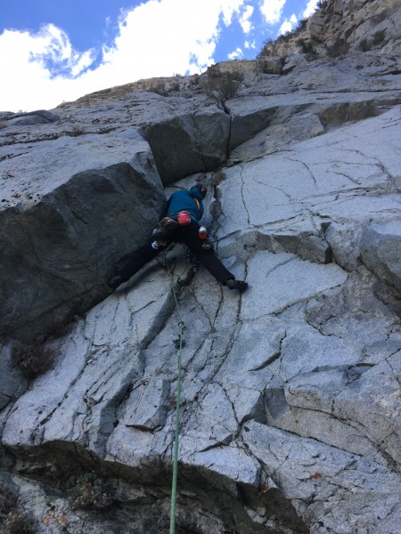
Starting up P1 of Godzilla's Revenge (matches up with the pic from Keith Leaman on Mountain Project):
[ Click to View Linked Image]
It's a bit more serious than it looks at first:
[ Click to View Linked Image]
[ Click to View Linked Image]
[ Click to View Linked Image]
I was seriously struggling on top-rope, yarding on gear as I cleaned it, maybe hanging a bit, before reaching the roof. I'm usually ok up to easy 5.10. It got a bit easier around the roof. Note the appealing finger/hand crack through the roof is very dirty/slippery and maybe moist, and it is easier a bit to the left. After clearing that roof and ambling up a bit, there is a belay station up and right with smashed hangers. From there, we chose a path back up and left following a line of bolts. Here is looking down from top of our P2 (a stance with double bolts). My pano skills leave something to be desired!
[ Click to View Linked Image]
P2 required some fairly gymnastic side-pulls through an overhanging bulge, but Kevin found a way that looked easier more to the left.
A short ways up P3, the line of bolts disappears, and a fresh bunch of flattened roots show a recently departed block about the size of a car. Up above that, it looks like a bunch of roofs, with more than a few loose. Here is a bit of a decision point for us:
[ Click to View Linked Image]
A better way to go from here is probably to cut out right across a sketchy loose bowling alley into better rock. We decide to use the light we have left to explore in the area rather than pushing into more looseness without a bolt kit. Heading down:
[ Click to View Linked Image]
[ Click to View Linked Image]
[ Click to View Linked Image]
[ Click to View Linked Image]
[ Click to View Linked Image]
We scouted some other lines:
[ Click to View Linked Image]
[ Click to View Linked Image]
[ Click to View Linked Image]
[ Click to View Linked Image]
At first I thought these patterns in the talus were from mineral formation patterns, but I think the striations were scars from sliding on weak layers in the rock as it broke away from the face above:
[ Click to View Linked Image]
We found a bit cleaner descent down the talus to the open area below:
[ Click to View Linked Image]
[ Click to View Linked Image]
And encountered a cool boulder that has been there longer than the mature tree leaning in the direction of Strawberry Peak (uphill right of frame):
[ Click to View Linked Image]
The other side:
[ Click to View Linked Image]
[ Click to View Linked Image]
[ Click to View Linked Image]
We managed to stay on a decent trail contouring around rather than the up and over bee-line approach we had employed in the morning:
[ Click to View Linked Image]
Overall, a pretty cool area with transitional vegetation, mature oak forests, and some giant acorns:
[ Click to View Linked Image]
[ Click to View Linked Image]
[ Click to View Linked Image]
But we had to leave the nice trail after a bit:
[ Click to View Linked Image]
[ Click to View Linked Image]
Just keep going ahead, a little to the right:
[ Click to View Linked Image]
Almost down to one of the ridges, with easier going:
[ Click to View Linked Image]
Cruisin' for a while!
[ Click to View Linked Image]
Still had our share of crawling, sliding, dirt-scrabbling before we got down to the road:
[ Click to View Linked Image]
All in all, not a major climbing achievement but a GREAT day enjoying the freedom of the hills. Thanks Kevin for putting the spot on my radar, and for having a great day with me. And thanks Keith Leaman for the sparse info and sandbaggy approach that helped make it a fun day (no sarcasm- legit happiness that we had enough info to point us in the direction and from there figured out what we needed). If you called that 5.9, I suspect your "was this an FA?" thread for Whitney was about as grim of a solo as it looked in your pics.
And Kevin! I saw your update in Mountain Project and you said you did that other thing in 1992? I thought you were going off of real beta from a couple of years ago, not an Alzheimer's delusion!
Pic for the thumbnail:
 NutAgain!
|
|
About the Author
NutAgain! is a trad climber from South Pasadena, CA. |
Comments
Gary
Social climber
Desolation Basin, Calif.
|
|
You've got to be a nut to climb that thing. Virgil Shields and Ben Chapman did it many years ago, maybe Ben will chime in here. Their report was quite entertaining.
|
|
NutAgain!
Trad climber
https://nutagain.org
|
|
|
Author's Reply
|
Mar 9, 2018 - 01:40pm PT
|
Yep DMT, one of these days the stars will align and we'll end up on an adventure together! Next few years I'll just be stealing short moments for adventures though.
|
|
Mungeclimber
Trad climber
Nothing creative to say
|
|
Nice one guys!! Choss, check. Adventure, check.
|
|
Gary
Social climber
Desolation Basin, Calif.
|
|
Choss, check.
That face makes choss look good!
|
|
jeff constine
Trad climber
Ao Namao
|
|
If I was with you it would have been to the summit!
|
|
mike m
Trad climber
black hills
|
|
Nice job that looks fun.
|
|
Levy
Big Wall climber
Calabasas
|
|
Cool stuff! I've been curious about that face for some time. when Angeles Crest Hwy was closed from the fires and slides, we were forced to go up to the crest via Upper big Tujunga Canyon Road and I would look up there and wonder.
Where is that amazing boulder found? Judging from the graffiti, it must be somewhat close to Camp Colby or the road. I gotta get up there soon.
|
|
Levy
Big Wall climber
Calabasas
|
|
Sweet! Thanks for the info. I'll post up when I make it over there.
|
|
NutAgain!
Trad climber
https://nutagain.org
|
|
|
Author's Reply
|
Mar 9, 2018 - 05:25pm PT
|
Ha, the graffiti put me off a bit too... but the spray paint is actually a trail label with trail directions to the peak - not a gang territory marker ;)
|
|
Friend
climber
|
|
I always make time for dew drops on spider webs, glistening on bay leaves and acorns
That is an awesome photo.
|
|
Reilly
Mountain climber
The Other Monrovia- CA
|
|
That face makes choss look good!
Roger that, Gary. I flew my plane up there to check it out BITD. I was totally like,
Are you phukking kidding me? And I think I have some bona fide choss cred. 🤪
|
|
tom woods
Gym climber
Bishop, CA
|
|
Looks sort of like fun.
That oulder looks classic though.
Someone told me that the that the Transverse ranges were among the fastest growing mountains in the world. Hence the broken rock?
|
|
ClimbingOn
Trad climber
NY
|
|
Awesome SoCal adventure climbing! I like it!
|
|
Fat Dad
Trad climber
Los Angeles, CA
|
|
Nice work guys. I've always meant to get back there and check that out. Not sure if it's faster, but it seems like it might be easier to approach from the opposite up Colby Canyon or the Josephine Peak fire road. I've mt. biked near there but have yet to check out the climbing.
|
|
Tarbuster
climber
right here, right now
|
|
|
|
Mar 10, 2018 - 08:09am PT
|
Good effort all around!
My curiosity is now satiated.
|
|
PhilG
Trad climber
The Circuit, Tonasket WA
|
|
|
|
Mar 10, 2018 - 08:36am PT
|
Stellar trip report, and amazing photos!
I remember going in there with Kieth one time. I recall the weather turned on us and we had to bail.
|
|
i-b-goB
Big Wall climber
Nutty
|
|
|
|
Mar 10, 2018 - 08:53am PT
|
Thx Again,
Let me take you down, 'cause I'm going to Strawberry Peak!
|
|
Ksolem
Trad climber
Monrovia, California
|
|
|
|
Mar 10, 2018 - 09:54am PT
|
You guys are nuts. Or more likely than not, nuts again ;-)
I recall the weather turned on us and we had to bail.
Saved by the bell...
|
|
rurprider
Trad climber
Mt. Rubidoux
|
|
|
|
Mar 10, 2018 - 03:36pm PT
|
Nice trip report, NutAgain. Glad you and Bat survived to tell the tale. We have shared your pain and sweat. We hiked in from Angeles Crest Highway 2 some years back and climbed Strawberry Roan, in 4 or 5 pitches, on the west side of the north face. Perhaps the fact that all the belay stances were beneath overhangs should have foretold of the loose, shifting nature of the climbing above. Fixed RURPs and loose pins were the name of the game. The climb was a fine adventure, but that north face is a house of cards.
Edit: TLP...the approach from Hwy 2 has a good amount of poison oak along the way to the Josephine Saddle.
|
|
TLP
climber
|
|
|
|
Mar 10, 2018 - 12:12pm PT
|
This adventure lacks one of the key elements of a California epic: poison oak! (Exhibit A: your excursion off of Hwy 156 in Monterey Co.) Normally it grows enthusiastically after a fire. Don't know what's wrong here.
|
|
yanqui
climber
Balcarce, Argentina
|
|
|
|
Mar 10, 2018 - 01:58pm PT
|
Burly!
|
|
Ezra Ellis
Trad climber
North wet, and Da souf
|
|
|
|
Mar 11, 2018 - 04:04am PT
|
Some serious choss,
Great tr none the less,
Thanks.
|
|
Keith Leaman
Trad climber
|
|
|
|
Mar 11, 2018 - 07:47am PT
|
"Feel the city breakin' and everybody shakin'
And we're stayin' alive, stayin' alive."
Thanks for the TR and photos, guys, brings back the memories. Looks like you had a great time slogging through the chaparral. I showed this TR to my wife and she said:
"That looks like a horrible approach! Why would anyone want to climb that?" I replied: "Because it was there...temporarily." :>)
Ray Palmer spent summers at Colby Ranch, and in 1967-69 we laid up several fiberglass whitewater kayaks there for our outdoor school in Steamboat. He and I (and as Phil mentioned - several others) doggedly tried several times to find enough solid rock to climb the whole thing. We did a few other one-to-two pitch routes to the right, placing no bolts.
When Ray and I finally did the whole route in 1968/69, he hammered a pin in the overhang, lowered off, and I led the rest of the pitches, running it out, using any solid placements as a belay station - no matter how short or long the pitch. There were sections of solid rock about half way up.
RE: the approach - I vaguely recall a trail from the Camp that followed the bottom of a shallow canyon (as opposed to the ridge) which led to the large boulder. We usually took a break there, warming up on several problems, then over a saddle to the left and up a talus area to the base. It didn't seem that long of a trail, maybe an hour and 1/2.
My former Geology prof - Dr. Dee Trent taught us that the San Gabriels were growing at a rate of two inches a year. I recently saw a plastic relief topo map, made in the early 1950s, that supported his assertion. The North face is loose and dangerous, but not without its rewards, so be careful if you climb there.
KL
|
|
PhilG
Trad climber
The Circuit, Tonasket WA
|
|
|
|
Mar 11, 2018 - 09:24am PT
|
Keith
I love the photo! It says it all. The shoes, the pants, the piton hammer.
We were so lucky to have climbed in those days.
|
|
Tarbuster
climber
right here, right now
|
|
|
|
Mar 11, 2018 - 10:38am PT
|
Yes, Keith, that is a five-star historically relevant photograph!
|
|
roy
Social climber
NZ -> SB,CA -> Zurich
|
|
|
|
Mar 11, 2018 - 01:08pm PT
|
Lots of fun!
The nice thing about stopping to take the great pictures on the way in is that it may be a very long time before anyone goes that way again.
Cheers, Roy
|
|
Tarbuster
climber
right here, right now
|
|
|
|
Mar 13, 2018 - 10:48pm PT
|
Say there, hey roy ...
I thought I might grasp the opportunity for a little thread drift and introduce myself to you.
My name is also Roy!
There aren't so many of us.
You, me, Roy Rogers, Roy Lichtenstein, Roy Batty from Blade Runner, and a few others ...
Cheers, Roy.
Roy
|
|
Batrock
Trad climber
Burbank
|
|
|
|
Mar 11, 2018 - 09:29pm PT
|
Hey Keith Leaman,
You talked of laying up kayaks at Colby. Did you ever kayak Big Tujunga? Back in the 90s I used to kayak Big T from Camp Colby down to the reservoir. I imagine it would have been pretty tough to do in fiberglass boats but I did run into one guy C-1ing Big T in the early 90s in a glass boat but he was doing the section above Colby which is not as steep and rocky.
|
|
JMC
climber
the land of milk and honey
|
|
|
|
Mar 11, 2018 - 10:15pm PT
|
The big boulder in Strawberry Potrero is a fine piece of rock, albeit a lonely one. It is ~ 4 1/2 miles to Strawberry Potrero via Colby Camp trail, and ~ 5 1/4 miles via the Josephine fire road/saddle route. The "Strawberry loop" via mtn bike (Josephine fire road - Strawberry potrero - red box, and then back to the car via the crest hwy, or San Gabrielino trail) is, as Sewellymon says, one of the finest bike loops in the San Gabriels.
I climbed there 2006-2009 following the closure of Williamson and the ensuing desperate search for another sad pile of choss: it took us 3 years to come to the realization that its size did not make up for the death blocks and rockfall and relatively long approach. A testament to the determination of the Mendenhalls!
Poison oak is there, mostly in the talus field, and along the southern/western (uphill) flank of the face. Some hideous gnats in mid-summer too.
|
|
Nick Danger
Ice climber
Arvada, CO
|
|
|
|
Mar 12, 2018 - 07:20am PT
|
A righteous effort, lads, and your TR is a wonderful morning read. It appears as if you have succeeded in finding one of those potential death choss piles just waiting for some gnat phart to bring the whole thing down. Also appreciate the wacking of the bushes, a time-honored way of proving that age is not necessarily correlated with wisdom.
About the stria on the rock face you show in one of the photos; that is slickenslides, a common feature of rock that has been faulted. Those occur on rock that is faulted at a shallow enough crustal level that all rock failure is brittle and not ductile. Since a certain amount of confining pressure is needed to create those stria, it doesn't happen as the rock is sliding down a surface such as in a rock-fall, but occurs in fault zones as one rock slides past another. The San Gabriel Mtns are probably riddled with faults if their rate of uplift is that high.
|
|
Nick Danger
Ice climber
Arvada, CO
|
|
|
|
Mar 12, 2018 - 07:21am PT
|
And a shout-out to the Roys of the world. Tarbuster is one righteous dude playing a hard hand with grace and style.
|
|
Batrock
Trad climber
Burbank
|
|
|
|
Mar 12, 2018 - 08:12am PT
|
That was a fun effort Scott, if there was an easier way in there it might be worth going back.
|
|
Tarbuster
climber
right here, right now
|
|
|
|
Mar 12, 2018 - 09:01am PT
|
If I understood Sewellymon correctly on the telephone yesterday, there is an easier way in. IIRC, longer, but more on trail, so maybe quicker?
Popcorn at the ready, here ringside: how about you adventure types out there start gloving up for round two!
(Trail description was likely described just up thread?)
|
|
Batrock
Trad climber
Burbank
|
|
|
|
Mar 12, 2018 - 09:22am PT
|
I hiked in several years ago in the late 90's and did a climb on the right side, I think we hiked the trail in from east of Red Box but it was still a bit of a trek. With the Tunnel Crag just up the road it's just not worth it.
|
|
Gary
Social climber
Desolation Basin, Calif.
|
|
|
|
Mar 12, 2018 - 09:24am PT
|
The best part is that when you do find a really good hold, you can take it with you!
|
|
Tarbuster
climber
right here, right now
|
|
|
|
Mar 12, 2018 - 09:55am PT
|
Bat said:
it's just not worth it. Ha ha.
Over the years that seems to have been the consensus, even if Scotty could beam you to the base, replete with full racks, ropes, and post-climb cocktails & companions of the fairer gender!
(... and maybe a trauma kit and an evac litter)
|
|
Reilly
Mountain climber
The Other Monrovia- CA
|
|
|
|
Mar 12, 2018 - 10:09am PT
|
This thread is too hilarious - SuperTopo at its most Cali-centric OCD best! But I gotta
commend yous guys for at least going for it. If yous guys want a heinous approach to
some world class choss I would direct you to Washington state. One of my FAs up
there still hasnt seen a second ascent (as far as I know) because the Park Service
closed the road. The lazy phuks up there wont even walk or bike up a road to a good
trail to bag a pretty damn good route!
|
|
Batrock
Trad climber
Burbank
|
|
|
|
Mar 12, 2018 - 10:26am PT
|
Ha ha.
Over the years that seems to have been the consensus, even if Scotty could beam you to the base, replete with full racks, ropes, and post-climb cocktails & companions of the fairer gender!
I have actually flown in there a few times when I was on the fire department to check out the face, this was years after i climbed it, like any good climber you forget or choose to forget how bad it was. After flying in a looking at it from the air I convinced myself it was worth another shot. This last trip in with Nutagain brought me back to reality. Give me another few years and I am sure i will be back. There really is some good rock there. The middle section of the base has about a 50 yard swath of super good rock that would yield a number of good one and two pitch routes as long as you don't go any further above into the crap rock above. It reminded me a lot of the base of Middle Cathedral, if you squint your eyes and stand way back. Most of the face however looks good from afar but is far from good.
|
|
Tarbuster
climber
right here, right now
|
|
|
|
Mar 12, 2018 - 01:15pm PT
|
There really is some good rock there. Yes, if one is highly selective, as you say. I'm not surprised to hear it.
That photograph from Keith Lehman and your picture just above illustrates this.
I grew up traipsing the San Gabriels with a boxy frame pack, learning to climb in Bailey Canyon, several years before I was of driving age.
Just me and my buddy Doug, Royal Robbins Basic Rockcraft, a chunk of misplaced Goldline, and our twerp-ish, adolescent physiques and craniums.
|
|
Gary
Social climber
Desolation Basin, Calif.
|
|
|
|
Mar 12, 2018 - 06:09pm PT
|
But I gotta
commend yous guys for at least going for it.
Virgil's motto was that you have to know your own backyard, that's why he talked Ben into going back there.
|
|
jbaker
Trad climber
Missoula, MT
|
|
|
|
Mar 12, 2018 - 06:22pm PT
|
Back in the 90s, Virgil told me about Strawberry (while we were bushwacking in to
check out some other loose face he'd seen from afar). I hiked in to check it out Strawberry, but it looked loose with scary pro and didn't seem worth hauling in a rack and a rope. Of course, Williamson was still open and there were stellar options that were new to me.
|
|
Tarbuster
climber
right here, right now
|
|
|
|
Mar 12, 2018 - 06:39pm PT
|
Williamson used to be called, or referred to as Eagles Roost, IIRC.
Before all the bolts sprouted, we used to just drive up there to smoke dope and look at her.
Did do a little ice bouldering and top roping there off of what was it, Highway 36, before it fell apart?
Placed my first bolt on a crag off of that road also, with Larry Loads. Total spinner. Retreated. WTF.
Maybe a couple of you hotshot survivors with fully functioning limbs can go up there and finish the project? Er, I mean prog or whatever contraction is used nowadays.
|
|
Batrock
Trad climber
Burbank
|
|
|
|
Mar 12, 2018 - 06:52pm PT
|
Williamson used to be called, or referred to as Eagles Roost, IIRC.
Before all the bolts sprouted, we used to just drive up there to smoke dope and look at her.
Thats what I always knew it as too. My dad took me climbing up there when I was 10 or 11. He used to climb there in the 1960's. It wasn't until Troy and i started working on the guidebook that we started or he started calling it Williamson Rock. I started going up there without my dad when I was 14 and started putting up routes on the main face and the summit block with whoever I could find that had a car.
|
|
i-b-goB
Big Wall climber
Nutty
|
|
|
|
Mar 12, 2018 - 07:17pm PT
|
Hey Roy,
Same, here is a scan of Eagles Roost from a photo on the backside of The Angeles National Forest map, pre-modern climbing up there. I went there early on too and even found a home made piton, I wonder if it was one of Keith or Ray's?
|
|
Spider Savage
Mountain climber
The shaggy fringe of Los Angeles
|
|
|
|
Mar 13, 2018 - 07:19pm PT
|
I did that approach once. Up the old fire break, pick up the old trail round the mountain over the ridges to Strawberry Meadow. Recon trip. Soloed a scary class 4 gully to the summit. Not recommended.
What if Strawberry became the new "Sport Craig" haw haw.
|
|
Tarbuster
climber
right here, right now
|
|
|
|
Mar 13, 2018 - 08:11pm PT
|
Good work Spider!
You the man!!!
|
|
Tarbuster
climber
right here, right now
|
|
|
|
Mar 13, 2018 - 10:51pm PT
|
Bailey Canyon, San Gabriel Mountains, lies just above a monastery in Sierra Madre, California.
It was a training ground for the Sierra Madre Search and Rescue Team, which at the time of the taking of this photograph, 1975, was said to be a rescue service of world renown.
I always found that hard to believe, however, there is merit to it. But here I was, cutting my teeth as a climber.
Strawberry Peak, had we known about it and actually got in there with our 40 m Goldline, probably would've killed us!
More on the Sierra Madre Search and Rescue Team:
From our original beginnings in 1951 as the first Mountain rescue Team in California, today's Team carries on the same tradition of service and excellence. The Team has been on search and rescue operations throughout the western United States and in Mexico and is well know across the country. Team members have also been - and continue to be - pioneers in the devolvement of new rescue equipment and techniques that are now being used world-wide.
http://www.smsr.org/index.php/about-us-topmenu-68/team-history-topmenu-67
http://www.smsr.org/
|
|
NutAgain!
Trad climber
https://nutagain.org
|
|
|
Author's Reply
|
Mar 14, 2018 - 05:15am PT
|
Nice additions all for some SoCal history! Spider, I spent some time pouring over that Mendenhall topo, and I'm having a tough time lining up features with my recollection. I'll have to go back and stare/compare in person!
What she calls the 4th class gully is probably the obvious easy looking line that just seems incredibly loose.
|
|
guyman
Social climber
Moorpark, CA.
|
|
|
|
Mar 14, 2018 - 10:01am PT
|
Sounds like a worthwhile trip... I can now pass by and not wish to go see what its like. I already know.
The big boulder looks stellar.
TFPU
|
|
Reilly
Mountain climber
The Other Monrovia- CA
|
|
|
|
Mar 14, 2018 - 10:20am PT
|
Ha-Ha, Tar! When we moved back to LaLa Land I ran up to Bailey Cyn and went up
the drainage until it got really nasty and angled up and right and hit the trail about a
quarter mile from Georges cabin site. I dont recommend that route, especially in
a T shirt and short shorts. 5.9 dirt and very unfriendly flora. 🤡
|
|
Gary
Social climber
Desolation Basin, Calif.
|
|
|
|
Mar 14, 2018 - 10:29am PT
|
Spider comes through with the goods. NutAgain, the Mendenhall's routes have probably all fallen off, that's why you don't recognize them?
Tarbuster, did you start at the old foundations? I've had opportunities to go canyoneering Bailey many times, but the thought of all the PO holds me back.
|
|
Batrock
Trad climber
Burbank
|
|
|
|
Mar 14, 2018 - 01:10pm PT
|
Thats the same Topo RJ Secor gave me. I think I must have done Strawberry Roan or something very near it when I climbed the face in the late 90's.
|
|
looking sketchy there...
Social climber
Lassitude 33
|
|
|
|
Mar 14, 2018 - 02:36pm PT
|
I've looked at the north face a few times, while mt. biking and making a loop along and around the perimeter of the Peak. You ride/hike right past the cool boulder. Why you would not choose to hike in on one of the trails is beyond me.
Cool photos and TR.
|
|
Batrock
Trad climber
Burbank
|
|
|
|
Mar 14, 2018 - 02:40pm PT
|
Why you would not choose to hike in on one of the trails is beyond me. Because we thought there was a trail from Camp Colby, otherwise we would have taken the other trails. Early ascents talked about taking a trail from Camp Colby but when we got there and looked around whatever trail did exist was probably grown over decades ago.
|
|
Tarbuster
climber
right here, right now
|
|
|
|
Mar 14, 2018 - 06:12pm PT
|
Reilly, Gary!
Fun to converse with people that have experience with Bailey.
As soon as Doug Munoz and I could drive, it was Stony Point and Mt. Rubidoux, and even before that, we'd have parents leave us at Joshua Tree or Tahquitz for short spells, starting in fall of '75 & early'76. So I probably haven't even been up to the site of our climbing since the summer of '75.
I don't remember any cabins or foundations at the mouth of the canyon or in the canyon proper, not before accessing the actual climbing area we used. Doug used to talk about "the cabin", which I believe was accessed from a side trail which branched out of the canyon to the right, and was positioned above what we called the third waterfall.
My recollection goes like this: from the monastery, a small trail leads up to the first waterfall, which any tourist can get to. There is a scrambling route skirting the left side of the first waterfall, which is fairly tall and sits at the back of what could almost be described as a grotto. This first waterfall often actually had water cascading down in freefall, though not with much volume. This first waterfall is maybe 30 or 40 feet high.
I think even into the late 90s there was a large dangling tree root which could assist the bit of scrambling which would take one above and left the top of the first waterfall.
The next section required getting up out of the canyon something like 30 vertical feet on the right-hand side. I went there with my nephew in the late 90s/early 2000's, and the slope there was so unstable we turned around.
After that, one would descend back down into the canyon and there used to be a very large boulder which you could either tunnel beneath, or alternatively do a fourth class or even low fifth class scramble right up the face of the boulder. Memory fails me, but it may be that the skirting of that choke point was what we would sometimes be doing up out of the canyon on the right side, to avoid said boulder, but I don't recall.
So after getting up on the right side and either avoiding that big boulder, or additionally burrowing beneath it or climbing the face of it, as the case may have been in terms of sequence or the correct relationship of those features, one would arrive at the second waterfall, which was almost always dry and was a very solid piece of granite, and flute-shaped.
There was a layback crack to the left, and I recall a way around further up and left to skirt that difficulty, so one could get to a single expansion bolt which the search and rescue placed at the top of the second waterfall.
From there we would top rope and rappel and so forth, all on the second waterfall. I'm going to say the second waterfall was about 40 or 50 feet high.
The third waterfall I never visited, but Doug and his father once went up there and described it as being possibly taller than the first two, near-vertical, more broken, maybe a bit loose, and they scrambled/climbed partway up that as a reconnaissance.
Apparently the cabin lies above the third waterfall. I may have been to that just once, using the trail that branches out of the canyon on the right, (which Reilly bushwhacked up to) and was disappointed to see that it was nothing more than a foundation.
 Gary, aren't you the guy that printed up those Super Taco T-shirts some years ago? I still have mine! Gary, aren't you the guy that printed up those Super Taco T-shirts some years ago? I still have mine!
|
|
jeff constine
Trad climber
Ao Namao
|
|
|
|
Mar 14, 2018 - 04:53pm PT
|
Batrock and I already starting bolting it!
|
|
rincon
climber
Coarsegold
|
|
|
|
Mar 14, 2018 - 05:28pm PT
|
Because we thought there was a trail from Camp Colby, otherwise we would have taken the other trails. Early ascents talked about taking a trail from Camp Colby but when we got there and looked around whatever trail did exist was probably grown over decades ago.
Quick Google search shows they re-routed the trailhead. No longer starts at Colby Camp. Now starts directly off the Upper Tujunga Rd.
Nothing has been rerouted.
The trail starts from the parking lot by the bridge just as it always has. I've hiked it a dozen times.
The bridge is 1/2 mile before Camp Colby.
IMO the best approach to the base of the climbing wall is from Hwy 2 Colby Canyon trail up to Josephine Saddle then keep going on the trail until it gets close to the wall and viola. Alternately, from Josephine Saddle you could head up the west ridge use trail and drop down to the north face near the top. No need for bushwacking.
|
|
tamarahastie
Trad climber
Flagstaff, AZ
|
|
|
|
Mar 15, 2018 - 12:44pm PT
|
This great- love the good ol' so cal bushwacking to choss. Very appreciated trip report.....need more of this asap. :)
|
|
Elmo Te
Trad climber
LA, CA
|
|
|
|
Mar 17, 2018 - 03:37pm PT
|
I first hiked Strawberry as a kid from Camp Colby in the winter with snow on top and hibernating ladybugs in the trees. Later it was a RCS tradition to go there once a year as a group trip, a tradition long dead. Ben and Virgil branched out from that as I recall to do their own exploration.
Keith Lehman, when were you at Citrus? Did we know each other? Dee's pithy quotes and many great trips are some fond memories.
|
|
Toadlick
climber
Los Angeles
|
|
|
|
Nov 18, 2018 - 08:48pm PT
|
Has anyone made it out to the boulder specifically yet? I've been eyeing that and other boulders in the meadow for years on my Strawberry Peak loop runs. With the recent fires on the coast and the gate closure at Horse Flats it seems like now might be the time...
Keith, do you have any recollection on which problems you all were warming up on? I'm assuming it was mostly on the slabs to the left of the small dihedral-like feature left of the "Trail" painting, but would love any info you might be able to provide!
I'll post up what we manage to get done, if anything at all!
Andy
|
|
|
 |
|
Recent Trip Reports
- The Kohala Ditch Trail: 36ish hrs on foot... to and from the headwaters. [5 of 5]
May 31, 2019; 11:57pm
- A Winter Traverse of the California section of the PCT Part 8
May 31, 2019; 11:18pm
- Supertopo,A trip report for posterity
May 31, 2019; 11:00pm
- Balch Fest 2013. Two Days in and Around and On The Flake. The Official Trip Report
May 31, 2019; 10:57pm
- TR: My visit to the Canoe
May 31, 2019; 10:24pm
- Death, Alpine Climbing, The Shield on El Cap
May 31, 2019; 4:07pm
- Andy Nisbet (1953-2019)
May 31, 2019; 2:11pm
- Drama on Baboquivari Peak
May 31, 2019; 1:19pm
- Joffre + The Aemmer Couloir: ski descents come unexpected catharsis [part 2]
May 31, 2019; 7:45am
- Lost To The Sea, by Disaster Master
May 30, 2019; 5:36am
- My Up And Down Life, Disaster Master
May 29, 2019; 11:44pm
- Halibut Hats and Climbers-What Gives?
May 29, 2019; 7:24pm
- G Rubberfat Overhang-First Ascent 1961
May 29, 2019; 12:28pm
- Coonyard Pinnacle 50 Years Later
May 29, 2019; 12:24pm
- Great Pumpkin with Mr Kamps and McClinsky- 1971
May 29, 2019; 12:02pm
- View more trip reports >
|