Snake Dike, Half Dome 5.7 R |
||
Yosemite Valley, California USA | ||
|
Google Maps Overview
|
|
|
The GPS coordinates for this route are shown below. See the GPS Marker Legend at right for details on each marker. Click on the Marker to see the actual GPS coordinates. Approach
The 6-mile approach gains approximately 2500 feet of elevation and is extremely strenuous. Start early and plan for at least 3 hours of hiking. Park at Curry Village and either walk or take the shuttle to Happy Isles. Follow the John Muir Trail for one mile to the Mist Trail. Follow the Mist Trail for 2.1 miles to the top of Nevada falls and again pick up the Muir Trail. After about 0.75 miles... BUY Yosemite Valley Free Climbs and read the rest this approach and much more.Descent
Allow 3-4 hours for the 9-mile descent. From the summit, descend the cables. The cables are in place year-round. During the winter and spring the uprights are removed, but the cables are still easy to descend. Continue on the Half Dome Trail until it joins the Muir Trail, which leads back to Happy Isles.
|
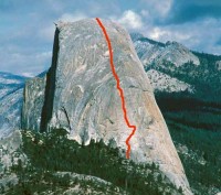 Photo: Chris McNamara
|
Home | Climbing Areas | Free
Topos | Guidebooks | Route
Beta | Forum | Trip Reports |
Photos | Articles
Links | Terms | Privacy | FAQ | Contact
| About Us
Climbing Areas
Rock Climbing Yosemite |
Big Wall Rock Climbing Yosemite |
Rock Climbing Tuolumne |
Rock Climbing Sierra
Rock Climbing Red Rocks |
Rock Climbing Southwest |
Rock Climbing Zion |
Rock Climbing Tahoe |
Climbing Alaska
All trademarks property of their respective owners
How can we improve SuperTopo? Got feedback?
![]() Let us know!
Let us know!
Climbing is dangerous. Climb at your own risk.