Zodiac, El Capitan A2 5.7 |
||
Yosemite Valley, California USA | ||
|
Google Maps Overview
|
|
|
The GPS coordinates for this route are shown below. See the GPS Marker Legend at right for details on each marker. Click on the Marker to see the actual GPS coordinates. Approach
From El Capitan Meadow, pick up the distinct trail that starts 300 feet west of El Capitan Bridge. Follow the trail to a large clearing. When facing the wall, walk at 10 oclock and pick up the climbers' trail that eventually leads to a point 200 feet in front of the toe of the Southeast Buttress and the start of the Nose. From here, the trail diverges to skirt either the base of the Southeast Face or Southwest Face. Its about a quarter mile and a 10-15-minute walk from the road to the toe of the Southeast Buttress and the start of The Nose. From there, it is an additional 20-30 minutes to reach the start of Lurking Fear or Zodiac.Descent
The 2-3 hour East Ledges Descent is the fastest, most convenient way to descend from El Capitan. It spares your knees the long hike down either the Yosemite Falls Trail or Tamarack Flat Trail.From the summit of most routes, hike east, staying 100 feet from the edge of El Capitan until you reach a long and distinct 30-40-foot-wide drainage just below the Zodiac finish. (For the Lurking Fear/West Buttress Finish, begin by hiking away from the edge and east until you escape slabby and brushy terrain. Then turn and head down and a little east back to the edge of El Capitan.) Follow the drainage down until 80 feet before a 2,000-foot drop-off into Horsetail Falls (often dry). Enter the manzanita bushes on a well-worn trail that after 5-10 minutes will hug the left wall. Continue along the wall until bushes end and scramble down 3rd-class terrain for about 100 feet to a ledge that is roughly perpendicular to The Wild Dikes, a south-facing black wall streaked with white. Read the following text while referencing the descent topo in the book "Yosemite Big Walls: SuperTopo": For rap routes A and B, move down 15 feet of 4th class and cut right (south) across a 20-foot wide drainage gully. Walk/slide down the right side of the gully for 30-50 feet. Exit onto the south (right) shoulder and cruise down 40 feet to a ledge. For rap route A, continue toward the edge and down a 20-foot 4th-class section to a tree wrapped with slings. For rap route B (the only route you can rap with one 60m rope), head left and down 30 feet of scree, then move right over exposed 4th-class rock. Work right, through a bush, to a 4 x 6 flat ledge with a small tree. Rap route C (see topo) is not recommended. From the base of the rappels, head east down multiple 3rd-class sections joined by faint trails. Eventually, a defined trail will emerge. Follow it down to a boulder strewn drainage, immediately crossing to a trail paralleling the drainage for 300 feet before it breaks off into the trees to the Manure Pile parking lot, about one mile from El Cap Meadow. If youre caught in a storm or descending at night and are unfamiliar with the East Ledges descent, take the tedious, 4-5-hour Yosemite Falls Trail descent instead. Pick up the Falls Trail from the summit of El Capitan (see map page 42 of Yosemite Big Walls). |
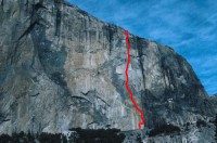 Photo: Chris McNamara
|
Home | Climbing Areas | Free
Topos | Guidebooks | Route
Beta | Forum | Trip Reports |
Photos | Articles
Links | Terms | Privacy | FAQ | Contact
| About Us
Climbing Areas
Rock Climbing Yosemite |
Big Wall Rock Climbing Yosemite |
Rock Climbing Tuolumne |
Rock Climbing Sierra
Rock Climbing Red Rocks |
Rock Climbing Southwest |
Rock Climbing Zion |
Rock Climbing Tahoe |
Climbing Alaska
All trademarks property of their respective owners
How can we improve SuperTopo? Got feedback?
![]() Let us know!
Let us know!
Climbing is dangerous. Climb at your own risk.