Geronimo, Jackrabbit Buttress, South Face 5.6 |
||
Red Rocks, Nevada USA | ||
|
Google Maps Overview
|
|
|
A map of the general Red Rocks, Nevada USA area is shown below. No GPS coordinates for this specific route are available at this time. Approach
From Pine Creek Trailhead, hike on the main trail down the hill and up the main trail up Pine Creek. Go past the Fire Ecology Trail (two entrances, it is a short loop), past an unnamed trail on the left, to the main Arnight/Knoll Trail (just past the prominent concrete foundation of the old homesteadabout 15-20 minutes from the car). Cross the creek, go right for 150 feet, then follow the nicely graded trail left and up the far bank. Hike on the trail for about 10 minutes, then take the right trail heading toward Cloud Tower. The first prominent trail on the right is the approach to Rose Tower and the Northeast Face of Jackrabbit Buttress (the descent trail from Rose Tower intersects earlier, but it is hard to see from the main trail). To continue on to Crimson Chrysalis, Geronimo, or anything up the main Juniper Canyon (Brownstone Wall, Rainbow Wall), stay on the left trail. After another few hundred yards, a trail heads left across the rocky wash toward Cloud Tower (Crimson Chrysalis, etc.), while the main Juniper Canyon trail heads up the canyon. At the mouth of the canyon, a small use trail heads up and rightthis is the approach for Geronimo.Descent
Rap from the top with two ropes. Once at the big ledge after the first rap, stow one rope and rappel four more times with a single rope, using care to keep the rope out of the cracks. Rope snags are common, and if needed, you can use the second rope to re-lead and retrieve the rope. The last three raps are from trees or slung chockstones, and extra long webbing may be needed to replace old webbing.
|
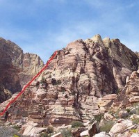 Photo: Greg Barnes
|
Home | Climbing Areas | Free
Topos | Guidebooks | Route
Beta | Forum | Trip Reports |
Photos | Articles
Links | Terms | Privacy | FAQ | Contact
| About Us
Climbing Areas
Rock Climbing Yosemite |
Big Wall Rock Climbing Yosemite |
Rock Climbing Tuolumne |
Rock Climbing Sierra
Rock Climbing Red Rocks |
Rock Climbing Southwest |
Rock Climbing Zion |
Rock Climbing Tahoe |
Climbing Alaska
All trademarks property of their respective owners
How can we improve SuperTopo? Got feedback?
![]() Let us know!
Let us know!
Climbing is dangerous. Climb at your own risk.