Nickers
Trad climber
San Diego, CA
|
 |
Does anyone know the conditions up there, have they gotten hit with a lot of snow with all these storms??
|
Coby
Mountain climber
CA
|
|
Any information on current conditions?
|
NotIt
Trad climber
SF, CA
|
|
Conditions on May 21 2009:
Couloir is firm before 9 or so - after that you don't want to be on it unless you sincerely enjoy knee to hip-deep postholing.
Intermittent snow between Lower Boyscout and Upper Boyscout. Iceberg is fully snowed in with a hole cut for getting water.
It's getting hot up there!
|
Eric McAuliffe
Trad climber
Alpine County, CA
|
|
anyone been up there yet this season. Snow conditions??? any input helpfull!
E
|
jsb
Trad climber
Portland
|
|
Yes, the gully below the E-ledges is full of thick, tall brush... pretty much impassable.
|
fredmlooper
Mountain climber
Dallas
|
|
I have a quick question, in looking at the E-Ledges, it appears you only gain maybe 50-75 feet elevation and it takes you up to the north before switching back to the south in gaining that elevation. Is there a reason to climb the ledges versus following the base of the cliff up to where you exit the ledges other than the excitement from the climb?
|
10b4me
Social climber
Lida Junction
|
|
The problem is at the notch. This is where you turn south(left) to go to Whitneys' summit. The rock is fourth class, and if it is icy you will want an ice axe, crampons, and maybe a rope.
If the rock is dry, it's not too bad.
|
Zander
climber
|
|
I did this route with my wife who is not a climber. Both of us are old geazers. If you go late season and there is no snow at the turn above the first chute you probably won't die. There is one "4th class" section, about 10 feet or less, right after you get out of the initial scree gully and turn the corner. For non-climbers this is pretty thin. I had a 7 mil rope with me but we didn't use it though maybe we should have. After that it is helpful to have one person who is pretty good at route finding. We still had to tiptoe across some snow covered ledges. On the return there were other people who climbed down the harder, left looking up, side of the upper chute who sent down some big rocks. This was pretty freaky and I talked them into going down the lower scree gully with us as a big group to minimize this danger. Otherwise the upper chute is really fun and at times exposed class three.
As Chris says in the topo, if one person of the group has some mountain sense this route is totally do-able and, I think, really fun. Of course I think endless scree is an adventure.
|
Chris McNamara
SuperTopo staff member

|
|
I have not climbed the keyhole route. But the Mountaineers route is only dangerous if you are not prepared for the conditions. If there is snow/ice then its important to bring crampons, ice axe and maybe a rope and slings to rappel.
|
fredmlooper
Mountain climber
Dallas
|
|
I am gathering beta on the Mountaineer's Route. I'm seeing a lot about the top of the gulley, "pro climbers falling 1,000' plus", a lot of deaths, etc and I am concerned. I have climbed Long's via the Keyhole Route with Class 3, Class 4 climbing with no problem.
I would like to hear from someone who has climbed both and give a comparative summation of Mt. Whitney's Mountaineer Route compared to the Keyhole Route of Long's Peak.
|
hopkinsed
Mountain climber
San Diego, CA
|
|
Well my first experience in the Whitney valley did not lead to a summitt but that was only due to timing (not quite enough time allotted due to a 5 hour drive up and back from San Diego). Plus my partner refused to do the ledges via headlamp. Well the one thing that I want to note for beta here is that the North Fork Approach to Upper Boy Scout Lake has a few tricks that are not covered in the guidebooks:
1. If early season this may not apply, but if late season, look for a cut left (cross the creek) soon after entering a clearing above pine trees to a (dry when I did it) creek bed that serves as a trail for most of the creek basin ascent. I ended up following the guidebook's recommendations to keep to the right of the creek and ended up paying for it in bushwhacking all the way up.
2. The ledges section involves one or two tricky moves if you have heavy backpacks (as we did). If you come to a section that looks like you can go up to the left towards a pine tree, or keep going right ... keep going right. A little ways down will be an obvious scramble up and then the trail heads up and back to the left way up to the cliffside.
3. From here the trail follows the edge of the cliff basically up to some trails that lead to Lower Boy Scout Lake.
4. After you pass the shady pine section to the left of Lower Boy Scout Lake (assuming you take the left route) keep towards the creek rather than venturing into the boulder field. I ended up following a definite trail with cairns that took me way up to the cliffs to the left that I am still not quite sure where it was heading, before I finally realized there is a much easier (and direct) route up the granite slabs right at the creek. Meandering up the slabs criss crossing the creek at times gets you to the base of Upper Boy Scout Lake.
5. From Upper Boy Scout there's a trail to the left up over a high section that leads to Iceberg Lake. It's 5 1/2 hours from Upper Boy Scout to the Summitt and back (beta from a group we passed). We ended up just camping out at Upper Boy Scout and skipping the summitt attempt (unfortunately we had to get back for jobs the next morning). Next year I'm definately slating another day or two for this!
|
tahoerob
climber
Lake Tahoe, NV
|
|
I'm very interested in checking out the "Mountaineer's Route" this summer. I'd like to overnight at Iceberg Lake. I understand that a permit is required. However, when I called the field office down in Lone Pine, no one could give me a straight answer on what I needed.
One person said I didn't need a permit. Another said I did, but didn't know which one. Another said I had to apply for it the day before going in and that I could not apply ahead of time. Another said I could apply ahead of time, but it wasn't the same lottery as the main Whitney lottery and she didn't know how to do it. Seriously.
Can anyone who has done this route and received the proper permit to camp in the backcountry give me a little guidance. It would be much appreciated.
Thanks!
|
aMountainclimber
Mountain climber
Seattle, WA
|
|
Well, the climb is 2,000 feet not 1,000.
I would consider this a classic from a historical perspective. I marvel at John Muir starting his approach from Independence.
Winter and summer are very different. I find both to be fantastic training and conditioning climbs.
Another excellent reason to climb this is if you are planning to do one of the technical routes and use this as a down route, it is really better to get it sorted out by going up it at least once.
|
Justin Black
Mountain climber
Bishop, CA
|
|
On Friday June 16th, 2006, I climbed the Mountaineer's Route in support of a group of people donating $5,000 each to support the Rowell Fund for Tibet, administered by International Campaign for Tibet. Also climbing in support of the donors were Conrad Anker and Peter Croft, and John Ackerly, President of ICT who took time from their busy schedules to join the effort. All together, the climb raised $35,000 for Tibetans working in the communication arts whose activities benefit the Tibetan culture, society, and ecology. Excellent guiding services and great backcountry meals were provided for the group by SP Parker of Sierra Mountain Center in Bishop.
I wish to extend my thanks and congratulations to all involved!
On the way up the main gully, there was snow on about 3/4 of the route which softened very early in direct sun, but the last few hundred feet at the top of the north face above the notch was firm and made for great step kicking. The descent down the snow in the gully was wet and soft, but in general the descent was a breeze with some great, albeit bumpy, glissading. On the approach up the North Fork, snow can be avoided almost entirely until just below Iceberg Lake. A warming trend has been in effect for the last few days, so expect things to melt out fast.
|
kevin
Advanced climber
Bishop, CA
|
|
well, it all depends on conditions , We climbed this route in the spring under snowy conditions . It quickly became a clasic alpine mixed climb with crampons on rock and Verglass placing ice screws in the gully and rock protection because one slip down the gully on that ice and your a gonner. Just to make it more fun climb with full pack and then desend via the trail for a nice 3 day round trip.
|
|
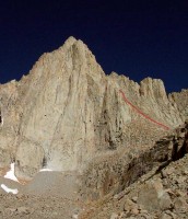
The route disappears behind the ridge and follows the gully to the summit.Photo: Chris McNamara
|
*What is "Route Beta"?
It's climber slang for information or tips on a route as in, "what's
the beta on that route?" As a service to fellow climbers we ask SuperTopo
guidebook users to post tips and updates to this website if they have relevant
information to share after a climb.
| | | | | | | | | | | | | | |