Johnny See
Mountain climber
Park CIty
|
 |
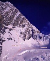
This is a stellar route. It might not be the Cassin Ridge but an "easy" way to the summit? Come on, it's Alaska. Be prepared. Anyway, here's some beta:
1) It will take you about 35-45 minutes to reach the bergschrund from camp near the airstrip. This season the first crevasse encountered in the upper basin may give you trouble; I stepped through the bridge.
2) Use care in the upper basin. After a storm slide tracks from the west face of Huntington reached well into the basin itself and went as far as the large crevasses at the top of the icefall.
3) Although Supertopo says it is 700 of snow climbing to reach the ice, we rapped almost all of it in a storm on the way down and the distance is closer to 1400 so plan accordingly.
4) The ice crux is definitely the first pitch. Near the top there is a section of overhanging ice that is quite strenuous.
5) Although that is the crux, expect several more pitches of steep, calf-burning ice with no rests.
6) Be prepared for a total lack of stances in the couloir itself. All belays are semi-hanging and extraordinarily uncomfortable.
7) We completed the couloir in approximately 7 60m pitches, not 12 as the book indicates.
8) The last pitch is mixed leading to a two wire fixed anchor. Above this is a traverse up to a bolt, then down and across easy snow about 30m to screws directly below the cave.
9) The cave, contrary to the topo, is not on the route but about 60 above the route. We were the first party up there this season and chopped out everything that could be chopped. In so doing we managed to get about 2/3 of a bibler set up on it. There are no fixed anchors in the cave but it is well sheltered and reasonably comfortable, now.
10) Immediately to the climbers right of the cave is the gully that leads up and left to what the topo calls a decent bivy on the arête. First, it is not 60 to this bivy but more like 60m. Second, while it may have been a bivy in the past it is not now. In fact it is a hard ice arête into which we put a thread on the descent. Do not waste your time going up there to bivy. Its the cave or I dont know what, maybe the summit ridge?
11) There are several ways to go around and right to the upper part of the mountain on the route from the belay below the cave. We chose the highest snow/mixed traverse at roughly the climbers 2:00 from the belay below the cave. It is moderate mixed with some fixed gear. Keep traversing until a small stance, and the next pitch heads up and left past a fixed angle from there until you can clearly see both the summit and the summit boulders.
12) The summit ice field boulder is really a collection of boulders/walls. Just weave through them until you can head straight up steep snow to the summit ridge.
13) The summit ridge has crevasses, be careful!
14) The final 40 vertical/over hanging snow wall on the ridge can be easily traversed on the right end. There is a small crevasse to be careful of but otherwise dont worry about it. Its ice and easily protected there.
15) The descent:
a. Downclimb to a thread which allows you to rap the vertical snow wall
b. There is a dead manned picket at the top of the summit ice field
c. Rap from there to a thread at a sharp rock on the climbers right/skiers left of the summit ice field below some shallow flutes
d. Rap from there to any number of anchors in and around the boulders but get as low as possible even if it means making a shorty to get threads directly below the boulders.
e. Rap from as low as possible (preferably threads below the lowest boulders) straight down to cordelettes slung around a large pointy boulder. This will be out of sight and to climbers left/skiers right of the way you came up. It is critical you find this anchor.
f. THIS IS THE CRITICAL RAP SO TAKE YOUR TIME: rap from the two cordelettes around the boulder gradually to climbers right/skiers left until you reach a steep, blank wall. Continue over the blank wall until you see an obvious snow/ice arête. Take care to keep trending toward climbers right/skiers left - Going straight down the blank wall will leave you dangling at the end of the rope with no anchor!! Once you reach the arête you are home free as you have landed on the decent arête bivy described in the topo (in fact you are also directly above the cave bivy but it would be hard to reach it because of the roof). From hear a 60m (not 60) rap will take you to a horizontal crack with a ring angle. You can build an anchor and either begin traversing back to the top of the couloir (you should be on your tracks) or climb down, over and up back to the cave if you need to bivy again.
g. Once youve reached the top of the couloir the descent is time consuming but straightforward. Use caution with existing treads though: I broke one easily on the climb up.
h. We had a storm with massive spindrift and felt it safer to rap most of the way to the bergschrund. There are anchors in the rock but they are squarely in the drainage line.
|
|
An overview of the line.Photo: Joe Puryear
|