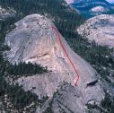
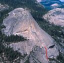
South Face, North Dome 5.7 |
||
Yosemite Valley, California USA | ||
|
Avg time to climb route: 5 hours
Approach time: 2-3 hours Descent time: 2-3 hours Number of pitches: 8 Height of route: 700' Overview
This climb has long been overlooked. Though not quite as classic as its neighbor, Crest Jewel, this route offers quality moves worthy of the long approach. A large arch at the start is followed by spectacular moving onto the clean South Face. Thin cracks and friction moves lead to 300' of sustained liebacking. Most climbers link up Royal Arches with this climb for 20+ pitches of great climbing.
Photos
- View all 6 photos of South Face as: Thumbnails | Slideshow
Climber Beta on South Face
Which SuperTopo guidebooks include a topo for South Face?
Find other routes like
South Face
History
Wally Reed and Mark Powell were the two best Valley free climbers during the late 1950s. In the spring and summer of 1957 they got together and established five exceptional routes. Among these is one of the classics of today, the South Face of North Dome. Reed described the climb later in his matter-of-fact style. After three pitches of easy friction and lieback climbing we were at the base of a 15-foot overhanging wall which diagonals to the left across the lower third of the face. Three sixth-class pitons overcame that problem, which was followed by two moderate friction pitches. Soon the pair arrived at the crux, a right-facing open book that stretched upward out of sight. Reed again: Arranging a belay stance from a lieback position 100 feet up was difficult, as was the single crack which continued to a small ledge above and which was partly filled with dirt and grass. Thirty feet beyond the ledge all cracks terminated. By placing a piton at his feet, Mark was able to make a difficult pull-up and a delicate friction step to easy scrambling and the summit. It took us about six hours. Reed and Powell had accomplished the route in superb style, using only three aid placements. Other climbers of the time would have used many more. Because of the gruesome approach, no one repeated this route for more than three years. One cool October morning in 1960, I was restless, eager to do something different from the usual routine. I talked Mort Hempel and Irene Ortenburger into trying the route, and soon we were staggering up the North Dome Gully, complaining just as much as Reed and Powell must have. But, unlike them, we still had the climb ahead of us on the same day, and didnt rope up until early afternoon. We somehow avoided the aid on the 15-foot overhanging wall (it seemed not that overhung and only wild 5.7, so perhaps we discovered a variation), and then raced the sun to the summit. The liebacks at the top proved thrilling indeed, but the descent was not. Steve Roper Strategy
An alpine start is mandatory. A 60m rope allows linking some pitches and is needed to avoid simul-climbing on Pitch 4, which is 180 feet.There are three distinct cruxes. Pitch 3 is the routefinding crux (most climbers are lured by off route slings and go too high). After this the routefinding is pretty easy. Pitch 4 is the psychological crux as you must travel a long ways on 5.6 runout slab. Pitch 7 is the endurance and technical crux with a section of insecure 5.8 liebacking. Overall, the route is sustained with almost every pitch involving at least 5.7. Retreat
Carry two ropes to retreat. From Pitches 1 and 2 there are slings on trees but after that you will have to leave gear.Approach
Access North Dome from Porcupine Creek Trailhead, by climbing Royal Arches, or by reversing the North Dome Gully (see North Dome Gully page). Porcupine Creek Trailhead is the fastest and most popular approach. However, if you climb fast, the Royal Arches option makes for a combined total of 24 classic pitches. Both approaches are long and make for a demanding day.Approach from Porcupine Creek Trailhead
This approach is about 5 miles long and is flat until it descends to the base of the dome. Park at the Porcupine Creek Trailhead (1 mile east of Porcupine Flat or 4.5 miles west of Olmstead Point). Hike the trail for 4 miles to just before North Dome. Leave the trail and hike cross-country down the drainage on the west side of the dome. Traverse across when steep slabs are encountered. When you hit the large ramp system, hike up. You may encounter bad bushwhacking. Contour around when possible to a ramp leading to the base of the South Face route, which is marked by the huge obvious dihedral. Note: This approach is only viable when Highway 120 (Tioga Road) is open, usually between June and November, depending on the snow year.Approach from Royal Arches
After climbing Royal Arches, head east on a climbers trail toward Washington Column. At the slabs, walk up and slightly right over the slabs aiming for the lower of the two obvious terraces with trees at the base of North Dome. Skirt a large rock ridge along its left side and gain the base of the dome at the eastern end of the terrace. The route is the obvious left-facing dihedral. From the top of Royal Arches, the approach is 0.8 miles long and gains 500 feet of elevation.
Everything You Need to Know About
Yosemite Valley
Search the internet for beta on
South Face
|
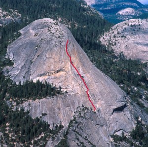 The South Face stays in the corner Photo: Chris McNamara
Other Routes on North Dome
|