drunkenmaster
Social climber
santa rosa
|
 |
Mt Tam Bouldering - Fall 2012
|
drunkenmaster
Social climber
santa rosa
|
|
Mt Tam Bouldering - Fall/Winter 2011
http://summitorplummet.blogspot.com/2011/12/mt-tam-fall-2011.html
|
drunkenmaster
Social climber
santa rosa
|
|
*East Bloc/ATF Boulder + Bay View Boulder (on right/south side below road and small turnout with view of bay) + East Bloc/ATF Boulder (on left/north side across from turnout in the trees just up the hill - 1 min [about 0.9 miles east of Rock Springs on East Ridgecrest]
*Lakeview Boulders - off Lakeview Trail which is on East Ridgecrest just west of the East Peak. Hike the trail to the north/east to the trailside boulder that has a few problems then hike downhill to the rest from there!
|
bigbear
Boulder climber
berkeley ca
|
|
Where is the ATF boulder located? Tried twice to find it but not luck, any help?
|
drunkenmaster
Social climber
santa rosa
|
|
YOUTUBE vid of Kenny Ariza doing almost every problem on his classic roadside ATF (Alcohol Tobacco and Forearms) Boulder, including the mega classic ATF Traverse in reverse (V6)!
http://www.youtube.com/watch?v=jAlstJck_-Q
and his testpiece of the mountain - Procrastination (V7 sit)
http://www.youtube.com/watch?v=tPt7id9q3Nk
|
drunkenmaster
Social climber
santa rosa
|
|
heres a vid of the classic old school roadside Mt Tam boulder nicknamed the Rocky Road or the Camel Pie Boulder but has also been called the Parking Lot Boulder since it is right next to the big dirt parking lot on the side of East Ridgecrest just east of Rock Springs. i might have gotten the second ascent of "Camel Pie Traverse" V6/7 after Russ Bobzien first did it about 20 years ago. this vid is from the V5/6 start. the midway start is a fun V3/4 and the direct highball line up the center of the main face is about V0/1R but also has a few sit starts and variations up to about V4/5 - all good roadside fun!!
http://www.youtube.com/watch?v=4-P-4NCTZ3A&feature=channel_video_title
|
drunkenmaster
Social climber
santa rosa
|
|
bummer about the bootjack/intution boulders - thanks for the beta - here is a link to my blog with info to the new Bay View and East Bloc Boulders;
http://summitorplummet.blogspot.com/search?updated-max=2010-02-17T17%3A52%3A00-08%3A00&max-results=7
|
big man
Boulder climber
Novato, CA
|
|
The rock quality seems to be deteriorating at the bootjack boulder. pretty chossy. Lower footholds breaking, loose and flexing holds.
Can someone give me some info about how I can get to the ATF boulder and the bay view boulder please?
Shaun
|
drunkenmaster
Social climber
santa rosa
|
|
!!NEWSFLASH!!
NEW BOULDERS ALL OVER THE MOUNTAIN!
HERE IS A LINK TO SOME INFO AND PICS ON MY BLOGSPOT;
SUMMITORPLUMMET.BLOGPSOT.COM
ENJOY!!
|
Chris McNamara
SuperTopo staff member

|
|
Better directions to the Rocky Road Boulder: From Rock Springs, turn right onto East Ridgecrest and drive 0.4 miles to the large dirt parking lot on the right. The boulder borders the parking area. The GPS coordinates for the boulder are parked at W 122 36.515' N 37 54.879'
|
Chris McNamara
SuperTopo staff member
|
|
Bootjack Boulders
Climbed here yesterday. Some fun problems. Not a bad little stop on the way to Mickey's Beach or Stinson. Right now the conditions are great but maybe it will get wet and mossy soon?
The GPS coordinates for the Parking area are W 122 35.841' N 37 54.764'
GPS coordinates for the boulders are W 122 35.880' N 37 54.757'
Anyone know if there are other drainages nearby with boulders?
PS: when i enter the coordinates in google maps it displays the units like this
parking area: +37° 54' 45.84", -122° 35' 50.46"
boulders: +37° 54' 45.42", -122° 35' 52.80"
PPS: for those other boulder hunters out there, and for my own records, here is a drainage i checked out that looked promising but yielded no good boulders (some very mossy 25-40' cliffs. not worth exploring more:
parked at W 122 34.972' N 37 54.943'
walked up the drainage all the way to: W 122 35.000' N 37 55.050'
here is a link to both areas on google maps:
<http://maps.google.com/maps/ms?f=q&hl=en&geocode=&time=&date=&ttype=&num=10&ie=UTF8&msa=0&msid=102735026826559637178.00043d96ec9b6e59c0f6e&om=1&ll=37.915323,-122.586393&spn=0.02563,0.032744&z=15>;
|
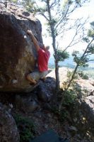
|
Ken Ariza on his classic testpiece Photo: Chris Summit
|
| | | | | | | | | | | |