Royal Arches, Royal Arches Area 5.10b or 5.7 A0 |
||
Yosemite Valley, California USA | ||
|
Google Maps Overview
|
|
|
The GPS coordinates for this route are shown below. See the GPS Marker Legend at right for details on each marker. Click on the Marker to see the actual GPS coordinates. Approach
From the northeast corner of the Ahwahnee parking lot, take the hikers trail east. After 120 yards and 50 feet after a stream crossing (may be dry in summer and fall), locate a climbers trail on the left. Follow this for 150 feet to a large left-facing corner and the start of the route. For Arête Butler and the alternate Royal Arches starts, skirt the base to the east (right).Descent: 3 Options
1) Royal Arches Rappel RouteThis is the recommended descent (see Royal Arches Rappel Route topo). It requires two 50m ropes or one 60m rope and starts from Pitch 15 of the Royal Arches route. This descent takes 2-3 hours. 2) North Dome Trail to Yosemite Falls Trail This 8.5 mile descent takes 4-6 hours, requires strenuous cross-country hiking, but has little exposure and no rappels. From the top of Royal Arches, walk north for about 1 mile (no clear trail) and pick up the North Dome trail. Walk west for about 4 miles to the Yosemite Falls Trail. Walk 3.6 miles down to Camp 4. 3) North Dome Gully If you have North Dome Gully wired, its the fastest descent from Royal Arches. It takes about 2 hours if youre familiar with the descent, but can take 4 hours if its your first time and you get off route. See the North Dome Gully Descent description for more information. If not familiar with North Dome Gully, then use the Royal Arches Rappel Route. |
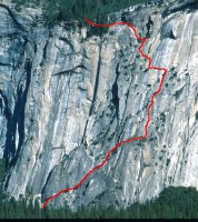 Photo: Chris McNamara
|
Home | Climbing Areas | Free
Topos | Guidebooks | Route
Beta | Forum | Trip Reports |
Photos | Articles
Links | Terms | Privacy | FAQ | Contact
| About Us
Climbing Areas
Rock Climbing Yosemite |
Big Wall Rock Climbing Yosemite |
Rock Climbing Tuolumne |
Rock Climbing Sierra
Rock Climbing Red Rocks |
Rock Climbing Southwest |
Rock Climbing Zion |
Rock Climbing Tahoe |
Climbing Alaska
All trademarks property of their respective owners
How can we improve SuperTopo? Got feedback?
![]() Let us know!
Let us know!
Climbing is dangerous. Climb at your own risk.