Triassic Sands, Whiskey Peak 5.10c |
||
Red Rocks, Nevada USA | ||
|
Google Maps Overview
|
|
|
A map of the general Red Rocks, Nevada USA area is shown below. No GPS coordinates for this specific route are available at this time. Approach
Accessed by an independent dirt road far from the gated Loop Road, Black Velvet Canyon is an easy and convenient area to approach. The obvious trail heads up from the parking area toward the mouth of the canyon. After a gentle climb, the trail splitsone branch dives down into the creek bed and the other climbs steeply up left to Frogland. The trail bypasses a small cliff band to the left, then contours right through brush to the base of Frogland, which is easy to spot by a 30-foot-tall white flake at the base of a big, brown left-facing corner. The Whiskey Peak crag routes begin 100 yards to the right. Descent
Descend all routes by rappelling. Follow the same trail back to the car.
|
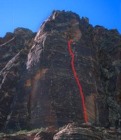 Photo: Greg Barnes
|
Home | Climbing Areas | Free
Topos | Guidebooks | Route
Beta | Forum | Trip Reports |
Photos | Articles
Links | Terms | Privacy | FAQ | Contact
| About Us
Climbing Areas
Rock Climbing Yosemite |
Big Wall Rock Climbing Yosemite |
Rock Climbing Tuolumne |
Rock Climbing Sierra
Rock Climbing Red Rocks |
Rock Climbing Southwest |
Rock Climbing Zion |
Rock Climbing Tahoe |
Climbing Alaska
All trademarks property of their respective owners
How can we improve SuperTopo? Got feedback?
![]() Let us know!
Let us know!
Climbing is dangerous. Climb at your own risk.