Olive Oil, Rose Tower 5.7 R |
||
Red Rocks, Nevada USA | ||
|
Google Maps Overview
|
|
|
A map of the general Red Rocks, Nevada USA area is shown below. No GPS coordinates for this specific route are available at this time. Approach
From Pine Creek trailhead, hike on the main trail down the hill and up the main trail up Pine Creek. Go past the Fire Ecology Trail (two entrances, it is a short loop), past an unnamed trail on the left, to the main Arnight/Knoll Trail (just past the prominent concrete foundation of the old homesteadabout 15-20 minutes from the car). Cross the creek, go right for 150 feet, then follow the nicely graded trail left and up the far bank. Hike on the trail for about 10 minutes, then take the right trail heading towards Cloud Tower. The first prominent trail on the right is the approach to Rose Tower and the Northeast Face of Jackrabbit Buttress (the descent trail from Rose Tower intersects earlier, but it is hard to see from the main trail). To continue on to Crimson Chrysalis, Geronimo, or anything up the main Juniper Canyon (Brownstone Wall, Rainbow Wall), stay on the left trail. Descent
From the top of Olive Oil (also the top of One-Armed Bandit), scramble up and left to the top of the formation, and hike back along the ridge top then down the gully. There is a 10-foot 4th class downclimb just before you reach the gullyuse care here, and the first down can spot partner(s). |
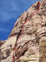 Photo: Greg Barnes
|
Home | Climbing Areas | Free
Topos | Guidebooks | Route
Beta | Forum | Trip Reports |
Photos | Articles
Links | Terms | Privacy | FAQ | Contact
| About Us
Climbing Areas
Rock Climbing Yosemite |
Big Wall Rock Climbing Yosemite |
Rock Climbing Tuolumne |
Rock Climbing Sierra
Rock Climbing Red Rocks |
Rock Climbing Southwest |
Rock Climbing Zion |
Rock Climbing Tahoe |
Climbing Alaska
All trademarks property of their respective owners
How can we improve SuperTopo? Got feedback?
![]() Let us know!
Let us know!
Climbing is dangerous. Climb at your own risk.