Cat in the Hat, Mescalito South 5.6 |
||
Red Rocks, Nevada USA | ||
|
Google Maps Overview
|
|
|
A map of the general Red Rocks, Nevada USA area is shown below. No GPS coordinates for this specific route are available at this time. Approach
The Pine Creek parking lot is most of the way around the loop road. Popular with both climbers and hikers, the rush is on as soon as the gate opens and the lot can fill early. The trail is large, well-worn, and easy to follow until almost at Mescalito, where one branch dives down left into the creek bed (almost always completely dry). To get to Cat in the Hat, follow the left branch of the creek past a series of steep dihedrals. Stay in the creek bottom or gain the benchboth options are good. After the dihedrals, head up the large gullyCat in the Hat starts on the right wall of the gully and is completely hidden until you are near it. The use trail to Cat in the Hat is major and easy to find, and there are no cliff bands to be avoided, so any of the several trails up to the base will work. Most people take about 30 minutes for the approach. Hopefully climbers and the BLM will get together and consolidate the many trails into a single marked trail to help reduce erosion at this highly popular spot. Descent
Rap the routes, and reverse the approach. Please do not travel in the wash, the main trail was built specifically to reduce traffic in this sensitive riparian habitat, one of the few in Red Rocks which nearly always has flowing water.
|
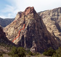 Photo: Greg Barnes
|
Home | Climbing Areas | Free
Topos | Guidebooks | Route
Beta | Forum | Trip Reports |
Photos | Articles
Links | Terms | Privacy | FAQ | Contact
| About Us
Climbing Areas
Rock Climbing Yosemite |
Big Wall Rock Climbing Yosemite |
Rock Climbing Tuolumne |
Rock Climbing Sierra
Rock Climbing Red Rocks |
Rock Climbing Southwest |
Rock Climbing Zion |
Rock Climbing Tahoe |
Climbing Alaska
All trademarks property of their respective owners
How can we improve SuperTopo? Got feedback?
![]() Let us know!
Let us know!
Climbing is dangerous. Climb at your own risk.