Tunnel Vision, Angel Food Wall 5.7 R |
||
Red Rocks, Nevada USA | ||
|
Google Maps Overview
|
|
|
A map of the general Red Rocks, Nevada USA area is shown below. No GPS coordinates for this specific route are available at this time. Approach
Hike down the old road from the White Rock Spring parking area (at the end of a short, but rough, gravel spur off the main Loop Road). Take the well-worn trail to the right when the road turns left and follow it up through a short bouldery streambed. Many trails lead up left to the base of the wall; please try to stay on the most heavily used (hopefully some trail consolidation work will be done here). The trails lead to the base of Tunnel Vision, which traverses under a large roof only 15 feet up to gain a low-angle dihedral. Group Therapy starts about 150 yards to the right of Tunnel Vision from boulders at the base of large trees, on the lower left wall of a huge shady chimney/recess. Descent
From the top of Tunnel Vision, drop down in the large 3rd class chimney and follow it left to a large terrace. Hike around into a gully, and either rappel 50 feet from slings around a large block, or hike up 20 feet and over into the next gully and descend there (3rd/4th class). Descend following cairns, past numerous short 3rd class drop-offs, boulder scrambling, and a lot of annoying oak trees and cacti. Swing around to the base to pick up gear. It will save you about 10-20 minutes if you dont leave gear at the base, but on the other hand the best trail back is to traverse all the way to the trail you hiked up on.To descend Group Therapy, go down the big 3rd class chimney, which joins the start of the Tunnel Vision descent after crawling under a huge chockstone. |
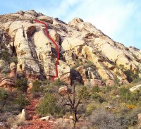 Photo: Greg Barnes
|
Home | Climbing Areas | Free
Topos | Guidebooks | Route
Beta | Forum | Trip Reports |
Photos | Articles
Links | Terms | Privacy | FAQ | Contact
| About Us
Climbing Areas
Rock Climbing Yosemite |
Big Wall Rock Climbing Yosemite |
Rock Climbing Tuolumne |
Rock Climbing Sierra
Rock Climbing Red Rocks |
Rock Climbing Southwest |
Rock Climbing Zion |
Rock Climbing Tahoe |
Climbing Alaska
All trademarks property of their respective owners
How can we improve SuperTopo? Got feedback?
![]() Let us know!
Let us know!
Climbing is dangerous. Climb at your own risk.