Chris McNamara
SuperTopo staff member

|
 |
Climbed this Sunday. No snow on route. Tiny bit on approach and descent. Its open for the season!
|
Rattlesnake Arch
Social climber
Home is where we park it
|
|
Note that the customary start of the Matthes Crest route (Traverse from South to North) is incorrectly plotted on the Supertopo map (eg High Sierra Climbing Second Ed, p 167). It should be approximately ½ mile North of the location shown, a substantial discrepancy. Use Peter Crofts map, which is correct, although he acknowledges "more rock to the south". Or, as you near the climb, ditch the map and just head for the patch of trees at the base.
|
Toreador
Trad climber
York, UK
|
|
Why in the world would you bail at the north tower?
If you were using the Supertopo guide perhaps, which describes the route this way.
|
gung-ho gun show
Mountain climber
Bend, OR
|
|
S-N Traverse on June 17th as part of the Tenaya/Matthes/Cathedral Linkup... First off I had two knobs pop on me while on the first two pitches. The down climbs are over rated and I would call them 5.5/5.6 if you were going up them, the 5.7 crux crack is more difficult. I down climbed off after finishing the North Summit and did not finish the ridge all the way. The position is awesome but the rock is variable and the movement is so-so a lot of the time. Maybe I just hit bad rock or got unlucky but it's not my favorite. Maybe I should have finished it out all the way and would have liked it way more (the down climb off was loose), but I took a look at the next tower, tried out the moves and didn't feel like it at the time. Also, if you plan to rap bring the tat. There is some up there but not much, a quarter-inch rusty bolt and piton form a passable anchor as you start the so-called 5.8 down climb but before anything committing.
http://mountainmischief.blogspot.com/2014/06/sierra-solo-pt-2-tenaya-matthes.html
|
Vitaliy M.
Mountain climber
San Francisco
|
|
Next time I will stash my extra food/water and emergency bivy kit at the rap station base.
Why would you do such a thing. Just do the whole thing and avoid the clusterfk of stashing gear etc. If you feel the need to stash something you must be carrying too much. As Mucci said, the northern part is a lot better IMHO
|
mucci
Trad climber
The pitch of Bagalaar above you
|
|
Why in the world would you bail at the north tower? The best climbing leads up to it and beyond.
It is a walk off traverse.
|
Ed H
Trad climber
Santa Rosa, CA
|
|
Wow - what a great alpine experience! Took us 12 hours car to car - about 3 hours to the base, 3 hours out, and 6 hours on the rock. We were in no hurry and first time out there. Sadly we bailed with four other teams before the South Summit, but I'll be back to finish the job! Really awesome being on that ridge, and the climbing is pretty mellow. Next time I will stash my extra food/water and emergency bivy kit at the rap station base. I'll also bring webbing to bail (or help others bail), and I'll use locking biners to attach my descent shoes on my harness - we saw a guy drop his shoe over the East side - I can't imagine hiking out 3 hours with a pack in my climbing shoes! Ouch!
If you haven't seen this video, check it out:
http://vimeo.com/76365036
|
Jerry Dodrill
climber
@dodrillphoto
|
|
Climbed it yesterday. Summit register resembled a wad of sweaty photocopies after a SuperTopo Pity Party. If you are heading up soon, please take a little spiral notebook to leave behind.
|
Chris McNamara
SuperTopo staff member
|
|
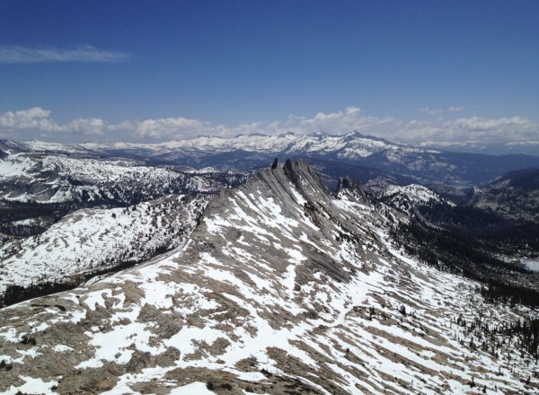
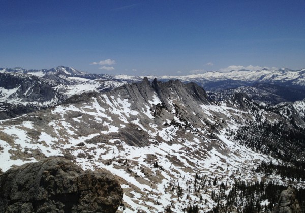
here are the route condition on May 18, 2012. Climbable, but a little snowy on the approach and if you want to rappel halfway through (which is the way most people climb the route). In a week i would think it would be ready to climb with minimal snow.
|
schaffner
Trad climber
|
|
It's getting crowded, we were the third party on the route at 10am last Friday, more people showed up later... probably 20 in total.
Nuts weren't that useful, singles in cams would be enough, maybe doubles in BD red.
|
rhyang
climber
SJC
|
|
Finally got up the north summit on Sunday, Sept. 5th after my first attempt in 2009. We belayed the first two pitches to the crest, then soloed to the notch between the two summits.
I led the 5.7 left-leaning finger crack with knobs above and found it pretty strenuous. My partner could not follow it, but he hadn't climbed anything technical for nearly a year. Another party went further left to a ramp-type thing and popped out a bit north of the north summit.
We (myself and the other party) rapped off the north summit using both 60m ropes using the rap station a bit south of the summit area -- not easy to see (as shown on the topo). This got us down to the notch, and another two-rope rap got us down all the way.
Fun route, have to come back sometime for northern part sometime.
|
TLloyd-Davies
Trad climber
Santa Clara, ca
|
|
Fantastic route, offers all kinds of goodies along the way.
Sure the whole thing isn't all technical climbing but the views, location, length, and over-all spectacularness (did I make up a word?) make this classic.
Early on stay right and towards the top of the ridge (if going south->north). It's pretty obvious but I was rudely introduced to insecure exposed soloing after getting off-route. Oops.
Other than that it was one of the most fantradstic climbs I've done in a while. I highly recommend finishing out the whole crest, don't rap after the North summit. There's one 5.7ish step across and everything after is well below that rating.
|
Chris McNamara
SuperTopo staff member
|
|
A cool backpacking trip report here
http://www.supertopo.com/climbing/thread.html?topic_id=963802
|
Paul
Trad climber
Muir Beach, CA
|
|
This "climb" is basically described as a stroll along a sketchy sidewalk. It is extremely overrated and can be very crowded. The best part (and the only reason it gets 2 stars) is the views and hiking the pass by Echo Peaks to Budd Lake. BTW, there is much better climbs on Echo Peak.
I've been climbing for 30 years and wish I would have waited another 30 to even think about doing this "climb."
|
sharon
Trad climber
Bay Area, CA
|
|
Despite a fair amount of snow still on the trail, it was no problem hiking to the climb. The mosquitoes were in full force. Once we got within view of the usual descent, we noticed that there's still a pretty major snowfield at the base of the rap route. I'll try to upload a photo. We bailed since we weren't equipped for any kind of steep, though likely semi-soft, snowpack.
|
Chris McNamara
SuperTopo staff member
|
|
great trip report here
http://www.supertopo.com/climbing/thread.html?topic_id=821345
|
Toreador
Trad climber
York, UK
|
|
Would be good if the guide could give more information on the continuation from the north summit. 'More difficult and harder to protect' (or something like that) didn't give enough for us to decide whether we could do it or not so we did the 'normal' rap descent.
Which we'd probably have done anyway if as 'caughtinside' says the continuation involves several 5.8 moves, as 5.7 is currently about our limit - the short crack on the last pitch was more than enough! (Incidentally, we thought the short wall at the start of that pitch described in the guide as 5.7 was more like 5.4 or 5.5).
On the approach, we left the climbers trail too early so missed the good trail to Budd lake on the way up. Obviously not the first to do that, we followed vague deer trails and passed the occcasional boot print and cmall cairn. I don't think it added significantly to the approach time.
|
That Darn French Guy
Trad climber
Santa Clara, CA
|
|
Suprtopo confused me a couple of spots, on section where there was actually a topo for it.
Part #2 hows a small spire saying "5.2 block" and 2 vertical cracks. Well an arrow would be nice, because in the action I misread the topo and tested out those 2 cracks. The left one I tried to aid out of it, and my #.2 camalot eventually popped out... Hard top-out. So I downclimbed and did the right one, and it's more like manky 5.9 than 5.2... Works though.
Part #5? going around south summit to the rap rings: The topo again would benefit with an arrow pointing straight across from the pine tree. I tried to go all the way down the ledges, which lead to a vertical wide crack I almost commited to. Argh! Way off route would've been a misery to recover from that.
One can't afford to loose so much time route finding.
Also the trail to use forks left from the Cathedral Peak trail like 10mn after a spot on the trail where you have to go over a 5ft boulder. If you go straight down instead you'll find a trial that crosses the river then fades away and you have to go X-country all the way to the crest from there.
|
Fletcher
Boulder climber
Institute of Better Bouldering-DirtbagDad Division
|
|
I did this back in August 2007 with 10b4me. Well, it goes to show you how we all have different perspectives. :-) I found it to be a blast... like climbing on a summit all day. We had to skip the North Tower because we were with a slower second party. I'd do it again in a heart beat!
|
madturtle
Trad climber
folsom, ca
|
|
Did this route as a link up w/ Tenaya peak on Saturday. Would have liked to bag cathedral peak too but my 10 a.m. start and another SNAFU didn't really allow that. In any case contrary to the link up beta below from the S end of Matthes (I had to go get my shoes that I accidentally left at the base of the climb) I hiked over to cathedral pass around the N side of Cathedral Lakes down the spillway and followed the creek that drains from Cathedral Lakes to the E end of Tenaya Lake where I was parked. Beautiful x-country hike with minimal real bush whacking. However early season might be a little wet especially at the end, but probably not too bad.
I also noticed that I had beat 2 other party's that were only a little behind me on the climb when I passed the John Muir trail head FWIW.
|
10b4me
Social climber
Lida Junction
|
|
just did this yesterday. owing to time constraints, we rapped from the south/north col. this climb(imo)is fun in spots, but somewhat repetitive.
|
LosGatosAl
climber
Los Gatos, CA
|
|
Don't rap off; good stuff further north. Nice solo with lengthy approach/decent. Bring a beer or two.
|
Chris McNamara
SuperTopo staff member
|
|
cool trip report here
http://tradmobility.fastercat.com/
|
caughtinside
Social climber
Oakland, CA
|
|
I'm not sure why rapping at the North summit is recommended. It's much better to finish the traverse, and that only adds 4 or 5 5.8 moves.
|
malabarista
Trad climber
Portland, OR
|
|
Climbed this yesterday and on the approach there was a dusting of snow on the ground -very cold outside. The snow all melted by noon and the weather was perfect for climbing... but we did not see anyone the entire day either on the crest or hiking back by Cathedral peak.
We started at about 7 am and were back by 6pm... this with getting off track a few times on the approach by Echo peaks, taking our time on the route and on the hike in and rapping from North Summit.
Very nice climb, spectacular views, the technical climbing as far as the North Summit is trivial. Great fun -especially if you are "climbing off the couch" as I've been doing lately.
I'd put this route in a general
category of "hiking crux" climbs with Snake Dike.
|
Vic Klotz
Trad climber
San Diego, CA
|
|
We did this as a party of three on Sept 15th, 2005, but due to time constraints, opted to skip the North Tower. It should be noted that you can easily 3rd down to the 'tree' rappel anchors between the North and South towers from the 'notch' in between.
This is a really fun, moderately easy climb. If you're really confident in your abilities, you might consider climbing the route in five-tennies! Of course, I'm only speaking for the part of the route we were able to complete, it was that easy. We took our time (about 8 hours) and really enjoyed the climb, pausing to take lots of pictures and make hard moves out of easy ones!
We also had the entire route (as well as the surrounding basin) to ourselves.
Have fun! We did.
|
Sid
climber
Bay area
|
|
Hello. I was on Matthes crest on Sep 22,2005. I lost my camera on the way. Its an Olympus Camedia 760 in a black case. I might have lost it on the trail. If you do find it please let me know.
|
Duke-
Trad climber
SF, aka: Dirkastan
|
|
My buddy denis and i were there last wednesday aug 24, every thing was wonderful. He lead to the right up a golden slope of knobs, with wonderful gear every 15 feet. We simuled the whole thing. I was surprised to find out that so much walking was involved. We brought only one rope, hoping that an intermediate belay was available. It was. There is really no reason for a second rope. (we also did echo peak 3, the cox comb, and the unicorn? in one sesh. Sure we drank from streams, fought pounding headaches, and ate snow. But hey the 16 hours of marching and climbing was worth the glory. We missed the cathdrel though)
|
Stefano
Mountain climber
St. Paul, Minnesota
|
|
Was on Matthes Crest(south to north, rapped off the north summit)on July 3. Lots of snow on the approach still, but managed in approach shoes. Early morning, look out for ice on the approach slabs. Belayed the first three pitches, and the one pitch up the north summit, but simul-climbed everything else. We left the trailhead around 6:30 a.m., and were back at the car by around 8 p.m. We moved as quickly as possible, but the sun-cupped snow below the col definitely slowed us down.
Want a brand-new Olympus Stylus? I dropped mine down-climbing to the gap between the north and south summits. It was in the case, so there's a chance it's intact. It's on the east side of the gap. I'm sure you could rap down the gap until you find it. It's very ledgy, so how far could it have fallen? Probably not a difficult climb back up. It was already too late in the day, and I was too whipped. If you find it, keep it, but send me the memory card (Steve Davis, Box 333, Lander WY, 82520) and I'd be very grateful.
|
whatsupdoc
Trad climber
South Lake Tahoe, CA
|
|
We did this one June 26 (we rapped, not the entire ridge) and there was a ton of snow on the approach. It really slowed us down. Definitely recommend boots & gaiters, plus trekking poles and/or a light axe. In fact, the snow sections getting up to the beginning and getting down from the route were the scariest part of the day, as we brought no crampons or axes. It would be really tough to do the approach in the recommended time right now with the conditions the way they are, unless of course you're soloing and not carrying much gear. It took us about 3:45 from the trailhead.
Great rock and very cool exposure once you're up there. Have fun.
|
Chris McNamara
SuperTopo staff member
|
|
i just got this beta from a supertopo user
That 5.4 is f'ing scarry. I followed your advise of not clipping the lowest piton, which turned out to be a mistake. I actually ended up with more rope drag clipping the higher one. Don't ask me why. The next party up clipped the lowest one only, and had no problem.
|
clarQue
Trad climber
Mill Valley, CA
|
|
Here's a quick snapshot of the Tenaya/Matthes link up David mentions below.
[Click to View Linked Image]
You can get more details of this route online at MotionBased.
|
davidji
Social climber
CA
|
|
There's a shuttle from the cat lakes/JMT trailhead where you'll finish, to Tenaya Lake where you'll start, running on the half hour, at least some of the time. So no long highway hike required for the Tenaya Peak approach.
|
David
Trad climber
San Rafael, CA
|
|
Tried Matt's recommendation yesterday and used Tenaya Peak as a warmup/aprroach climb before blasting cross country to Matthes Crest. From the top of Tenaya it is indeed a mostly downhill cruiser hike to Matthes Crest with killer views. Ofcoarse, if you want to hike back to your car at Tenaya lake this means that you have a rather long hike back after finishing Matthes. We ended up hiked back via a long route that skirted Mildred Lake and dumped us out at the West end of Tenaya Lake. I think our GPS clocked it at 13 miles car to car.
|
Matt
climber
San Rafael, CA
|
|
if you are comfortable soloing 5.2 and at all fit, then cruising up tenaya peak is also a nice approach (and a good warm up!).
from the summit it's nearly all flat and downhill if you take a B-line to the S end of MC.
finish w/ a sunset viewing on top of CP- ahhh, heaven don't suck!
(some jerk once told me that the above path is a contrived link-up, but he don't know JACK!)
|
davidji
Social climber
CA
|
|
Beth,
The JMT for the approach is quite long. You can take the Budd Lake trail, but not go to an Echo Peaks saddle; instead you can skirt around Echo Peaks on the right. I would only climb to the Echo Peaks ridge if I were doing the traverse from North to South. Haven't tried it that way though. Maybe next time.
|
moabbeth
Trad climber
Los Angeles/Moab
|
|
As for the approach, if you're someone that lives at sea level and comes up on weekends like me, do the Cathedral Lakes trail approach. While it's technically longer, it's flatter, shadier, and *most important* the altitude gain is more gradual and much less pronounced. We took the CL trail on the way back, but we took Budd Lake to the saddle of Echo Peak as the approach. Mileage wise it's faster but the altitude gain is way more intense, there's almost no shade and there's some jingus scree up and down the saddle. But if you're acclimated and fit, the Echo Peak way is technically quicker.
|
dufas
Trad climber
CA/NV
|
|
This is a very fun route. Efficient simul-ing and un-roping and you can finish this very quickly, but why bother? It's too much fun being up there. Kind of like the last moves to a great summit over and over again. If you want protection, you should bring extra gear from 1-3" like the topo says. Not much small gear to be had and nuts/hexes don't work that well on the traverse parts.
I was a bit confused by the approach information as well like the prior poster, but if you cross the creek at about the point indicated and just head up between the two creeks, you can't miss Budd Lake and its easy walking. Then just head off to the right of the stuff in front of you and you're there.
I gave four stars because of the spectacular location. But the amount of technical climbing from the south edge up to the North Summit is really minimal and not terribly interesting. It sounds better if you go all the way to the north, which we did not.
Popular route. There were three parties ahead of us and three behind us, but the nature of the route made it so this was not annoying.
|
Mei
Trad climber
mxi2000.net
|
|
The route is awesome. Did it on July 4th with Spiderman. Wild!
We found the approach beta on the topo confusing (my partner is a native english speaker, so it's not a language issue). "Follow ths trail for about 1.5 miles to a creek crossing where a small trail heads up on the right bank of the creek. This is the Cathedral Peak climbers' trail. Instead of taking it, cross the logs and head up the main trail on the west side toward Budd Lake." Once you cross the creek (on the logs), you end up on the east side of the creek, right? We also found two trails on the west side of the creek, on stays very close to the creek, and one heads up to the right (Cathedral Peak climbers' trail).
I assume all three trails would eventually lead to Matthes Crest if you get the landmarks right. So don't panic if you seem to have lost the trail. We took Cathedral Peak climbers' trail on our way in because the ground was covered under ice from the hailstorm the day before and we wanted to stay away form the creek, but we took the trail right next to the creek (on the west side) on our way out. Both were good. Didn't feel much difference in distance. Does anyone recommend that trail on the east side (after crossing the creek)?
|
Sir Run-it-out
Trad climber
mxi2000.net
|
|
The approach is much easier, and faster, if you don't hike up the talus slopes to the notch between the Echo peaks, but instead go through Cathedral Pass, ie to the west of the Echo peaks. No scree, very little altitude gained/lost, and as of 6/19/04, dry.
Found many, many slings on the route. Cleaned a bunch of the rotten ones, and passed on some good sewn runners, 'biners and other booty gear to other parties on the route, as I was out for a long day of soloing and was too lazy to carry more gear.
|
August West
Trad climber
Where the wind blows strange
|
|
My partner and I also just did this route. I thought the second half of the traverse, from the North summit on was much better than the first half. It is more technical and even more exposed. In several places the crest tapers down to a few inches at the top and you do long hand traverses with your hands gripping the "knife edge" ridge. Wild. The ridge climbs all the way out, you can finish up on third class, no rapping needed and nothing harder than hard 5.8, pretty amazing.
For the second half, the first climber should be a solid 5.8 or 5.9 leader. Good route finding skills will help you pick out the path of least resistance. The second climber should be prepared for some sections of 5.8X climbing.
We got by with double cams from fingers up to small hands (#1 camalot), simul-climbing and running the rope behind natural features for most of our protection (note: I wasn't trying to sew the route up). The only place my rack seemed skimpy is near the end (second to last summit) where a large hand piece (#3 camalot?) would have provided a much better anchor if my second had whipped off a 5.8X corner/downclimb.
We also cut up early on the approach and had no problem. We had to meander around some and scramble across a couple of wet sections that may have been icy earlier in the season/morning. Staying low may well be faster.
For the approach, we started out on the Cathedral Peak trail and then kept going straight (south) when the Cathedral Peak trail headed sharply up and right (west)--at this point we were 10~15 minutes or so from the start of SE Cathedral. The saddle immediately below (south of) Cathedral is not the one you want. Take the next one to the left (just right of an obvious ridge/fin). If you stay a bit right, you don't have to gain and lose as much elevation. Approach took 3 hours. Simul-climbing (one step removed from free soloing) in two long blocks took 4 hours. (I also stopped a couple of times to give my second a closer belay on tricky downclimb sections or delicate traverses where I didn't want to yank him off.) Descent and hike out took 2 hours.
|
Colt45
Trad climber
Seattle, WA
|
|
We climbed the full ridge on 6/15/04. The approach had mimimal snow, but we got ourselves into some trouble at the end of the approach where you scramble up to the south end of the ridge--we cut up too early and had to traverse some steep, icy, sketchy snow without appropriate gear. Traverse under the ridge low before cutting up and it should be mellow talus-hopping. The remaining snow should be gone soon.
The down-climbing from the north summit onwards can be protected reasonably well if the leader is really careful, but the second should be solid down-climbing with occasional fall potential.
We simul-climbed the whole ridge (no rappels needed) in about 7 hours, which seemed like a pretty long time because we were moving continuously! It started to rain for the last ~500 horizontal feet of climbing before we hit the ground, which was ample incentive to up the pace.
Bring lots of medium to hand-size cams and long slings; small cams and nuts were not very useful. You can also flip the rope over features for pro.
We hiked out the way we approached; afterwards we saw that the Croft guidebook says to descend by walking north and passing echo peaks on the right side. Since this would eliminate the need to hike down then back up to echo pass, it is worth considering.
I gave it 4/5 stars because the position you are in is really amazing and the ridge is a beautiful feature, but there is not much technical climbing involved.
|
Chris McNamara
SuperTopo staff member
|
|
The American Safe Climbing Assn. may have replaced anchor bolts on this climb. To find out visit the ASCA Replacement Page
The ASCA is a non-profit organization dedicated to replacing unsafe anchors. To learn about helping the ASCA click here
DONATE NOW
|
esq
Trad climber
san francisco, ca
|
|
We approached the south end of the crest by hiking past Cathedral Lakes, on the right of the trail. Beyond you keep hiking on the trail until the unmistakable crest comes into view. Trend left across the beautiful meadow towards the south end of the crest. We must have left the car by 430AM, arriving at the rope-up point by 730AM. On the way back home we did the West Pillar of Eichorn Pinnacle, arriving back at the trailhead/car by 8PM. (Using a topo map, we avoided the Wilts Col altogether by trending around the plateau to the west of Echo Peaks.)
The Crest would be an awesome solo with big exposure on either side of the "dragon's back." See the downclimbing beta in an above posting for getting off! Someone has posted a suggestion for combining Tenaya Peak, the Crest, and Cathedral in a day. I'd like to get a car-to-car time estimate on that link-up! I think you'd almost have to assume free soloing the whole time, or occasional rope-ups with a light rope.
|
PATAGANJA
Novice climber
san francisco, ca
|
|
Great fun!!
Peter Croft just upped the the "Roman Numeral" grade to IV.
I think he is right. We had a LONG day Car to car. It was rated the same as Cathedral. I did that car to car in a morning, big ass difference.
Try it you'll love it.
Later in the summer bring a lot of water.
|
OldAndSlow
Trad climber
Los Angeles
|
|
Fabulous climb with spectacular positions. Climbing is very easy except for pitch to N. summit---much of it like a sidewalk in the sky. Two old (50 and 55), slow climbers took 8 hours from rope-up to off-rappel.
The party behind us rappelled from the N. summit with one rope, and a little easy 3rd class climbing.
|
joan marshall
Intermediate climber
Los Angeles
|
|
My Dream Climb...
Backpacked in on Friday, August 16, to Mathes Lake. Camped at north end, climb finish. Last water at Budd
Lake, until close to Matthes Crest.. Headed left toward Cockscomb to the saddle. Snowfield provided more water at the Saddle.
Climb on Sunday, August 18. Started 7:30 am. Shady and Cool. Hot by 9 am. Didn't see anyone on the route until late in the day.
Carried one qt water, and three top layers. Only one was really needed. Hot!! Some wind by afternoon.
Made the summit block by noon. Register box was there, but no paper or pen.
Pitch below the summit block was hardest. 5.7 at least. Maybe 5.8. I climbed it using a chimney technique. Quite a grunt.
We got to the second gendarme from the north end, and rapped off. 8 hours of climbing.
Backpacked out, starting at 6:30 pm. Took a direct route down the canyon below Unicorn. Had
to work around a hardened snowfield, between two high cliffs. Narrow walkway. But, it went. Worked our way
down 400 ft of low angle slabs. By now, it's getting dark. Picked our way continuing left and down, towards
Budd Creek. Did two stream crossings, and finally reached the Budd Creek trail. Three hour hike out, all
together.
Did the climb with Hal Tompkins. He led most of the pitches. We belayed most pitches after reaching the summit
block. A lot of downclimbing. Weighted a knob with my foot, and the hold broke. Fell about four feet, while
downclimbing. Could have been a long fall, but the descent was protected by swinging the rope over
a bulge above.
Awesome!! Some parts of the rock look like giant waves. You hold on to the edge ot the wave, and traverse
across, balancing delicately on small granite knobs for quite a way.
Joan Marshall
|
| | | | | | | | | | | | | | | | | | | | | | | | | | | | | | | | | | | | | | | | | | | | | | | | |