sierraman
climber
CA
|
 |
Anyone have any info on current conditions ?
|
splitclimber
climber
Sonoma County
|
|
Thanks Steve. We did this descent and it worked out well. Descend the normal way to Sawmill to the end of the flat meadow area before the last long drop to Lee Vining Creek, then contour left around and up a little bit on clean granite slabs staying above a cliff band. You'll wrap around then down a bit and over to the greenstone saddle, then down an OK use trail that is not as loose as the approach to N. ridge.
It's a great loop!
Mosquitos are bad, but I heard not as bad as the weekend before.
|
Stevee B
Trad climber
Oakland, CA
|
|
This route has been working well for me. You may also be able to drop down the couloir directly South of Conness Lake.
http://ridewithgps.com/trips/3381491
|
10b4me
Social climber
Lida Junction
|
|
Been years since I've done the North ridge, and I don't remember any bolted anchors. That means you would have to leave gear, or just downclimb. Descending off of the west side of the North ridge is problematic. I had a friend do that, and he said it was epic. Plus, I am not sure you can get to the Conness-North Peak saddle from the west.
My suggestion would be to take the east ridge descent as far as possible. just my.02
|
splitclimber
climber
Sonoma County
|
|
If overnighting in the conness/north peak basin out from saddlebag, what is the best descent off of Conness to get back into the Conness Lakes drainage. I've seen footprints before dropping north off the flat lower ridge, east and below the Y couloir/plateau but don't know if there is a better way, esp. without crampons/axe.
What about going back down N. ridge or off to the west a bit from N. ridge?
|
aran
Trad climber
berkeley, ca
|
|
Had a great day out linking this with Northeast Ridge of N Peak. I highly recommend the link up- beautiful aesthetic line and rock quality, doesn't add much time. We did the whole day in 10 hours, with an accidental LONG approach mistake and very casual climbing pace. The descent also took us about 3 hours, going easy and finding our way. On the approach in, definitely go left at the boulder on the far side of Saddlebag Lake and then follow the trail around the lake to the right at the base of N Peak, then up to the ridge. Took us just under 2 hours at a decent pace, but we went way out of the way. then 45 minutes to the top of N Peak. No rope/ pro needed anywhere for this one. Only a short rope for the rappels on N Conness if you don't want to down climb, our light rack and 60 meter rope proved a burden to just haul around all day un-used (good training, eh?). At no point did we feel the need to rope up on the climb, and we are by no means daredevils. Just pick your line and go easy- really really fun. I'd definitely do this again- such a beautiful day out- but with only approach shoes and a 30 meter rap line, if at all.
|
schaffner
Trad climber
|
|
We did the same wet 4th/5th class descent. We met some other people there who said that this is where the descent is. Apparently it's a lot easier and more obvious when dry.
|
squishy
Mountain climber
|
|
No mention of the bridge? It was the crux of my descent.
|
gonzo chemist
climber
the east coast, for now.
|
|
Awesome descent beta (with pictures) can be found here: http://dreaminvertical.wordpress.com/2009/09/21/mount-conness-approach-beta/
|
twicken2
Mountain climber
San Diego, CA
|
|
I cliffed out during the descent on the northwest side of the small peak north of alpine lake and had to downclimb some wet 4/5th class. I was told afterward that the correct descent goes south of this peak.
The topo in the book definitely shows skirting the peak to the north, anyone know if the south side actually stays 2nd/3rd class?
|
squishy
Mountain climber
|
|
lol...sorry for the third rap anchor between the older two, seems I screwed some people up. I couldn't find the second when we did the route a month ago, we left an anchor in the place described below. If anyone is heading out there, please remove the intermediate and unneeded third rap anchor, it just lends to confusion...
|
le_bruce
climber
Oakland, CA
|
|
Disagree with you, chrisferro. My experience after 3x on route:
-No rap really required, more like optional short rap or 5.6 downclimb. I've done the down climb each time I've been on route and it is right in character with the rest of the climb, not much harder.
-If rapping, only one short rap, then traverse climber's right on 5.easy to gain excellent cracks.
-Climb to top, staying as close to the true ridge as feels good. Generally, best climbing, views, exposure are on the knife edge.
-No rap required at top if staying on/near ridge and using easy route-finding.
|
schaffner
Trad climber
|
|
Climbed it on August 13th. Still some snow on the approach, took us 3 hours. Climbing was pretty straightforward, 3 hours of scrambling and simulclimbing. Descent (4.5 hrs) was the bad part: first traveling through suncups, then a treacherous descent just northeast of Alpine Lake, heinous mosquitoes, muddy trail and finally the interesting stream crossing also mentioned by chrisferro.
GPS:
Approach) I think we were at the split in the trail at the distinct boulder before the coordinate give in supertopo.
Descent) We dropped of the plateau at N 37°57.938' / W 119°18.824', passed a carin at 37°58.034' / W 119°18.510' and found a trail leading to Sawmill at N 37°57.727' / W 119°17.654'
|
chrisferro
Mountain climber
Virginia
|
|
We did this August 11, 2011
The approach is very straightforward, though there was quite a bit of snow still around.
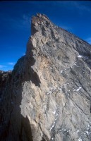
We stayed on the east side of the first tower - easy scrambling with a lot of exposure.
At the top of the second tower, we did 3 rappels. The first was about 75 feet straight down the corner. Then we scrambled up and right to the next rappel anchor, and did a shorter rap down and slightly right. Then we scrambled just 15 or 20 feet up to the 3rd rap anchor and rapped about 60 feet straight down that corner. I've heard that there are only 2 raps, but there are actually 3. After that, it's all easy with the occasional 5th class move. We simulclimbed the whole thing. Stay away from the true ridge or you'll top out on a few little towers and have to go back and around (or do a quick rap off of a nut, like us to save time). Fun route. The descent is also straight forward, but long! The crux is crossing the log over the raging creek (in the dark) just before the campground.
|
Johnclimbrok
climber
CA
|
|
Stay on the WEST side of the 1st tower if you want 3rd class ledges. The East side "3rd class ledges" is more like 4th / 5th with tons of loose rock. This should be updated in the next book. Peter Croft's guide got this beta right.
|
Chris McNamara
SuperTopo staff member

|
|
here is a great trip report
http://www.supertopo.com/climbing/thread.html?topic_id=913390
|
mikeyb
Trad climber
San Francisco, CA
|
|
Anyone have info on conditions? I'm guessing the route is clear of snow, but I'm curious if the road is open and if the approach is clear (or if it's just one big mud bog). I'll hopefully be heading up there either this weekend or next. Thanks.
|
caughtinside
Social climber
Oakland, CA
|
|
Really fun day. We simuled the route, pretty straightforward. 9.5 hours c2c, which includes time to stop and enjoy the veiw...
recommended!
|
Mike Dahlquist
Trad climber
Oakland, CA
|
|
That is one SICK LINK UP!
|
Mr. Byrne
climber
LA, California
|
|
This is a fun link up - North Peak ice gully to North Peak summit then North Ridge of Conness. We did it in a long day from sadle bag lake early summer. Dont skimp on the number of screws. They place faster in the gully than rock gear (I think we took 7). We simul-soloed the Conness ridge in mountain boots. There was a fixed line for raping a step 1/3 the way up the ridge. Looking back, I'd take a single half rope, 8 nuts, 6 sm-med cams, and long slings. If you don't like the crest, move right and it's all 4th class.
|
benpullin
Boulder climber
SLC, UT
|
|
I soloed this route on 8/25/06, CTC. The Supertopo beta for the approach was perfect, and the route was lots of fun. I think I got a little off-route into some sandier/dirtier rock, but it was easy to climb back into better territory.
I'd say the entire route was 3rd to 4th class except for the 5.6 downclimb. A note on that: do not downclimb the big corner immediately below the stance beneath the first rappel point. Traverse farther toward the summit and you'll see the correct corner, which is closer to vertical.
The descent seemed long but I'm glad I've done it so that I can go back and do the West Ridge. Going up the West Ridge and down the North Ridge would be a stellar day...
|
davidji
Social climber
CA
|
|
If you park by Saddlebag Lake Dam, what's the best hike back there from the summit of conness?
I hiked down past the Carnegie Institute shed, bearing left on the trails after, till I got a waterway that I assummed (correctly) was the spillway from Saddlebag Lake, then hiked a faint, sometimes disappearing trail up & north to the dam.
From the topos it looks like I could have stayed on the ridge, south of the conness glacier, contouring around a small peak E of Conness and drop down right at the dam. My most detailed topo map has 50' between contour lines, and there could be plenty of difficult terrain I'm missing.
Anybody here downclimb the North Ridge?
|
The Jackal
Trad climber
South Lake Tahoe, CA
|
|
Did the route last week. We linked up the north ridge of North Peak (4th class with some easy 5th mixed in here and there) to the North Ridge of Conness. Made for a sick day. Brought a rope for the rappels and soloed the rest. Left at 6:00 am made the summit of North Peak by 9:00 and the summit of Conness by noon. The only beta I've got is that there is still a bunch of snow on the descent which can be steep and slippery at times. So if your not comfortable with that I would suggest some sort of boot crampons or ice axe but it's not that bad if you go slow and pay attention.
|
clarQue
climber
Mill Valley, CA
|
|
Check out the North Ridge of Mt. Conness route tracked with a GPS device at MotionBased - http://trail.motionbased.com/trail/episode/view.mb?episodePk.pkValue=1149760
with an accompanying photo trip report -
http://www.flickr.com/photos/clarque/sets/72157594218631840/
|
Chris McNamara
SuperTopo staff member
|
|
just got this note from a yosemite ranger:
I was climbing conness the other day and noticed that you recomend in your book to camp at alpine lake on the east side of conness. I wanted to tell you that alpine lake is within the hall research natural area. It has been a vegetative research area for over 30 years and camping has been prohibited there for a long time.
|
Mike Dahlquist
Trad climber
Oakland, CA
|
|
For a sick link-up, do one of the couloirs on North Peak before the North Ridge on Conness.
|
Crodog
Social climber
|
|
Left Saddlebag dam at 7:00 am and roped up around 11:00 am. Completed the double rappel around 3 pm. Reached the summit at 7:00 pm. Bivied at 10:00 pm about half way down (11,400') on saddle (before steep descent through chutes) after headlamp gave out. Snow during the night. Reached Sawmill campground at 9:00 am. Mono County SAR reported similar events every couple of weeks this summer.
|
DRiggs
climber
Truckee, CA
|
|
Soloed N Ridge on 07/03/05 as link-up following NW Ridge of North Peak. Saddlebag Lake road is not open, so started approach from Tioga Pass Road (120). Approach was relatively slow due to highly suncupped snow from just across the dam virtually all the way to base of NW Ridge on N Peak. One steeper snow slope to cross on descent of N Peak to reach col between it and Conness. There was a fixed rope left on the 2d rappel off the 2d tower of the N Ridge. It's been several years since I previously climbed the route so maybe it's been there a while, but I hadn't heard of it. The rope seemed in decent shape but was jammed on tension into flakes below and therefore not usable for me (I freed the jams as I passed them on my way down). Not to start some huge ethical debate, but I respectfully offer that this fixed rope is trash or at least inappropriately left in this location. If I'd had any room in my pack (I had brought my own rope for the rappels), I would have removed the fixed rope and carried it out. Perhaps someone on the route with a partner could do so. It was presumably placed there so soloists could rap instead of downclimbing the 5.6 corner. I think that if you want to solo, don't want to downclimb, and don't want to carry your own rope, you're asking too much. You should find a different route for that experience instead of affecting the experience of others on this High Sierra classic.
|
Fat Dad
Trad climber
Los Angeles, CA
|
|
You're right, this climb does make for a long day. I and the buddy I did this with both mt. bike and road ride alot and, while going up felt fine, admittedly, by the time we finally got back to the car at Saddlebag, our legs felt pretty worked. That's a pretty typical day in the mountains though.
I think the rope can stay in the pack no problem until you reach the rappel/5.6 downclimb. From there, we simul climbed two long "pitches" to the summit, keeping pace with a pair of guys soloing in front of us. The only other tip I'd recommend: we were jonesing to get to the ridge crest too quickly and veered far left on the approach, and ended up having to rope up for two weird pitches to reach the north ridge proper rather than backtracking. If you just follow the path of least resistance up to the low point on the ridge, you're much better off. This will seem obvious on the approach.
Overall, though, a great route with great position, great views and nothing too gnarly for those looking to hone their mountain chops.
|
CRDUERIG
Trad climber
Castro Valley, CA
|
|
Climbed with my friend on 7/25/04 in perfect weather.
We are not a fast team so we started early at 4:00AM from Saddlebag Lake. It took us about 3 hrs to gain the obvious ridge and we roped up in another 30 minutes (probably too early). Simul-climbed and easy belayed pitches got us to the summit at 1:00PM. After about an hour resting on the summit, we hiked down via the SuperTopo descent route to Sawmill campground in another 4.5 hours (slow).
Route seemed to be comparable to West Ridge of Conness, or Matthes Crest, or Cathedral Peak. Long day and tough workout, not to be taken lightly.
|
Polly
climber
|
|
Climbed this on 06/27/04 - it's a great climb with a beautiful approach.
Most of the snow had already melted off of the approach, and the snow patches that remain are easily avoided. There is a lot of snow on the descent (where the descent joins the West Ridge approach/descent), but it was already very soft by 11:00 am and easy to get down.
|
Chris McNamara
SuperTopo staff member
|
|
This is a great link up. Mileage without too much technical stuff.
yep, start at Saddlebag. Climb up North Peak from the NE then down the opposite side to the North Ridge of Conness. However, don't walk to lembert or you will have to shuttle cars. better to do the descent/approach for the West Ridge of Conness. Once you hit the road then walk back up to Saddlebag Lake.
I should mention this in my next High Sierra or Tuolumne Book.
|
Clayman
Trad climber
CA, now Flagstaff
|
|
Any thoughts on soloing this route linked wiht north peak? Would a good idea be approching North Peak from Saddelbag Lake, climbing NP and the Conness via the north ridge and walking out toward Lembert Dome? Thanks for any ideas.
|
*What is "Route Beta"?
It's climber slang for information or tips on a route as in, "what's
the beta on that route?" As a service to fellow climbers we ask SuperTopo
guidebook users to post tips and updates to this website if they have relevant
information to share after a climb.
| | | | | | | | | | | | | | | | | | | | | | | | | | | | | | | | | | |