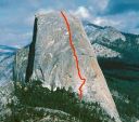
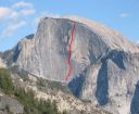
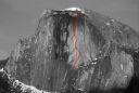
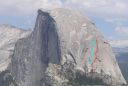
Regular Northwest Face, Half Dome 5.12 or 5.9 C1 |
||
Yosemite Valley, California USA | ||
|
Avg time to climb route: 3 days
Approach time: 3 hours Descent time: 4 hours Number of pitches: 23 Height of route: 2000' Overview
Because of the long approach and north-facing orientation, the Regular Route has an alpine quality not found on other popular Yosemite walls. The climbing starts off wandering at a low angle and gradually grows steeper and gets better. The last seven pitches are spectacular. Place one South Face of the Column on top of another one and you will get an idea of the Regular Northwest Face's length and difficulty.
Photos
- View all 167 photos of Regular Northwest Face as: Thumbnails | Slideshow
Climber Beta on Regular Northwest Face
Which SuperTopo guidebooks include a topo for Regular Northwest Face?
Find other routes like
Regular Northwest Face
First ascent history
The first day Royal Robbins, Mike Sherrick, and Jerry Gallwas climbed broken, lower angle initial pitches. A seemingly blank expanse of granite led to the next major features. Robbins overcame this section by placing seven bolts and then making the most audacious pendulum yet completed in Yosemite, on the Robbins Traverse.Above, the team found heads-up climbing through loose chockstone-choked chimneys. Two committing features, the Undercling Flake and Psych Flake, were especially unnerving and with good reasonyears later they would both depart from the wall! The fourth day presented the most strenuous section on the climb, the Zig Zags. Two hundred feet of difficult nailing up these elegant and steep corners brought the tired climbers to a claustrophobic alcove for the fourth bivy. Adding to their discom-fort that evening was the Visor, an enormous tiered roof that loomed above-possibly blocking passage to the summit. To their great relief a sliver of perfect granite dubbed Thank God Ledge materialized the next day, leading the climbers under the Visor to easier ground. On June 28, 1957, the evening of the fifth day Robbins, Gallwas, and Sherrick stood on the summit, having completed the most difficult wall in North America. Other history
In 1975, Jim Erickson and Art Higbee freed all but a short section of the route (above Thank God Ledge) at 5.12b. Leonard Coyne made first free ascent in 1979.Strategy
The key to enjoying this route is moving light and fast enough to bivy only once. Parties that take longer should prepare themselves for horrendous hauling and mediocre bivy ledges. Fast teams spend day one approaching the wall and fixing to Pitch 3, day two climbing to Big Sandy Ledge, and day three topping out and walking down. Slower parties spend two nights on the wall and endure an uncomfortable bivy at 6 or 11 and then Big Sandy. During the summer, two to five parties often converge at the base on a single day. Approach the climb early and plan on spending a day waiting for parties to thin out on the route. The climbing itself is technically easy at 5.8 C1, but being a solid 5.10 leader will increase your chances of success and make the climb more enjoyable. Retreat/Storm
Half Dome is more susceptible to poor weather than any other Valley big wall. During the late summer the edge of high Sierra thunderstorms can hit the face with rain, hail, wind and lightning. Retreat is relatively straightforward at any time by rappelling the route.Approach
There are two approaches: The John Muir Trail and The Slabs. Hiking the John Muir Trail from Happy Isles to the eastern shoulder of Half Dome (7.5 miles) and then following a climbers' trail to the base (0.5 miles) is the straightforward but grueling option. The Slabs, although technically more difficult, is much faster and can mean the difference between being first in line for the Northwest Face or fifth.The Slabs
This 2.5 mile approach takes 2-3 hours and gains 3,000 feet in elevation. About 1.1 miles are on hikers trail and 1.4 miles are on climbers trail that involve exposed terrain, fixed ropes, and occasional 4th class.Park at Curry Village. Take the shuttle bus to the Mirror Lake turnoff. Walk on the road for a few hundred yards to Tenaya Bridge, gain the trail east along the south shore of Tenaya Creek to Mirror Lake. From the west end of Mirror Lake (marked by a small spillway) continue a few hundred yards until you reach a dip in the trail followed by a large rotting log. Wander (you may or may not find the climbers trail) up the hill for another .25 miles until you hit the base of The Slabs. Work your way upward along the base of slabs until you reach a high point where a faint trail leads up, slightly to the right to an 80' 4th-class section through some trees. Continue right and then left for another 150' until you reach another slab and the first fixed ropes. From the top of the fixed ropes, continue up for 60' and then cut left across a narrow 150' catwalk that leads to the base of a boulder-strewn drainage. Move up the drainage to a point about 20' before the base of a slab, then head left up a 3rd-class section. A sandy trail at the top of the 3rd-class leads to the base of a large slab and then heads left to a large drainage. Cross the drainage gully and follow a faint trail that leads left and then cuts back right to the drainage. Follow the left edge of the drainage until you can cross right on a series of narrow 4" ledges above an exposed slab. Follow the right side of the drainage for 300' until you reach the base of a slab, and then cross left to the uppermost left side of the drainage to a steep fixed rope. If no fixed rope, negotiate the next slab by walking left along a ledge, and then cutting back right and up towards the east edge of the drainage. A faint trail leads up through bushes and to the right, back into the drainage and to the base of the next fixed ropes. After climbing the two steep, fixed ropes remain in the drainage for another 80', then exit right and join a trail about 20' from the edge of the drainage. Follow the trail up through a 30 steep bushy section and gradually left back across the mouth of the drainage and up towards the base of the wall. For Tis-sa-ack and all routes starting to the east, just before reaching the base, gain a faint trail that heads left and follows the base of the rock buttress through bushes, eventually ending at the base of the wall. Descending the Slabs approach
Either descend the way you approached or, before entering the gully for the first fixed rope, continue down the trail until reaching the edge of a cliff above the drainage and a tree with rap slings. A 50m rap brings you back to the regular approach/descent route.Descent
The nine-mile hikers trail offers the best descent from the summit. Everything You Need to Know About
Yosemite Valley
Search the internet for beta on
Regular Northwest Face
Links to related internet pages with info on Regular Northwest Face
|
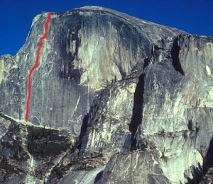 The Regular Northwest Face. Photo: Mark Kroese
Other Routes on Half Dome
|