Vasliki Ridge, Juno Tower |
||
Washington Pass, Washington, USA | ||
|
Avg time to climb route:
Approach time: Descent time: Number of pitches: N/A Height of route: Overview
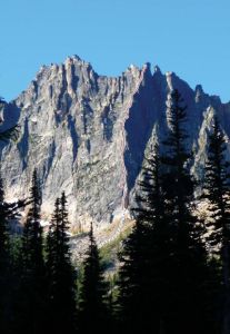
Vasiliki Ridge extends three miles north from the Wine Spires toward highway 20. When viewed from the Liberty Bell group, the ridge appears to be an unimpressive series of small towers and rocky ridges. But the view from the east is much more impressive, with walls and buttresses stretching vertically for nearly 1500 feet Rumor has it that Fred Beckey named the ridge Vasiliki after his one true love. Vasilki is also a Greek name for a woman in royalty. This Greek name for the ridge likely inspired the Greek themed names of the towers. Ares, Juno, Jupiter, Acropolis, Charon, Aphrodite, and Bacchus are all names of towers and summits along the Vasiliki ridge.Juno Tower (7,920 feet) isnt the tallest peak on Vasiliki ridge, but when viewed from the east, it has one of the more striking buttresses. The summit is easy to pick out by its two leaning summits that appear to tilt toward one another. The southern summit is Jupiter Tower and the northern summit is Juno Tower. Juno Tower is the only feature to have a Roman rather than a Greek name. Juno (the Greek equivalent is Hera) was married to the chief God, Jupiter (a Greek and Roman name), so it follows that the two closest towers would be named for them. Photos
- View all 1 photos of Vasliki Ridge as: Thumbnails | Slideshow
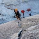
Climber Beta on Vasliki Ridge
Find other routes like
Vasliki Ridge
Approach
Via Burgundy Col: Drive slightly less than four miles east of Washington Pass to a very large, long pullout. Park near the east end of the pullout at an elevation of approximately 4,300 feet. At mile post 166 on the easterly end of the pullout, look for a trail leading down through the talus. The trail can be hard to spot. It is on the eastern end of an old slide path, and there are usually some cairns there. It is easier to see once it enters the trees; just make sure you get a visual before descending straight down the talus.Descend 250 feet down to a river (approximately 4,050 feet). This will seem more like a hike out. There is typically a good log crossing, but during peak water flow, you might have a short river ford and late in season when the water is low, you can hop across rocks. From the south end of the log crossing, there is an excellent, albeit steep, trail that goes straight up toward the Wine Spires. The trail ascends for 2,400 feet to a large bench where the trees open up at around 6,500 feet. There is a bolt on a boulder here and many good quality campsites. This is the Basin Camp. From the Bench Camp, dont take the faint trail northeast which leads to a spring. Instead, take the trail southeast up toward Burgundy Col. Continue on this excellent and easy to follow trail into a sandy gully. Then, about 750 feet above the camp, take the trail that heads right (south) across slabs and around short cliffs, before going straight up again. About 950 feet above the camp, go right again, and at 1,150 feet, go right and over the final sandy ridge feature. At this ridge feature, you can go down and across for the West Ridge of Piasano Pinnacle. But keep going up, gaining the main gully but staying on the left side of the gully below Burgundy Col. Above this, there are many sandy trails to choose from (snow in early season). The most solid trails tend to be on the left (north) side until around 200 feet below the col, where the more solid footing is on the right (south side). Follow these trails up to Burgundy Col. Burgundy Col (7,850 feet) descend 300 feet on steep snow (40 degrees). This snow is here all year round. Later in the season when the snow is firm, it can be easier to descend scree and some second class on the descenders left side where the snow usually melts out by mid-season. Finally, ascend up a short, loose third class gully above a slab to a large ledge with a single splitter crack running steeply upward. This marks the start of the route. Silver Star Creek: Drive to 8.5 miles east of Washington Pass to a small pullout at Silver Star Creek. You will see a sign for Silver Star Creek. There is a good climbers trail that rises steeply from the road, enters a talus field at around 4,850 feet and levels off as you travel southward. Travel cross country on scree and talus, cross the creek and ascend the western edge of the valley. At this point, the trail becomes discontinuous, breaded and difficult to follow. There is a swampy area toward the head of the valley that can be bypassed on the west end. Once near the head of the valley, follow game paths in a southerly direction up talus, devils club and slide alder, or snow in early season. Camping
Silver Star Creek Camp is at about 6,500 feet where the timber starts to open up and the terrain begins to flatten out. Finally, ascend up a short, loose third class gully above a slab to a large ledge with a single splitter crack running steeply upward. This marks the start of the route.Camping options: Bench Camp: (6,500 feet) There are many large tent platforms in this area. The Basin Camp is well-protected from the wind and gets nice afternoon sun but can be buggier than Burgundy Col. You can find running water year round about 200 yards from camp. On the south side of the camp, past the large boulder, there is an obvious trail leading east. Follow this good trail for about 200 yards to a spring. Sometimes the flow is low (bring a dippy cup in late season), but there is always some water flowing. Silver Star Creek Camp: (6,500 feet) This camp is mostly used when Silver Star Creek approach is covered in snow. At other times, it can be harder to find good camping there, but a few descent spots exist, even when the snow is gone. Look for the best spots where the timber gets thinner and the terrain flattens out around 6,400-6,500 feet. This camp has spectacular views of the massive east face of Vasiliki Ridge, The Wine Spires and the lower Silver Star Glacier. Generally, there is running water all summer long within a ten minute walk. This site is buggier than Burgundy Col. Descents
Back to the Bench camp: From the top of Juno tower, drop down a scree covered gully for several hundred feet. As the terrain starts to open up, make a descending traverse away from the highway (left, south). As you come around a rib, look for the flat area of the Basin Camp below Burgundy Col. Dont be tempted to traverse too far right too early; the bush whacking gets bad. Instead, work your way through mostly open woods and denser brush closer to the camp. Once in or near the Bench Camp, descend north on a good trail toward the car.Back to Silver Star Creek: From the summit, go west and drop straight down a few hundred vertical feet until you are able to start making a descending traverse northward on the west side of the ridge, traveling on scree, sand and talus. You will cross several scree covered ribs; dont be tempted to descend too much too early. At 7200 feet, go down the ridge crest on some third class steps with a tiny bit of fourth class. Dont venture on the east side of the ridge; the terrain is steeper and mossier. If you are down climbing fifth class rock, look around. There is a better way. Your goal is Sunset Col at 6,800 feet From Sunset Col, go down and left (north). There is a game path with no down climbing, just walking, on a scree covered and sandy trail. If you are thinking about rappelling, you went the wrong way. Go back. Descend until the terrain flattens out. From here, you can return to the base (about 10-15 minutes) or descend to the valley and back to the trail head. Everything You Need to Know About
Washington Pass
Search the internet for beta on
Vasliki Ridge
|
 Juno Tower Vasliki Ridge Photo: Ian Nicholson
Other Routes on Juno Tower
|