South Ridge, Black Peak II 4th Class |
||
Washington Pass, Washington, USA | ||
|
Avg time to climb route: 1-2 days
Approach time: 4-8 hours fr. W. Fork Airstrip Descent time: 4-6 hours Number of pitches: N/A Height of route: 1,000' Overview
This is a non-technical scramble with straightforward route finding that is a great introduction to Cascade climbing. It offers superb views and is ideal for building mountain experience or for a climber wanting a fun and relaxing trip. In mid-summer, the route has a lot of cross country travel and scree walking, but some short sections of 3rd and 4th class scrambling keep the South Ridge from being a true walk up. Early in the year, most of the South Ridge is covered in snow and ice which gives the route a more remote and alpine feel.
Photos
- View all 1 photos of South Ridge as: Thumbnails | Slideshow
Climber Beta on South Ridge
Find other routes like
South Ridge
History
The South Ridge was first climbed in 1926 by Lag Wernstedt and possibly Alfred Shull. This was long before the highway was built, and the pair made the lengthy hike in along the North Fork of Bridge Creek, west of the mountain. Herman Ulrich an avid explorer and prolific first ascentionist in the region, Ulrich actually soloed the South Ridge of Black peak in August 1934. He approached Black Peak via Lake Ann, which is now standard. As he started up the South Ridge he believed he was making the first ascent of the ridge and the mountain, only to find evidence of a previous ascent. Ulrich completed his ascent in 12 hours round trip, completely on cross country travel as there were no trails whatsoever, a feat impressive even to this day. Strategy
This route is semi-popular; on a weekend youll likely see another party and mid-week you will probably have it to yourself. The South Ridge is low angle and broad enough that, except for a few sections higher on the ridge, additional parties rarely create a hazard. Still, use caution. Passing is also easy at any point on the ridge. Once on the ridge, route finding is pretty straightforward with many possible options, and a climbers path is visible once most of the snow has melted from the ridge. There are also a lot of cairns to show the best way through certain crux steps. Once gaining the col from Wing Lake below the Southwest Ridge, the route finding is fairly straightforward. Climb up from here, and at about mid-height, traverse slightly left into a gully system that gets steeper as you climb higher. This is mostly Class 2 with short steps of Class 3 and 4. A few hundred feet below the summit, traverse back right (east) and ascend a final, 3rd class gully that finishes slightly to the east side of the peak. While the Southwest Ridge is climbed all summer long, it is most pleasantly climbed when the lower trails are snow free but the upper talus and scree fields are covered by snow. These are loose, sandy scree fields, and it can be a struggle to make upward progress through them. The slopes leading up to the col are steep, and if covered with snow can be firm, so an ice axe and crampons are recommended. Retreat/Storm
The ascent route is the descent route. Retreat at anytime by down climbing the route.
Everything You Need to Know About
Washington Pass
Search the internet for beta on
South Ridge
|
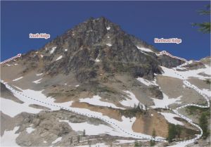 An overview of the routes. Photo: Ian Nicholson
Other Routes on Black Peak
|

