cat t.
climber
california
|
 |
The mosquitoes are out in droves right now and will definitely try to eat you alive. The descent back to saddlebag lake is amazing as of Aug 26--there's a ton of snow, but it's all low angle enough that you can easily boot-ski down and save your knees from all that downhill hiking!
|
jaredg
climber
california
|
|
I hiked past young lakes to camp at the base of the west ridge a couple weeks ago. Stream crossings and snow were no problem (there's a stream maybe a mile from Dog Lake that I ended up wading through on the way back -- I was too tired to look for a crossing). There were a couple snow patches on the descent but they're not steep. Mosquitos were bad.
|
TC61
Social climber
Los Angeles
|
|
Planning on doing the West Ridge next week (8/21/17) via Young Lakes. Wondering if anyone knows what the stream and snow conditions are are like on the approach and descent.
|
sol_dog
Trad climber
Oakland, CA
|
|
Anyone climbed conness this year? How's the snow levels and mosquitos?
|
Fletcher
Boulder climber
Institute of Better Bouldering-DirtbagDad Division
|
|
Hey Yogasquirrel!
I've never done actually done the West Ridge though not for lack of trying! I've *intended* to climb it almost more times than I can remember, but tales of woe and intrigue seem to intervene when it comes to me and this climb! Pretty much all ended up as type 2 fun and these stories are good for campfires and tossing back beers. :-)
That said, I concur with the wise munge and limpingcrab on taking a 60m rope. Definitely a good idea on alpine climbs of this kind... Especially when you want to run it out and make better time.
One of these days maybe I'll actually do it!
Eric
|
micronut
Trad climber
Fresno/Clovis, ca
|
|
Yogasquirrel I'd consider a single 60. The 60 lets you do noticeably longer pitches and in the event of raps lets you do more than a 50. The 50 is nice so as not to snag as much......but the route is really straight up and not really wandery. We did it with a single thinnish 60 and pitched out the entire route from base to top and made it to the summit in about 5 hours. I know many people stay unroped for lots of it and do it WAY faster, but we had a blast, and had no worries about time pitching the whole thing out and still making it back to camp in daylight. Have fun! Its a fantastic route!
|
Mungeclimber
Trad climber
Nothing creative to say
|
|
Longer is better if it isn't windy, or if you are ok with non verbal belay commands. Longer lets you do fewer belays.
|
YogaSquirrel
Trad climber
Los Angeles, CA
|
|
Hey any advice on what length rope to take?? considering a 50mm but any suggestions would be greatly appreciated
|
elAndy
Trad climber
El Portal, CA
|
|
I was climbing the West Ridge of Conness yesterday (7/17) and left my poles on top of a boulder right where the Saddlebag approach notch reaches the summit plateau. Upon returning to the notch on the way home, my poles were missing. I will assume the party who grabbed them had the best of intentions, however I would like them back. Incidentally, one of the poles had snapped moments before I stashed them, so they are semi-useless anyways.
If you have them, please email me at esparza(dot)ar(at)gmail(dot)com.
Thanks!
ae.
|
tahoemnts2
Trad climber
Truckee, CA
|
|
My buddy and I did the W Ridge up and descended the N Ridge and hiked out that way. Took 10.5 hrs car to car. We burned too much time by missing the best gully descent to the base of the W Ridge route and went too low down a further gully. Probably some better beta on how to find that gully to descent but we didn't do much research on it.
|
nathlem
Trad climber
MARIPOSA
|
|
we climbed this one on 6/24/2015. the little patches of snow there are you can just walk around it. the approche took us 5 hours. parked at sawmill and hiked from there. can't remember the name, but its the one you have to hike up pretty far, up a little gully or corner, then you got on some ridge from you have a great view of the west ridge of mt. connes. there we hiked down this really speed gully, even rappeled down one section, where we decided to leave a green sling, to make rapping easier and avoid getting the rope stuck up there.
awesome exposed ridge, amazing views onthe top. I was really beaten by the end of that day, especially with the hike out. the MOSQUTOES are serisouly a pain. I did had long pans and a long shirt, which made the heat so much worse, but at least gave some more protection from the sun, which was full on blasting.
the shirt was a little tight, so the mosquitoes just covered me with bites rigth through it.
there is a shorter trail up whish goes along a ridge, but its not that obviouse to find we thought, as we came down from it and looked back at it.
|
looks easy from here
climber
Santa Cruzish
|
|
Pic from the southwest, Wednesday 5/27/15
|
Chris McNamara
SuperTopo staff member

|
|
On 5/24 looked very snowy on the summit for both the approach and climb.
|
Bretts
Trad climber
San Diego, CA
|
|
Planning on doing the West Ridge 5/24, approaching from Sawmill. Any info on snow conditions out there? Crampons and ice axe a good idea?
|
Rattlesnake Arch
Social climber
Home is where we park it
|
|
Climbed WR Tuesday from Tuolumne Meadows via Young Lakes, where we camped 2 nights. Our GPS track showed 22 mi car-to-car including the approach, climb, and descent.
It being a west ridge, we were expecting to be in the shade all morning. Indeed it was cold when we started up, but by 10AM we were a few pitches up and (most gloriously!) in the sunshine.
|
gung-ho gun show
Mountain climber
Bend, OR
|
|
I climbed it on June 15th, approached over "North Peak Pass" from Saddlebag Lake, this is the pass between Conness and North Peak. Secor lists it as class 2, this is possible with lots of talus side hilling. You can go straight over the pass with an easy pitch of low 5th from behind the terminal moraine lake on Conness Glacier. Worked pretty well. Descended E Ridge and then shot off the north side to go down an easy snow field to Saddlebag. Guide tennies got wet, but not too bad. Route is very easy and mellow for the grade, lots of options in terms of difficulty and exposure. Well cairned/trailed walk-off.
http://mountainmischief.blogspot.com/2014/06/sierra-solo-part-1-conness-west-ridge.html
|
Soapy
Trad climber
SF, CA
|
|
Simul-climbed this route on Sunday. Still a couple snow fields / patches on the approach / descent, but nothing that stops you from (eventually) getting to the base. It was slippery going in the morning before the snow softened, but enough suncups to give you some footing. Obviously lots of streams are running so it's easy to refill as you go. Beautiful day out in the mountains!
I found a frozen men's mountain hardware jacket on the approach- looks like it had been there for the whole winter. It's still in good condition- looks almost brand new. Message me if it might be yours-otherwise I will donate to another climber.
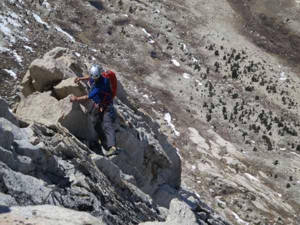
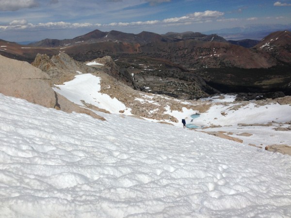
Here's a picture of the descent to give you an idea of conditions.
|
Mr_T
Trad climber
Northern California
|
|
Anyone know if there is any snow on the approach right now? Can I get by in non-goretex shoes? Going up Sunday.
The only recollection I have is from doing the route in Sept, 1996.
|
chick_on_ice
Trad climber
|
|
Soloed this route middle of June. Snow on the approach wasn't a problem (I wore sandals). I would be timely and try to move quickly if you're going to pitch out everything. I happened upon a bail anchor about halfway up, and I think the group must have ran out of time. Great route---watch out for the marmots if you're going to stash anything!
|
Andy Middleton
Trad climber
Cow Hampshire
|
|
Pretty much what GDavis says. You will need a bivy permit to camp at Young's lakes or anywhere in the vicinity. Depending on how the altitude effects you, figure close to two hours to the base from Young's. Once past the first couple pitches the climbing gets very easy and i would just simul-climb from there. There is a fairly well established climbers trail leading back to Young's from the summit plateau.
|
GDavis
Social climber
SOL CAL
|
|
Done it a few ways, if your camping get in at young lakes. The sawmill approach is brutal and the descent gulley loose and scary.
Come in from the young lakes and x-country travel to the base and descend the sandy SE slope to the little marsh (class 1-2). The climb itself is VERY low angle with abundant crack systems and stellar rock. Very similar to tenaya peak w/more exposure and less class 5. Get er done my friend it's a blast!! Many ways to pass/be passed as well.
|
gizzard
Trad climber
sacrramento
|
|
hey guys,
Im taking my GF on this route next saturday..
we are going to camp looks like about a hour away.
Curious...how popular is this? and should we start our hike out of camp at dawn?
how much will we need to rope up? should i should prep for using a rope and running it out over 5.6 and less terrain to keep us moving quickly?
last question. how is the descent? any snow right now?
thanks sooo much
Ive climbed North Catherdral Spire in Yosemite..but this appears to be a great route for me and my girl and at a easier rating. any heads up would be great.
thanks!!
|
Mungeclimber
Trad climber
Nothing creative to say
|
|
Pitched this out with Angus this last Saturday with a touch of simul. Totally worth the hump out there. Started at 5am-ish from Sawmill, leisurely pace, and hung out at the summit for awhile. Got back after dark around 8pm ish.
Used a lightweight lead line 8.9, single set of stoppers, red alien, single green, red camalots, and double gold camalots, and used 10 alpine draws, tying in with cloves on the rope, and that seemed to be just right.
Stashing a water filter just before going up the first ridge out of the approach valley is a good idea if going c2c. If it's hot, bring extra water. Temps were in the high 60s on our ascent.
The left arete looks better than staying in the trough when starting the route (see more terrain as you climb).
It's definitely a big day, so unless you trail run at elevation and start at midnight don't do this one if there is any chance of storms or clouds start forming up.
Great line to finally do. On to the next one...
|
JohnH
Trad climber
Mill Valley
|
|
Anyone done this lately? Conditions on approach and climb?
Thanks,
John
|
wstmrnclmr
Social climber
Air B&B Town, USA
|
|
The beta post from McNamera dated from 2008 denoting a "significant error" as to the approach to this climb should be bumped every 6 hrs. by the meathead who wrote the guidebook info. My girlfriend and her partner wasted three hrs. getting to the base basically blowing the route for them. Snow on the ridge and in the gullies. They GPS'd there way across easy, snowless terrain back to Young Lake in an hour and a half! This route gets done frequently. Instead of a "significant error" it should be called a "complete F-up".
|
schaffner
Trad climber
|
|
Does the newest version (2010) of the Tuolume Free Climbs book still contain the same mistake regarding the approach via Young Lakes?
|
enjoimx
Trad climber
Yosemite
|
|
Soloed this route with a buddy September 20th 2008. Windy but warm and sunny all day.
On the first pitch I would recommend going left around the corner to start the ridge as opposed to starting in the giant amphitheater type weakness at the toe of the ridge. Going left makes it slightly easier and better suited for soloing at a mellow 5.6 grade.
On the first pitch, we went right up some vertical fin type things for about 60 feet before we realized we were off route. We learned a huge lesson that when onsight soloing, be sure you can downclimb ANYTHING you can climb up unless you are 100% sure where the route goes.
We slowly and meticulously climbed back down and went left around the corner and had a stellar, 1.5 hour romp up the beautiful west ridge.
|
Chris McNamara
SuperTopo staff member
|
|
CORRECTION TO THE TUOLUMNE FREE CLIMBS AND HIGH SIERRA BOOK
There is a significant error in the Supertopo. The approach from Young Lakes is along the flats (lower left corner, then by the tiny ponds shown in the topo). The error is copied from a similar error in the Tuolumne guide. I think we messed up because the Tuolumne guide has a topo key box (and a compass symbol) directly over where the approach should be shown, and the line was placed on the wrong side of the box, then copied in the High Sierra guide. So you found an error in two of our guidebooks!
The approach from Young Lakes is very easy and straightforward along beautiful open country with lots of flat rocks and small meadows - like you thought, there's no reason at all to head up to the ridge.
Thanks for letting us know about the mistake!
Greg Barnes, Tuolumne Supertopo author
the above response is to this question:
Im getting ready to do the West Ridge of Conness with the family, and trying to get beta on the approach via Young Lakes. Several web accounts suggest hiking to the base directly through the woods, but your High Sierra Climbing topo on page 133 shows hiking to the notch on the Carnegie Institute approach and then dropping down to the west, past the south face seems like a lot of extra elevation gain and loss?
|
BluntMan
Gym climber
Wild Omar, CA
|
|
Did this route yesterday (7-7-2007) with Charlie. Hiked in from Sawmill Campground. As mentioned in the topo, the approach is a bit tricky but if you bring a compass and a copy of the map in the supertopo guide, you shouldn't have much trouble. It's a big approach...start early or be in good shape.
Lots of variations but we stayed on the ridge the entire route. That's where the best climbing is and where you'll find the most exposure. One series of moves about 3/4 the ways up up is particularly good....thin but easy finger crack that leads to the outside of the ridge where you'll do a super exposed but easy hand-sized crack traverse. There's also one cool diving board section that you can look down and see the entire SW face..awesome.
|
Chris McNamara
SuperTopo staff member
|
|
just got this note from a yosemite ranger
I was climbing conness the other day and noticed that you recomend in your book to camp at alpine lake on the east side of conness. I wanted to tell you that alpine lake is within the hall research natural area. It has been a vegetative research area for over 30 years and camping has been prohibited there for a long time.
|
Old&InTheWay
Trad climber
NC
|
|
Climbed this fantastic route car-to-car last week. The approach and descent are what make the grade IV. If not for the approach, this route would be more popular than Royal Arches. The quality of the rock and position are outstanding. Bato and I simul-climbed the ridge in less than 2 hours.
|
Ney Grant
Trad climber
Pollock Pines
|
|
July 23, 2005. Still lots of snow, although route clear. We did alpine start and had crampons, which were helpful on the icy snow. But we saw many parties that came through later when the snow was softer that didn't have anything (Hiking poles would be very handy if nothing else).
Mosquitos are absolutely mind boggling. They were wicked up to almost 11,000 feet. What do they eat up there when climbers are not around?
|
Russ
Trad climber
Ventura, CA
|
|
Did the route Sept 15th and found the SuperTopo rating and beta to be right on! Excellent fun on clean rock. Agree with others though that it was over a little too soon given the length of the approach. We camped at upper Young Lake and it was still a 2-3 mile approach from there.
|
Chris McNamara
SuperTopo staff member
|
|
The supertopo beta suggests that camping is allowed at Alpine Lake. However, camping here is illegal, and is not permitted, and permits will not be issued by Yosemite for camping in Hall Natural Area. THe beta seems to endorse camping here, and i would suggest this be omitted in a future version of the supertopo. In my opinion, the only good option for camping is approaching from the East is at saddlebag, or in the walk in campground; besides, alpine lake is only ~1 hours hike from this spot!
|
moabbeth
Trad climber
Los Angeles/Moab
|
|
Did this climb Saturday. Fun fun. The only reason I can think why this would be a Grade IV climb is the time for the approach/descent. The climb itself took us just under 2 hours, brought a short rope and only roped for a couple short sections where the exposure was just too much for my newbie freesoloing head. And it goes just fine in approach shoes, never even needed the climbing shoes cause the rock was such good quality. We passed one party of three who were fully geared up climbing and sewing the rock up, but it was easy to climb right past them. No one else on the route above us after that point. If you keep moving, this climb is over before you know it.
Make sure you get the correct gully on the approach hike once you've cleared the (almost) summit. It's well marked with cairns once you get close enough to it. Some guys who were on the trail ahead of us missed the gully and went a looooooong way around. We were already about 4 pitches up by the time they arrived at the base.
The view from the summit is one of the most beautiful views I've seen in Tuolumne. It was a little hazy in the distance cause of the recent brushfires but you could still see well past Cathedral, Matthes on to Half Dome. We lucked out, the weather was awesome.
Would I do this again soon? Probably not. It's a committing day of a lot of hiking and not too much climbing in relation to the amount of time spent hiking. But is it worth doing? HELL YEAH! But if I wanted to go do a ridgeline climb again, I'd probably do Lone Pine Peak again before this one...I just like 'em long and committing.
|
Jedi
Trad climber
Upland, CA
|
|
One of the best ridges I've climbed in the Sierra to date. Headed up the North Ridge with a buddy then headed down the gully to the West Ridge while he rested on top. I started left of what the ST guide says. There were people all over that side. Great solo and Great exposure!*
The descent took some time. We headed through West Nile Virus valley, then took a wrong turn near the end. A cairn at that point would be great. I guess the next time I head up to do the SW face I'll throw one down.
|
Ed Hartouni
Trad climber
Livermore, CA
|
|
Gary and I did this, we drove up from Livermore and started hiking at Sawmill sometime around 7:30am on 7/27/02. We took 4 hours to hike to the base of the West Ridge. We hit it right on but the approach from this direction is definitely the crux of the climb. It is very easy to get lost.
The climb took something like 4 hours, but it would have been slightly faster if we had not had to wait in line behind many other teams. Once we exited the lower ridge we passed everyone else simul-climbing the upper half of the ridge.
From the summit we descended to the car in about 3.5 hours. We ate at the TPR that night and slept well in my Westie at the Tioga Lake Overlook...
My notes on the approach:
"Hike on the "road" towards the Carniege Institute buildings. This is a valley draining southeast side of Mt. Conness. Continue up valley to S. Ridge. Aim for low point. Work up boulders and find easiest notch through. On the ridge is 11,200'. Contour around the plateau and slightly up to notch in W. side of the ridge, 11,400'. This notch is top of creek which drains plateau. Creek forks down around promenence in ridge, descend west most. Delicately descend staying close to creek. A granite bench will appear right (North). Work over to bench and contour into Southwest wall area around spur. West Ridge very promenent once around ridge. Contour around to scree slope start of West Ridge."
|
Sean
Trad climber
Ashland, OR
|
|
A question. The guide book seems to indicate that the two options for a climb of the west ridge would be to go car to car from Sawmill Campground or over night at Youngs Lake. Is it possible to come in from Sawmill and bivy along the approach somewhere or is camping prohibited in that area?
|
BR
Trad climber
The LBC
|
|
I had a go at this with two other partners last weekend, but wound up bailing 4 pitches up because we weren't moving quickly enough. A few thoughts:
1. If you're coming from Young Lakes, the supertopo's approach info is fairly murky. From the lowest lake, you can pretty much pick a straight line toward the left side of the SW face. Once you hit the long meadow beneath the face, the route will be pretty clear. Down low, the ridge splits in two ... you probably want to head up the one on the left. Approach by scrambling up the talus cone in the middle, find a good spot to flake the rope, and head up and left to start the climbing. Some of the approach looks a bit improbable from a distance, but it's really pretty simple once you're there. Even with the backpack into Young Lakes, the approach is a long one -- figure 2 to 2 1/2 hours for the approach.
2. If you're going to rope up for all 12 pitches, the time estimate of 3-5 hours to climb the route may be a bit on the quick side. We were moving exceptionally slowly, given that we were attempting the climb in a group of 3, none of whom had any experience on technical Sierra rock other than Cathedral Peak. Several people we talked to, though, including a horse-packer who is in the area frequently, mentioned that parties routinely get back to camp after dark. Supertopo mentions that the West Ridge is a step up in difficulty from Cathedral Peak -- it's a significant step. Peter Croft's book calls this thing a Grade IV, so you may want to plan accordingly.
3. Retreat from 4 pitches up wasn't too taxing, although it did require us to leave a few stoppers and some webbing, and took quite awhile. Had we kept climbing another pitch or two, however, it looked like the raps would've gotten significantly tougher, and run through a lot more potential rockfall hazard. There's a ton of fixed gear in the gully west of the route, ranging from fixed bomber pieces taht we were comfortable using to fixed mank I was afraid to touch, to loose gear lying around in the talus. I scored a Petzl locking biner (which I later recycled by leaving at our last rap station) and an old museum piece Chouinard #2 Camalot (pre-Black Diamond) that I wouldn't trust to climb on, but I will keep around.
All that said, it's a spectacular line, on beautiful, solid Sierra granite. I can't wait to get back and try it again with a little more Sierra experience under my belt and a quicker, lighter, two-person rope team.
On a lighter note, we ran into Linc on the Young Lakes trail as we were hiking in ... he and Naomi climbed the route and camped at Roosevelt Lake the day before our attempt. Linc, it was great to finally put a face with the name! Hopefully, I'll be out your way again soon.
|
Andy Middleton
Trad climber
Cow Hampshire
|
|
You don't need a permit for climbing, but you will need one for a bivy. I'm not sure but i think the south & south eastern flanks of Mt Conness are off limits for camping. In any case, you'll probably need to contact the YNP to get a permit.
|
Chalkbag
Trad climber
cameron park, ca
|
|
Here's a logistics question, is a wilderness permit required for climbing Mt. Conness and North Peak? How about staying over night? is Mt. Dana a similar situation? also, does any one know where to check the availability of wilderness permits? I know there is a quota for certain areas. Any help would be great.
|
Chalkbag
Trad climber
cameron park, ca
|
|
Here's a logistics question, is a wilderness permit required for climbing Mt. Conness and North Peak? How about staying over night? is Mt. Dana a similar situation? also, does any one know where to check the availability of wilderness permits? I know there is a quota for certain areas. Any help would be great.
chalkbag
|
jmartin
climber
|
|
Of course it will be in shape in July, that's right in the middle of the season!
|
BR
Trad climber
The LBC
|
|
Any advice on when this climb comes into shape? I'm trying to convince a buddy to do it the second weekend in July. If we go, we'll do it as a backpack, spending the night before at Young Lakes, so the snowfield on the approach won't be an issue. I assume that, it being a west ridge that we'd approach from the south, it should be ok -- anyone think differently?
|
Chris McNamara
SuperTopo staff member
|
|
The American Safe Climbing Assn. may have replaced anchor bolts on this climb. To find out visit the ASCA Replacement Page
The ASCA is a non-profit organization dedicated to replacing unsafe anchors. To learn about helping the ASCA click here
DONATE NOW
|
Justin Black
Mountain climber
Bishop, CA
|
|
We approached the West Ridge on 7/6/2003 from the Sawmill Campground below Saddlebag Lake. It is still early season and rather boggy in the drainage, so mosquitos were fierce! Right now, the notch in the Southeast ridge is reached via a fairly long, sun-cupped snow slope, which I guess won't melt out until August. The slope is easily climbed in approach shoes unless you start up it before the sun has had a chance to soften it up a bit.
Following the Supertopo approach down the backside 3rd class scree chute on the way to the West Ridge butress works well, but I'd recommend quickly skirting completely below the slabs at the bottom rather than wasting time searching for the elusive 3rd class descent down the headwall. There is also what looks like a reasonable 3rd/4th class gully entered via a notch at the top of the West Face... not sure which way is faster.
We did start about 100' left of the original start, which involved some basic route finding on the first pitch, but as long as you aim for the ridgecrest, you'll end up on the knife edge ridge and on to the summit. The climbing is interesting but easy throughout, allowing you to focus on the wonderful continuous movement, amazing views, and fantastic exposure on the ridgeline. Looking down on the West Face is one of the most beautiful sights I've ever seen.
Our group of three simul-climbed the route, and use of the multitude of excellent nut placements allowed us to break the climb into about four pitches. If we had brought more nuts and slings in place of the #3 cam, we would probably have only had to re-rack three times.
The Supertopo was accurate and confidence inspiring as always!
|
Bob
Novice climber
Bishop, CA
|
|
There's a faint trail from Saddlebag, but the trail from Sawmill Campground is better. Head west along the South side of the East Ridge to the Summit plateau. In a day from the car is the way to go. Does anyone actually approach this route with a bivy?
|
| | | | | | | | | | | | | | | | | | | | | | | | | | | | | | | | | | | | | | | | | | | | | | | |