Trip Report
Half Dome Like You're Never Seen it Before
|
Wednesday April 16, 2014 4:49pm
|
|
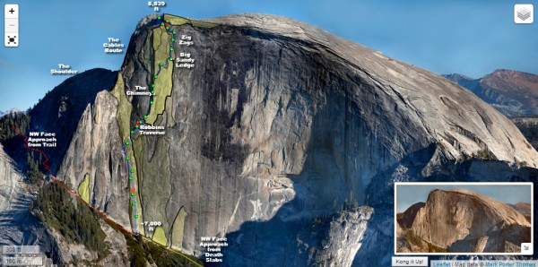
Interactive Half Dome Map App
(Make sure to go full screen for the best experience. Zoom in, pan around, turn layers on and off, click photo icons to see image thumbnails in popups, click the thumbnails to see the images enlarged. Most items have mouseover tooltips, and what you see changes upon zoom level.)
Last Fall I had an idea for making a unique style of trip report that provides an interactive first-person POV experience, merged with the birds-eye view of the route traveled. I had already climbed the route with my friend Nic Risser, sleeping atop Big Sandy for my 30th BDay in August, so I also had photo documentation of the route.
I had no idea how I would do this, apart from knowing that I needed photo material to work with and would have to learn JavaScript to implement it. So on my last weekend out before my first of 3 knee surgeries, I hiked to the summit of North Dome with my camera and took a lot of closeup shots of Half Dome, and during my down time this winter, I figured out how to make this idea a reality.
The project is still very much unfinished (and yes, Justin, I still need to add photos from your climb!), but it is working, and really fun as-is, and I see myself waiting too long before sharing it if I wait until it is 'finished'. So click below!
Interactive Half Dome Map App
Process
I created the image with photos taken using a 7-year-old Nikon D40 DLSR, with a Nikkor kit lens. (55-200mm zoom). I merged the image together in Adobe Photoshop, but not without some trial and error for such a big project.
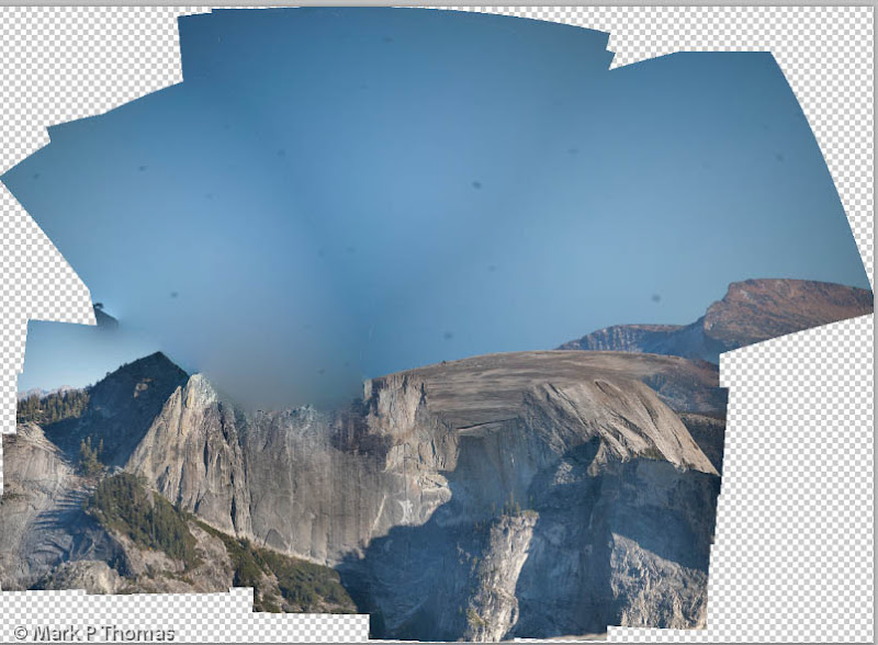 Visit on googleusercontent.com Visit on googleusercontent.com
Result of attempting to blend all of the photos at once in Adobe Photoshop.
However, with some experimentation, I found a way to get the merging to work correctly.
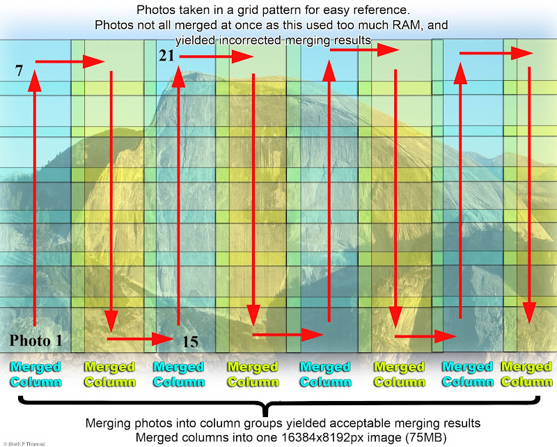 Visit on googleusercontent.com Visit on googleusercontent.com
NW Face of Half Dome, roughly as I had divided it up into close up photographs taken with a 200mm zoom lens.
Once the image was assembled, I had the problem that the image was 75MB, which took far too long to load on a web browser to be a feasible way for a user to quickly view the image. There are a number of JavaScript methods & plugins for photo enlarging, but most did not allow some form of interactivity on the map that would scale and pan with the image.
I spent some time trying out one that could handle keeping image maps scaled and aligned with the image, but it was appearing to be a dead end.
So I tried tiling, which handles the size and sizing issues. Using this system also allowed for using various interactive elements (icons, polylines, shapes), positioned by latitude longitude coordinates, as this system is normally used for maps. Since my project was a flat image and not a curved 3D surface on Earth, I had to write some 'unproject' methods in my scripts, but otherwise everything worked together smoothly.
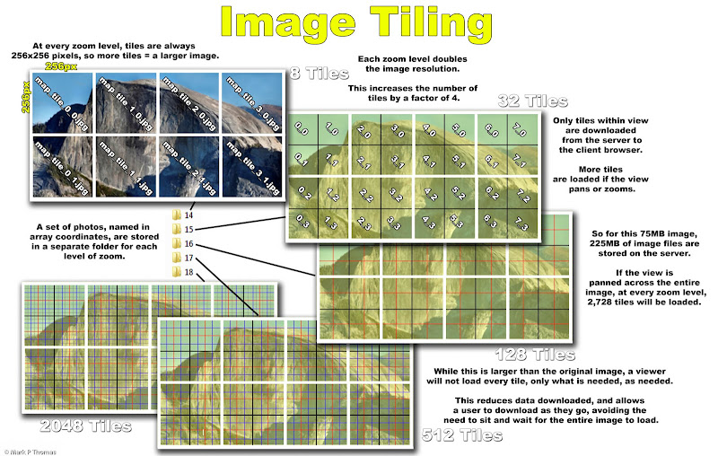 Visit on googleusercontent.com Visit on googleusercontent.com
I used Tiling to make to make the high resolution Half Dome image feasible for web viewing, with panning and zoom navigation. This is the same technique that Google Maps uses.
The tiling was done using a free Ruby script that automates the process, taking a few seconds to size, crop, and save the files in a format & folder structure that can be read by code for automatically re-assembling the portions of the image that are in view of your screen. There are various Ruby and Python scripts available to do such things, although figuring out how to get them to work is tedious (I really don't know either programming language).
And now, for those who just want to see some pretty pics . . .
2013-10-20 - Solo Top Rope and North Dome Hike
This was my last weekend to get out in the mountains before I would have the first of several knee surgeries that would keep me away from rigorous outdoor fun for the next year. As no one was game for getting out with me this weekend, I threw together my own last-minute plans for a Sunday daytrip: First, work out a system for solo top-roping at Knob Hill. Then hike to Indian Rock and Arch, and then to North Dome, for researching an approach and getting some project shots of surrounding features - especially the N Face of Half Dome. I hung out with a book and beer atop North Dome to catch the sunset before hiking back in the dark.
 Visit on googleusercontent.com Visit on googleusercontent.com
Arch near Indian Rock.
 Visit on googleusercontent.com Visit on googleusercontent.com
Half Dome and Starr King seen through the arch near Indian Rock.
 Visit on googleusercontent.com Visit on googleusercontent.com
Cloud's Rest and Quarter Dome (right, low) above the rugged Tenaya Canyon.
 Visit on googleusercontent.com Visit on googleusercontent.com
Tenaya Canyon, with Basket Dome (left), Mt Watkins (left, back), Cloud's Rest (center) and Half Dome (right).
 Visit on googleusercontent.com Visit on googleusercontent.com
Climbers finishing Thank God Ledge on Half Dome, seen from North Dome.
 Visit on googleusercontent.com Visit on googleusercontent.com
Climbers on the second to last pitch of the NWRR of Half Dome.
 Visit on googleusercontent.com Visit on googleusercontent.com
Watkins Pinnacles.
 Visit on googleusercontent.com Visit on googleusercontent.com
Panorama of Tenaya Canyon. Mt Watkins (left, low), Cloud's Rest, Quarter Dome, Half Dome, and Mt Starr King (right, horizon).
 Visit on googleusercontent.com Visit on googleusercontent.com
Half Dome's NW Face at sunset.
 Visit on googleusercontent.com Visit on googleusercontent.com
Sunset over El Cap from atop North Dome.
 Visit on googleusercontent.com Visit on googleusercontent.com
Afterglow lighting on dike ripples as I hiked out above North Dome to my car, parked on Highway 120.
Links
 Picasa Album (N Dome Hike)
Half Dome NWRR Picasa Album (N Dome Hike)
Half Dome NWRR
| |
Trip Report Views: 19,240 |
 PellucidWombat
|
|
About the Author
PellucidWombat is a mountain climber from Berkeley, CA. |
Comments
Roxy
Trad climber
CA Central Coast
|
|
|
|
Apr 16, 2014 - 05:09pm PT
|
I wonder how many hours I'll salt away on that HD interactive map.
I love that kinda sh!t.
Just curious, are there routes up Cloud's Rest? I haven't been close enough to know how steep it is, if technical climbing is even possibility.
|
|
looks easy from here
climber
Santa Cruzish
|
|
|
|
Apr 16, 2014 - 05:13pm PT
|
That's amazing! Thanks.
You can pan around, and zoom in closely enough to see climbers. I've found two parties. Can you find them?
I have 1 climber on Snake Dike, so far.
|
|
WyoRockMan
climber
Grizzlyville, WY
|
|
|
|
Apr 16, 2014 - 05:14pm PT
|
Excellent! As usual. TFPU
|
|
bpope
climber
Mountain View, CA
|
|
|
|
Apr 16, 2014 - 05:35pm PT
|
Just curious, are there routes up Cloud's Rest? I haven't been close enough to know how steep it is, if technical climbing is even possibility.
there sure are! look around for "my favorite things" for a more recent example. there are some long, wandering easier routes, I believe too.
thanks for the great report and map!
|
|
Texplorer
Trad climber
Sacramento
|
|
|
|
Apr 16, 2014 - 05:36pm PT
|
What a great concept. With the age of smart phones upon us I see guidebooks like this in the palm of your hand as the future.
|
|
KP Ariza
climber
SCC
|
|
|
|
Apr 16, 2014 - 05:36pm PT
|
Really good look, thanks!
|
|
PellucidWombat
Mountain climber
Draperderr, by Bangerter, Utah
|
|
|
Author's Reply
|
Apr 16, 2014 - 05:39pm PT
|
With the age of smart phones upon us I see guidebooks like this in the palm of your hand as the future.
It works fairly well on smart tablets . . . barely on smart phones, but I know in general what can be done to make it work better on that format. In your palm, high res map app of El Cap, anyone? With 3G/4G service in the valley, you can use it on route :-)
|
|
westhegimp
Social climber
granada hills
|
|
|
|
Apr 16, 2014 - 06:36pm PT
|
Outstanding!!!!!!!!!!
Thanks
Wes
|
|
overwatch
climber
Arizona
|
|
|
|
Apr 16, 2014 - 06:38pm PT
|
That is a high speed idea...can't wait to mess with it
|
|
Matt's
climber
|
|
|
|
Apr 16, 2014 - 06:45pm PT
|
pretty interesting app and photos. thanks for sharing.
I find it weird that, in the comments on your photos, you despair over the ramifications of "over-communication of route beta, " yet your trip reports pretty much epitomize this problem.
|
|
PellucidWombat
Mountain climber
Draperderr, by Bangerter, Utah
|
|
|
Author's Reply
|
Apr 16, 2014 - 06:59pm PT
|
you despair over the ramifications
That quote is not mine, but Nic's (see caption & photo credit). Seemed a nice thing to keep with his beautiful photo.
I feel some sentiments towards that, can appreciate the feeling, but I think there is plenty out there where you can still do this . . . just not as conveniently accessible as it was in the mid 20th century. I feel a stronger pull to sharing the experience. Even with lots of beta out there, I can still create my own adventure, and it's not that hard to get away from the crowds!
|
|
JohnnyG
climber
|
|
|
|
Apr 16, 2014 - 07:07pm PT
|
very very very cool.
That's a super high res shot of half dome. How did you take that pic?
|
|
PellucidWombat
Mountain climber
Draperderr, by Bangerter, Utah
|
|
|
Author's Reply
|
Apr 16, 2014 - 08:24pm PT
|
I used a DSLR with a 200mm zoom lens, and took photographs as I zoomed in as much as I could, in an overlapping grid order (the two closeup shots of climbers in the 'extra' report are individual shots, cropped and enlarged a bit).
I then merged all 20 or so shots in Photoshop, creating a 75MB image file . . . which ended up being the first hurdle to get over, as it would take several minutes or more to load the image online! So I went the 'map tiles' route for making load times reasonable.
|
|
Jingy
climber
Random Nobody
|
|
|
|
Apr 16, 2014 - 09:20pm PT
|
very cool...
Thanks for the report.
|
|
Ezra Ellis
Trad climber
North wet, and Da souf
|
|
|
|
Apr 16, 2014 - 09:43pm PT
|
Thanks Mark, I hope your knee is healing up well!!!!
|
|
Kalimon
Social climber
Ridgway, CO
|
|
|
|
Apr 16, 2014 - 10:06pm PT
|
Nice shots PW . . . thanks again.
|
|
Roxy
Trad climber
CA Central Coast
|
|
|
|
Apr 16, 2014 - 10:25pm PT
|
thanks, bpope
|
|
alleyehave
Trad climber
San Diego, CA
|
|
|
|
Apr 16, 2014 - 11:16pm PT
|
Nice Mark, TFPU!
|
|
SC seagoat
Trad climber
Santa Cruz, Moab, Bozeman, the ocean, or ?
|
|
|
|
Apr 17, 2014 - 12:47am PT
|
Man, I see your name on a trip report I can't click quickly enough.
Awesome...wonderful...all the best expletives!
Thanks for taking the time to do a great report...oh yeah...and having a wonderful adventure.
Susan
|
|
Peter Haan
Trad climber
Wyoming
|
|
|
|
Apr 17, 2014 - 12:57am PT
|
Extraordinary, Pellucid Wombat. Wow.
|
|
mouse from merced
Trad climber
The finger of fate, my friends, is fickle.
|
|
|
|
Apr 17, 2014 - 01:03am PT
|
Your main effort is grand, and your extra credit work is much appreciated. It's amazing what a 200mm lens can do. good luck with the knee, too.
|
|
Mungeclimber
Trad climber
Nothing creative to say
|
|
|
|
Apr 17, 2014 - 01:46am PT
|
thx! looking forward to doing this one.
|
|
thebravecowboy
climber
The Good Places
|
|
|
|
Apr 17, 2014 - 01:50am PT
|
thank you! yos beckons yet and you feed the fire
|
|
mark miller
Social climber
Reno
|
|
|
|
Apr 17, 2014 - 01:55am PT
|
being in my second year of graphic communications...."nice" only touches the surface...Very well done sir.
|
|
Clint Cummins
Trad climber
SF Bay area, CA
|
|
|
|
Apr 17, 2014 - 02:37am PT
|
Nice job, Mark.
I like the ideas of being able to zoom and to turn off the layers.
I would skip the tinted Features layer.
I think it works better as a style of guidebook than a vehicle for framing trip reports.
(For trip reports I like mixed photos and text with all photos visible).
|
|
mark miller
Social climber
Reno
|
|
|
|
Apr 17, 2014 - 02:41am PT
|
By the way, what camera, Lens, etc., and photo editing program do you use?
|
|
PellucidWombat
Mountain climber
Draperderr, by Bangerter, Utah
|
|
|
Author's Reply
|
Apr 17, 2014 - 03:30am PT
|
Clint,
I would skip the tinted Features layer. Yeah, I was on the fence about it as an experiment. It shows some features nicely, but it also gets in the way of viewing the photograph. I'm wondering if some people find it helpful in some ways, such that it is worth keeping, but with the default setting being turned off?
I think it works better as a style of guidebook than a vehicle for framing trip reports. For more of a storytelling device, with photos in the right order, I agree that it seems to be weaker this way (one reason I still kept a link for a standard format TR, although I need to fill in more story).
Filling in TR photos that essentially constitute beta seems to work well in the format as more of a guidebook. I'll see this better as I add in some friends' photos of parts of the route that I missed out on.
I did try representing the photo icons as mini thumbnails, like a small stack of photos, almost like what you can see in Google Earth user-submitted photos, but I thought the look became too cluttered.
Note: I apologize in advance to anyone who might care regarding the Comic-sans script. I intend to replace it with a similar font that does not have such a polarizing effect & tainted past. I just wanted a good 'bold' font that was more interesting than Arial Black for the time being.
Mark,
By the way, what camera, Lens, etc., and photo editing program do you use?
Nothing too fancy these days, camera-wise. A 7-year-old Nikon D40 DLSR, with a Nikkor kit lens. (55-200mm zoom).
I merged the image together in Adobe Photoshop, but not without some trial and error for such a big project :-)
Obamacare gets the government to shut down our national parks, and Half Dome Falls down from lack of maintenance!! (actually this was an auto-photomerge gone wrong :-P ) (Photo taken shortly after Gov. shutdown. I couldn't resist making this comment tongue-in-cheek)
To get tiling to work, I actually have a lot of smaller images cropped, with separate sets for each level of zoom. Each image that loads is 256x256px, covering whatever amount of the image fits within that size at a certain resolution (so tiles at closer zooms are the same size, but higher resolution, so show less area in finer detail).
This was done using a free Ruby script that automates the process, taking a few seconds to size, crop, and save the files in a format & folder structure that can be read by code for automatically re-assembling the portions of the image that are in view of your screen. There are various Ruby and Python scripts available to do such things, although figuring out how to get them to work is tedious (I really don't know either programming language).
Tiling is precisely how Google Maps works for its imagery, btw. Neat to learn about!
|
|
PellucidWombat
Mountain climber
Draperderr, by Bangerter, Utah
|
|
|
Author's Reply
|
Apr 21, 2014 - 12:26pm PT
|
For those curious about how the image was made, I added a 'process' portion in the trip report, with some illustrative diagrams.
As I get time I'll be adjusting and finishing up the project, so constructive feedback is welcome, as ultimately my aim is to make something that others find useful and enjoyable!
|
|
RP3
Big Wall climber
Newbury Park
|
|
|
|
Apr 21, 2014 - 01:42pm PT
|
This is truly amazing work. Your effort was monumental. Thank you so much for sharing. I absolutely see this as the future of guidebooks.
Suggestion: You should put a key inside of the app so people know what your symbology means.
|
|
PellucidWombat
Mountain climber
Draperderr, by Bangerter, Utah
|
|
|
Author's Reply
|
Apr 21, 2014 - 02:06pm PT
|
Good idea! While my aim is to make things as self-explanatory as possible, it is tough to tell where some explanation is needed for people first encountering the project.
I could probably integrate it into the scales in the lower left corner . .. maybe just a 'key' icon that expands to show a map key if a user moves the mouse over to it, similar to the layers icon. That way it is accessible without being intrusive.
|
|
Risk
Mountain climber
Marooned, 855 miles from Tuolumne Meadows
|
|
|
|
Apr 21, 2014 - 09:03pm PT
|
Really great! Thanks!
|
|
jTaylor
climber
North Shore Massachusetts
|
|
quality post
|
|
JEleazarian
Trad climber
Fresno CA
|
|
Thanks for bumping this exceptional post.
John
|
|
jaaan
Trad climber
Chamonix, France
|
|
The photo isn't interactive for me - it doesn't do anything...
|
|
bluering
Trad climber
Santa Clara, CA
|
|
pretty cool.
Anybody see the Sasquatch in the crescent near Snake Dike?
|
|
PellucidWombat
Mountain climber
Draperderr, by Bangerter, Utah
|
|
|
Author's Reply
|
May 9, 2014 - 03:21pm PT
|
The photo isn't interactive for me - it doesn't do anything...
Make sure to click either one of the Interactive Half Dome Map App links and not the photo on this page. I can't embed this on SuperTopo, so you have to click the link to go to the site where this is hosted. Sorry!
|
|
Ghost
climber
A long way from where I started
|
|
Nifty. Now if only I had enough spare time to really play with it...
|
|
jaaan
Trad climber
Chamonix, France
|
|
Ah, that's better, thanks!
|
|
PellucidWombat
Mountain climber
Draperderr, by Bangerter, Utah
|
|
|
Author's Reply
|
Mar 27, 2018 - 10:58pm PT
|
Update to my prior comment. The project can now be found here. The prior link is now defunct. This should be a more reliable URL now, and this year should be the year that I begin implementing the other feature ideas!
|
|
|
 |
|
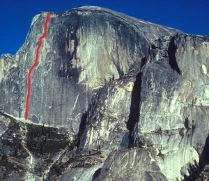
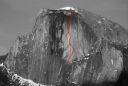
The Regular Northwest Face. Photo: Mark Kroese
Recent Trip Reports
- The Kohala Ditch Trail: 36ish hrs on foot... to and from the headwaters. [5 of 5]
May 31, 2019; 11:57pm
- A Winter Traverse of the California section of the PCT Part 8
May 31, 2019; 11:18pm
- Supertopo,A trip report for posterity
May 31, 2019; 11:00pm
- Balch Fest 2013. Two Days in and Around and On The Flake. The Official Trip Report
May 31, 2019; 10:57pm
- TR: My visit to the Canoe
May 31, 2019; 10:24pm
- Death, Alpine Climbing, The Shield on El Cap
May 31, 2019; 4:07pm
- Andy Nisbet (1953-2019)
May 31, 2019; 2:11pm
- Drama on Baboquivari Peak
May 31, 2019; 1:19pm
- Joffre + The Aemmer Couloir: ski descents come unexpected catharsis [part 2]
May 31, 2019; 7:45am
- Lost To The Sea, by Disaster Master
May 30, 2019; 5:36am
- My Up And Down Life, Disaster Master
May 29, 2019; 11:44pm
- Halibut Hats and Climbers-What Gives?
May 29, 2019; 7:24pm
- G Rubberfat Overhang-First Ascent 1961
May 29, 2019; 12:28pm
- Coonyard Pinnacle 50 Years Later
May 29, 2019; 12:24pm
- Great Pumpkin with Mr Kamps and McClinsky- 1971
May 29, 2019; 12:02pm
- View more trip reports >
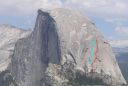
Other Routes on Half Dome
|
| Snake Dike, 5.7 R
Half Dome
Snake Dike follows an amazing feature to one of the most incredible summits in Yosemite. |
|
| Zenith, A4 5.8
Half Dome
The first part of the route is hidden. |
|
| Blondike, 5.11b R
Half Dome
Blondike is the red line and Two Hoofers is the Blue Line. |
|