Trip Report
The Mokelumne Tetons. The What?
|
Friday September 7, 2018 10:24am
|
|
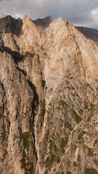
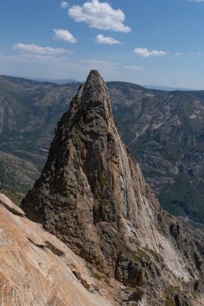
The Mokelumne Tetons do exist. And they are big. Though the good climbing is only in the upper reaches, the drop to the Mokelumne River below is 4,000 feet. They are also remote with an arduous approach and questionable water availability late in the season. Adventurous would be a good way to describe them.
This trip was more than a year in planning. I had flown over the Tetons many times in my small plane as that massive ridge is a visual waypoint when flying over the Sierras from Bishop to my home field at Placerville. Last year I did a closer fly-by and took recon photos. Hmmmm, interesting.
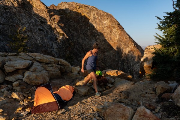
Later last year I went out backpacking with the dogs and checked out the area. Hmmmm, looking pretty good! At that time I didnt know that under the rock I had lunch on was a summit register with the details of 4 or 5 climbs that had been done on the most climbable of Tetons, The Whales Tail. The dogs and I did scout the area and found a couple of springs within ½ mile of the most beautiful campsite youll ever see.
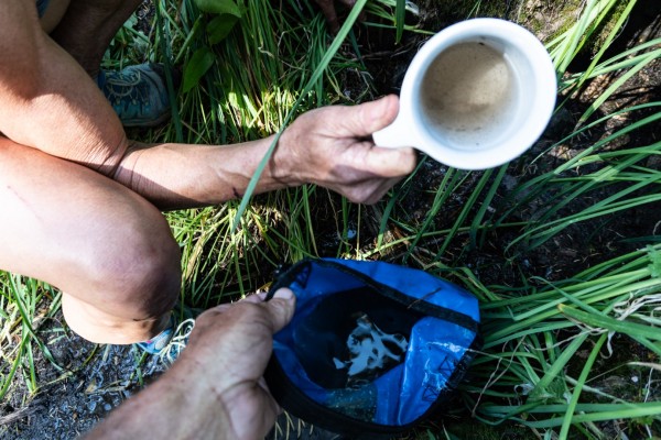
This year we did it. Betsy, myself and Nate made the 9 mile and 2,000 foot gain trek out. Nate came out to check out the area and also helped carry our gear. Thank you Nate. I easily found the first spring location and it was dry! Oh oh, maybe late in the summer isnt a good time for this. The trip hinged on finding water so the ½ mile hike to the next spring was a long one. The spring at first appeared dry, but we found three small pools each holding a few quarts and each would slowly fill back up.
There was no climbing that day as we spent the next few hours filtering water through an increasingly clogged filter until we had about 5 gallons, enough for all of us for the next few days.
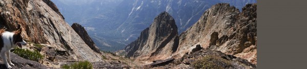
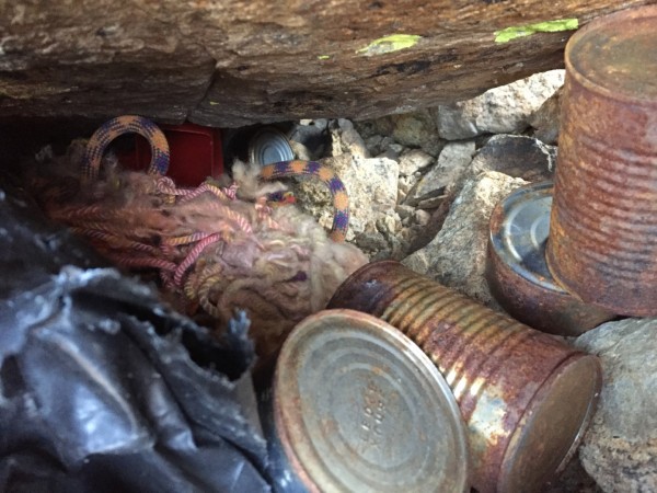
The campsite is truly spectacular and hard to adequately describe. But to the party that stashed two ropes and some canned food tightly wrapped in a tarp under rocks near the campsite your ropes are toast. The cans dont look that appealing either.
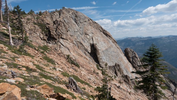
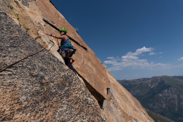
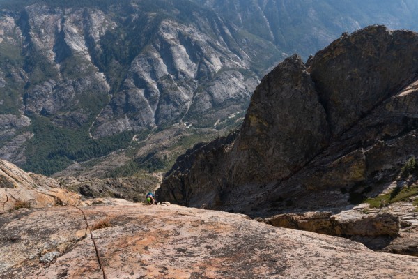
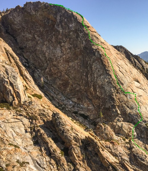
Betsy and I had planned on doing something big on Saturday so we set out to climb a larger Teton than the Whales Tail. This beautiful orange Teton had a tougher approach and a much harder descent so it was very possibly unclimbed. We did the steep downhill approach and got on the toe of the Teton. We were going to traverse around to the face but it looked like we could climb almost straight up from where we were, so we did that at around 5.8. After two pitches we hit a ledge on the face and put in two belay bolts. I climbed up the face, put in a bolt and traversed right, into a depression under a huge flake and there appeared two bolts. Hmmm. Very possibly climbed.
I belayed Betsy up and we discussed our options. My plan was to wrench off the hangers and replace them with our own, then if asked say, Thats strange, we didnt see any other bolts up there. Betsy didnt like that plan. We had come from the left so we decided to go back to the left into the dihedral / crack system and see if that worked. Betsy did a fantastic 5.9+/5.10a traverse to get over there, left-hand drilling and placing two bolts on the way. The second bolt makes the traverse very doable, because if you fall you can just pendulum into the lieback crack, just a little lower than if you made the traverse.
We didnt originally choose that route because we were afraid a sustained hard finger or hand crack would do us in. That didnt happen. There was a vertical chimney section behind a buttress but it had small incut holds for the feet and some nice edges and jugs outside for hands a very fun 5.8. Well, it may have been more fun had I known it was going to stay 5.8 the whole way. I may have even stopped to take a photo which I wish I had done.
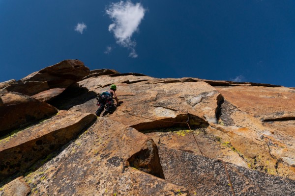
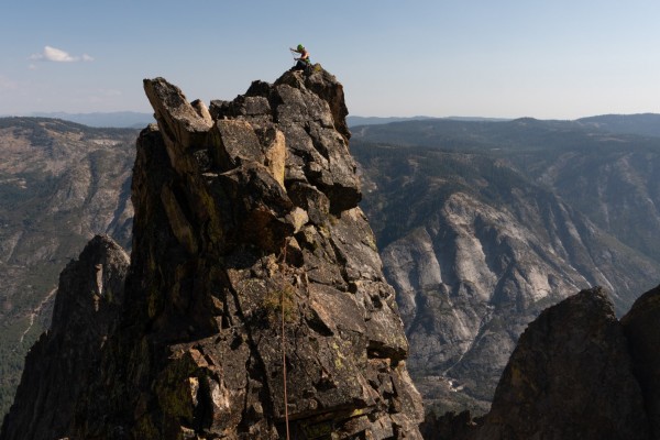
We popped out above the buttress onto the arete with some terrific exposure on the left and a roof above with nice juggy holds, and now with two new bolts one below the roof and one above.
The steepness lets up not long after the roof and soon we were simulclimbing to the summit, where we found a short capped PVC pipe with a damp and hard to read notebook inside with one entry from 2008. Chris McNamara and Todd Offenbacher, a couple of unknown guys from Tahoe. Although it was difficult to tell, it seemed to say The Bee and since neither Chris or Todd can remember, both their route and this particular Teton is now called The Bee.
Todd confirmed their line goes up the face to the right of our line and Chris remembers good rock, but especially remembers the incredible campsite.
From the summit there is a terrific ridge walk reminiscence of Mather Crest and Saber Ridge with a bit of technical downclimbing, until it finally ends with a short rappel. We replaced tattered webbing and a corroded nut with two bolts.
Todd had also put up a compelling climb on Whales Tail (detailed in the summit register) that we intended to do on Monday before the hike out.
But sleeping in, relaxing and having coffee in that awesome campsite before the hike out (you climb about 1,000 feet on the way out too) was even more compelling. Next time.
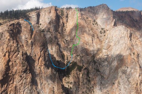
Camp Chasm Arete, 5.9+/5.10a, 6 pitches. Named because you look from camp straight across a chasm at the arete.
The Bee, Chris McNamara and Todd Offenbacher, 2008, 5.10a. The notebook said one pitch of 5.10a and many 5.8/5.9.
 Ney Grant
|
|
About the Author
Ney is a trad climber from Pollock Pines. |
Comments
NutAgain!
Trad climber
https://nutagain.org
|
|
This looks glorious! I went skiing a few times at Bear Valley and Mokolumne looked awesome across the valley.
Around the time I started climbing with ropes, I went on a 5 day snowshoe backpacking trip, aiming for Mokulmne Peak from Silver Lake. We got blizzarded and buried along the way, didn't make it that far, but had a good time. Perhaps my first experience with Type 2 fun - very fond memories now, daintily stepping across thin ice after taking an uncharted short-cut across the lake, stomping out a platform and setting up a tent in blowing white-out, beautiful forests heavily laden with snow in crystal clear mornings, but at the time I recall a lot of being pissed off taking turns dragging a sled or breaking trail through deep powder.
My mentor who taught me how to make toprope anchors and how to rappel, he was all gung-ho to make the objective (probably like I would be within a few years after that). Another guy and I were into morning relaxing, reading, and not really seeing the point of getting hung up on the specific objective. The mismatch in expectations created a lot of friction, which was not good when combined with the physical suffering of the powder slogging. By the end of that trip we didn't talk to each other for a year!
It's funny how much we can change... I think I would have been great climbing partners with this guy for big adventures a few years later, but it took me a while to find my groove and enjoy suffering in the wilderness.
|
|
Gnome Ofthe Diabase
climber
Out Of Bed
|
|
well.
then I stand well, & Happily corrected
As Ive said in the past, When I grow up I want to go to Ney Grant's summer camp.
that bs politics aside,
as I can't do anything about that,
It will go on, it is the back & forth,
the swing of the pendulum.
So still, to the end, I'll stay a fan of what you do.
T U F P!
edit
oh Natetastic?, hows the tutelage coming along?
|
|
NutAgain!
Trad climber
https://nutagain.org
|
|
hornswaggle
I'd never heard (or at least remembered hearing) that word before and now I've heard it twice in two days!
|
|
aldude
climber
Monument Manor
|
|
Like
|
|
Ney Grant
Trad climber
Pollock Pines
|
|
|
Author's Reply
|
Sep 7, 2018 - 11:48am PT
|
The approach in is from the Tanglefoot trailhead, accessed from roads behind Bear River Reservoir. For an out-of-the-way trailhead that probably gets little use the trail is surprisingly good. A good but long day hike is heading up the trail for about 6 miles then heading cross country up Mokelumne Peak, which is kind of a pile of rubble but with great views and a different perspective. Betsy and I went up there late last year and didn't see a soul, but saw lots of bear prints in the snow.
For the Tetons, you take the main trail until a few hundred feet lower than the Tetons on the map, then traverse a few miles over to them cross country. Or at least that is how we did it.
|
|
Fritz
Social climber
Choss Creek, ID
|
|
NEY! Thansk for sharing your strory. I'm very happy that you & your wife keep finding these big climbing adventures in our back yard,
|
|
limpingcrab
Gym climber
Minkler, CA
|
|
Hey, it's cheating if you get to use your plane to scout!
I would like to cheat with you, thanks for sharing.
|
|
Ney Grant
Trad climber
Pollock Pines
|
|
|
Author's Reply
|
Sep 7, 2018 - 02:16pm PT
|
Chris - you approached from below?!? 4,000 feet of loose stuff?
We could see the beautiful blue pools and falls from the Teton. I haven't kayaked the Mokelumne that high, but I think that is the Fantasy Falls section. Looks tough.
|
|
Ezra Ellis
Trad climber
North wet, and Da souf
|
|
This is awesome Ney
Thank you 👍👍🍻
|
|
rick sumner
Trad climber
reno, nevada/ wasilla alaska
|
|
Good work Ney. Your off the established map discoveries/rediscoveries are inspiring.
|
|
mouse from merced
Trad climber
The finger of fate, my friends, is fickle.
|
|
Back in the mid-seventies I explored the back side of Bear Valley along the Moke with Tony, the owner of Tamarack Lodge in BV. We were gone for a week and the wilderness area is truly worth wandering around in.
I had no idea there would be climbing of this quality in the area, but then I did not have the benefit of viewing it from above.
Thanks for your report on such a marvelous adventure, Ney. Hope some day to make your acquaintance.
|
|
Mungeclimber
Trad climber
Nothing creative to say
|
|
Wow! I have a vague recollection of Tuolumne County residents reportedly going out there. Cool to see it get some love!
|
|
looks easy from here
climber
Santa Cruzish
|
|
And this is the reason I have such a hard time getting out of California to climb: so many amazing things you'd have to drive past to get any place else.
A new high Sierra climbing guide is in the works by Vitaliy Musiyenko and others
Sounds like another one to add to my pre-preorder list...
|
|
Natetronn
climber
Sierra Foothills
|
|
Happy I was able to support you two on such an amazing trip! It was well earned and deserved.
|
|
Jerry Dodrill
climber
@dodrillphoto
|
|
Maybe 20 years ago, I hiked out there with Eric Berghorn and Jim Lundeen, dropped in from above and climbed the south ridge of a big tower (Lower Teton?), about eight pitches up to 5.8. We placed no bolts but found a sling on a block about six pitches up. PVC tube with register on top listed Ron Felton and some other folks. We figured it was a third or fourth ascent. If I recall, Jim was in contact with Ron who advised that no bolts had ever been placed but many routes had been done. Corey Rich contacted me a decade later after he was there with Chris and Todd, having seen my summit entry.
This place is pure wildness. Lets keep it that way.
|
|
Ney Grant
Trad climber
Pollock Pines
|
|
|
Author's Reply
|
Sep 9, 2018 - 11:07am PT
|
Yes, that would be the lower Teton. Attached is a photo of mine of that south face. I know there are routes and have a route photo someone emailed me before the trip, but that isn't my photo or my route so I didn't publish it. But that route I saw basically goes straight up the face, hits the south ridge and continues left to the top.
It appears the only way to know what has been climbed on a Teton is to climb it and read about route details in the summit register. In other words, there is a rough guide book, and its public, but you have to climb the Teton first to get it. I've respected that and have not published any other route details except for Chris' and Todd's route, and I asked them before publishing.
I think there are few things climbers should know before going back there, so we don't have bolted climbs over bolted climbs, as almost happened with us. "The Whale's Tale" summit is easily scrambled to, so plan on going there first to see what routes there are on that formation, including bolted routes, number of bolts, etc.
For the Middle Teton call The Bee (there are other "middle Tetons), there appears to be two climbs - ours and Chris/Todds. For the lower Teton I don't know since I haven't been to the summit, and that summit is definitely a full days work to get to. However we all now know the south face has many routes on it, and without bolts.
That lower Teton is fascinating. It appears to have three sides: the lower angle south face and then almost dead vertical west and north faces.
I completely agree with Jerry that it is a wild place that deserves respect.
|
|
Mungeclimber
Trad climber
Nothing creative to say
|
|
Maybe 20 years ago, I hiked out there with Eric Berghorn and Jim Lundeen, dropped in from above and climbed the south ridge of a big tower (Lower Teton?), about eight pitches up to 5.8. We placed no bolts but found a sling on a block about six pitches up. PVC tube with register on top listed Ron Felton and some other folks. We figured it was a third or fourth ascent. If I recall, Jim was in contact with Ron who advised that no bolts had ever been placed but many routes had been done. Corey Rich contacted me a decade later after he was there with Chris and Todd, having seen my summit entry.
This place is pure wildness. Lets keep it that way.
He name names! ;)
|
|
climber bob
Social climber
maine
|
|
|
|
Sep 10, 2018 - 06:32am PT
|
packed in from salt springs resevior with scott rojko @ 1981.we climbed an easy line on the lower teton maybe 5.6. the west face is steep! our climb was on the slabby face to the right.we may have done a rap off a slung flake up high, but down climbed most of the route. I remember the great swimming holes. awesome area, would love to get back there again.
|
|
donini
Trad climber
Ouray, Colorado
|
|
|
|
Sep 10, 2018 - 06:44am PT
|
Thanks for sharing. I wasnt aware of them but they look good!
|
|
Ney Grant
Trad climber
Pollock Pines
|
|
|
Author's Reply
|
Sep 10, 2018 - 08:21am PT
|
That wasn't a very good photo I put up of the northeast face of the lower Teton. Here is a better one.
|
|
Gobie
Trad climber
Northern, Ca.
|
|
|
|
Sep 15, 2018 - 12:03am PT
|
Yep. Those ropes and that dinty moore stew belong to jonny fox and I. I suspect thats how todd found out about the place. Maybe it was the other way around. We went out there in the 90s. We went in from the tanglefoot canyon trailhead. I dont remeber the hike being that bad in comparison to places like tehipite or angel wings. I totally spaced thats were we left my red white and blue rope. Was it out there. We got caught in a massive sierra summer blizzard and had to bail.
Around the same time we had done a new route on the dome across the canyon. We named the dome Freedome and the route The Freedom Train. We hiked into the canyon a couple of times in January and February with tons of gear and camp stuff. We came back in the spring to find it all had been destroyed by a huge bear. It was covered with 100lb boulders but they still got it. Lost a whole rack and a couple of ropes out there as well. Crossed the Moke in freezing water but naked.
That summer we went out to the tetons. I have tried to talk a few people into going back out there. That place is magical. Im right up the road near Kirkwood from June through October every year if you ever want to go back out.
|
|
Ney Grant
Trad climber
Pollock Pines
|
|
|
Author's Reply
|
Sep 16, 2018 - 03:18pm PT
|
Gobie,
I went into the Angel Wings area this summer, so not as far as that, but still a haul. I'm impressed you went in with not only canned Dinty Moore stew but apparently a lot of extra canned Dinty Moore stew.
But I think I know what is going on. You forgot the can opener, didn't you?
So, if you want to, tell us about Freedome and Freedom Trail, not that I'm going to swim naked across the river in the winter to do it. But there is a lot of granite on that side of the river too (obviously, with Cal dome downstream) - I'm curious which one it is.
|
|
chainsaw
Trad climber
CA
|
|
|
|
Sep 16, 2018 - 04:29pm PT
|
Great trip report. Aaron Johnson from MAS climbed some of those Tetons in the 90s. The Great Dihedral he called one route. Chossey 5.8 and no real descent back to the river. I hiked in alone for a day of fishing and got stuck down there. I had bouldered down in with climbing shoes from Bear valley near the grouse trail. The sun went down and I was going to hike out the regular trail. To my remorse, the trail was wiped off the map by a landslide a few years before. I ended up bushwhacking in the dark wearing shorts and sandals. It got cold and wet as night set in. Temp about 30 degrees. Pitch black. I went through a lighter and matches but no fire. It was freezing and moisture was dripping off everything. Out of water. One power bar left.... I drank from a nice puddle in a small gulch. I decided to bivy under a fallen tree where I buried myself in dirt and pine needles for warmth. No headlamp. When the moon came out about 2 am I crawled out through the brush and vertical scree, Bear poo as big as my arm everywhere that was flat. When I got to my truck, I didn't want to four-wheel out so I drove across the ski area and broke the lock off the gate to the highway. For the record, I called the sheriff and told him about the lock. He said he was just glad I got out okay!
|
|
Spider Savage
Mountain climber
The shaggy fringe of Los Angeles
|
|
|
|
Sep 16, 2018 - 08:50pm PT
|
That looks fun! Like a Charlotte Dome of the North.
|
|
Jerry Dodrill
climber
@dodrillphoto
|
|
|
|
Sep 16, 2018 - 11:21pm PT
|
Yep, we climbed that obvious long ridge on Lower and found what must have been climber bob's sling still on the flake. I have a photo of it somewhere.
|
|
|
 |
|
Recent Trip Reports
- The Kohala Ditch Trail: 36ish hrs on foot... to and from the headwaters. [5 of 5]
May 31, 2019; 11:57pm
- A Winter Traverse of the California section of the PCT Part 8
May 31, 2019; 11:18pm
- Supertopo,A trip report for posterity
May 31, 2019; 11:00pm
- Balch Fest 2013. Two Days in and Around and On The Flake. The Official Trip Report
May 31, 2019; 10:57pm
- TR: My visit to the Canoe
May 31, 2019; 10:24pm
- Death, Alpine Climbing, The Shield on El Cap
May 31, 2019; 4:07pm
- Andy Nisbet (1953-2019)
May 31, 2019; 2:11pm
- Drama on Baboquivari Peak
May 31, 2019; 1:19pm
- Joffre + The Aemmer Couloir: ski descents come unexpected catharsis [part 2]
May 31, 2019; 7:45am
- Lost To The Sea, by Disaster Master
May 30, 2019; 5:36am
- My Up And Down Life, Disaster Master
May 29, 2019; 11:44pm
- Halibut Hats and Climbers-What Gives?
May 29, 2019; 7:24pm
- G Rubberfat Overhang-First Ascent 1961
May 29, 2019; 12:28pm
- Coonyard Pinnacle 50 Years Later
May 29, 2019; 12:24pm
- Great Pumpkin with Mr Kamps and McClinsky- 1971
May 29, 2019; 12:02pm
- View more trip reports >
|