Trip Report
Starr King and an improvised FA
Sunday June 16, 2013 3:50am
After seeing Starr King from Tioga Rd. off in the distance and reading about it for years, it was time to go.

My girlfriend, Miss Colleen, wanted to spend time in the mountains and loves to backpack. We talked about it with friends, got the permit and headed out. There were four of us. Joe Berg, Jaywood, myself and Miss Colleen.

The day we hiked in (June 7th) was exceptionally hot (high eighties) as we took off from the Mono Meadows trail head. The forecast was for late afternoon thundershowers but we pressed on. In spite of the thunderstorm threat, we brought our climbing gear anyway hoping to at least take the shorter easy route up the north face if weather permitted. We swam in Illilouette Creek after crossing low water at the trail point on the way for some great relief from the heat.
Then we slogged across the shortcut over the shallow rock covered hill shown in Clint Cummins' overlay approach http://www.supertopo.com/climbing/thread.php?topic_id=1850876&tn=0. The rock was near 90 degrees during the afternoon sun.

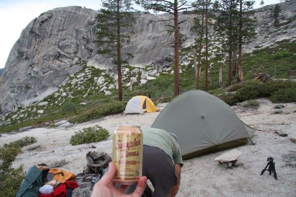
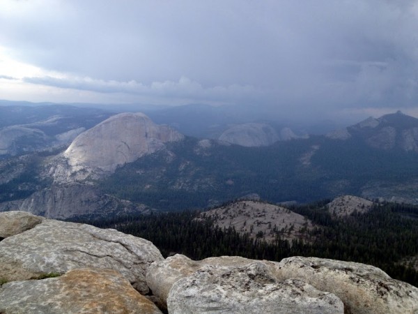
We then took the wash shown to the campsite and set up camp in the late afternoon as thunderclouds passed over Starr King. The views were magnificent.
top left corner top right corner
Camp across from Dome Baez
Credit: Miss Colleen
bottom left corner bottom right corner
top left corner top right corner
Cloud looking west at sunset from campground.
Credit: Miss Colleen
bottom left corner bottom right corner
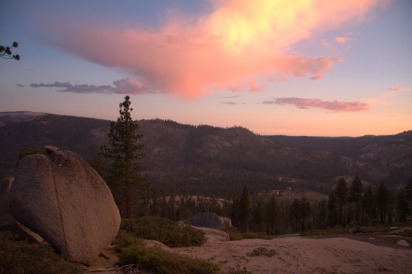
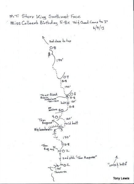
The next morning, the day of Miss Colleen's birthday was cloudless and a bit cooler so the four of us set out to climb a couple of routes on the west and southwest faces respectively. Jaywood and Joe set for the west face and Miss Colleen and I set out for the southwest face. Miss Colleen and I had Clint's overlay of the main face and guessed at where the traverse for the first pitch went (After studying Clint's overlay, it looks like we started much higher as the traverse in the overlay looks like it starts much lower when compared to the bush line we started from in overlay and QITNL's photo's).
photo not found
Missing photo ID#307007
I started out and somehow managed to hit the top of what I believe (after studying the overlay and other thread pictures) is the first pitch anchors of the southwest face or "Tom Rogers" route. The bolts were new SS 3/8ths that Clint and Roger et al. replaced?
top left corner top right corner
At first pitch anchors of the "Tom Rogers" route?
Credit: Miss Colleen
bottom left corner bottom right corner
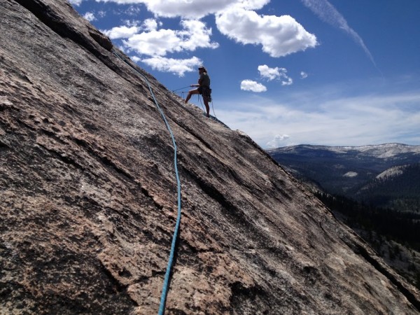
At any rate, we climbed up past two more new bolts to the second pitch anchor of the same route. We looked around and couldn't find any more bolts so I took off up and right to a crack and then traversed back to a point about four fifths of the way along the right side of the big smiling crack/wall to pitch three but I don't think we took the Tom Rogers route there. I think the route was more direct and up from the anchors. Set up a gear anchor and headed out and about 30' past the end of the smile and left the Tom Rogers route behind as I think, after looking at Clint's overlay, that route continues up before the smile ends. I was shooting for a salmon colored streak of large holds,got there and found a bolt about another 30' up from where I traversed so I was about 70' out at that point. The bolt was an old SMC with a square 1/4" nut but was in good shape. That was the last piece of pro I saw for the rest of the climb. Someone had been there but where they went after remains a mystery. Anyone know? Anyway, I climbed a full rope length, found a crack and belayed Miss Colleen up. I had her climb up past me to a large ramp that was comfortable so she wouldn't have to hang at the belay. There was no pro at the ramp and we noticed clouds starting to gather.
top left corner top right corner
No anchor ramp at top of pitch 5.  Notice clouds gathering.
No anchor ramp at top of pitch 5. Notice clouds gathering.
Credit: Miss Colleen
bottom left corner bottom right corner
At this point it would have been hard to bail as we had traversed out and didn't know where or how far the belays were for "Nuts and Bolts" which was supposed to be to the right of us but I couldn't see any gear. So my mission was to find a way up as easily, safely and as quickly as possible because the sky was getting darker. We saw a tree above and aimed for it. The tree is visible in the photo's of the mentioned thread, particularly in QITNL's pictures. The rest of the climb was finding an easy way up through water chutes and some small cracks for belays, but mostly face climbing on good rock. No bolt kit so there are pitches with no pro. The last pitch was finally an easily protected crack. This may converge with the Tom Rogers and Nuts and Bolts routes but it's hard to tell. Third class after the tree.

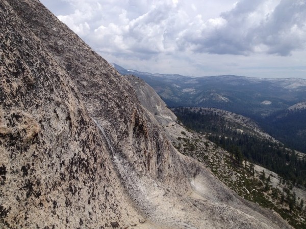
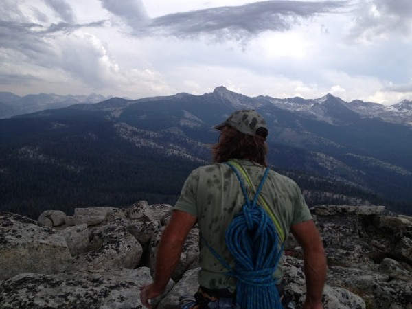
We got to the top and it started to hail but we were lucky. We were on the western edge of the storm and watched it pass over Clouds Rest and on into Tuolumne. The rock was barely dampened and we rapped off safely down to the southeast saddle and climbed up the second dome for a snack and a great view.
top left corner top right corner
Rain and hail over Half Dome and into TM.
Credit: Miss Colleen
bottom left corner bottom right corner
top left corner top right corner
Wet spots on the back from hail.
Credit: Miss Colleen
bottom left corner bottom right corner
So, we apparently climbed on maybe two pitches (second and last?) of the Tom Rogers route. But didn't see a trace, other then the old bolt of a route or gear where we climbed. So I think an unplanned FA went up that day. Here is a topo. If someone went this way, cool. I don't think it will get repeated much if ever and it wasn't intentional but we climbed it none the less. It's on good (maybe great as it is very clean)rock.
top left corner top right corner
Topo of "Miss Colleen's birthday"
Credit: wstmrnclmr
bottom left corner bottom right corner
Miss Colleen was a great partner. Positive and supportive the whole way.


  Trip Report Views: 2,326
wstmrnclmr
About the Author
wstmrnclmr is a trad climber from Bolinas, CA.

Comments
kaholatingtong

Trad climber
The fake McCoy from nevernever land.
  Jun 16, 2013 - 10:30am PT
good times :D
Banquo

climber
Amerricka
  Jun 16, 2013 - 11:35am PT
Bob Steed and I (Dan Merrick) placed the new SS bolts you found when we were there with Clint and Roger. We also used the old bolt you found after exiting the the big ledge (we also found an old ring angle piton at the ledge). As I recall, when we found the old bolt we we decided to depart what seemed to be an existing route and look for something virgin by moving left a bit and then straight up. I no longer recall how protection was above the old bolt but I did take a photo of one of the belays I set.

Bob and I felt the route was 5.6. In the Starr King bolt thread Clint speculates "Illilouette Face 5.5 R, 9?p, aka Tom Rogers SW Face route" If our upper route is new, we call it Illilouette Face. With such a vast face of easy rock, I wouldn't be surprised if people had been there before.

When we placed the bolts on the lower part, we thought we were on a new route but probably weren't. If anybody thinks the bolts should be chopped, that would be fine with me. Clint knows more than I do, perhaps he will chime in. Clint says Tom Rogers did a route on the southwest face and placed one bolt. That may be the old bolt we found.

In this link to his photo, Tom Rogers calls this area the south face and calls it 5.4-5.6.:
http://www.supertopo.com/inc/photo_zoom.php?dpid=PzM_OTw9JSIl

10b4me

Social climber
Lida Junction
  Jun 16, 2013 - 11:59am PT
Looks like great rock
ruppell

climber
  Jun 16, 2013 - 01:45pm PT
It's pretty easy to do an "unplanned" FA on that dome. I did the same thing a few years ago trying to do West Face route. I missed the third pitch traverse back into the corner and kept going straight up. We found one old CMI piton and that was it. Clint's got a variation drawn in purple on the overlay. We kept going straight up from where that variation heads back left and maybe rejoined it again towards the top. I also saw you hiked in from Mono Meadows. Good choice. lol Nice TR.
wstmrnclmr

Social climber
Air B&B Town, USA
Author's Reply  Jun 16, 2013 - 02:26pm PT
Hi Banquo,
You can also see a "p" below the big ledge on the topo as I saw the piton as well. For some reason I decided to head right where you headed left. We ended up climbing more gray granite friction with pockets of the salmon that weren't quite as featured. You can see rock type in photo of ramp. Probably should of stayed left but didn't. The whole area has easier 5th class(the whole of the mountain for that matter as ruppell says) so I was reluctant to call it an FA but I figured since people have been marking where they've gone in the past and figuring it was well away from the lines on the overlay photos,
I figured I might as well call it a route because we did climb it and I think it's a bit harder and in a different direction then the Tom Rogers route ( I think it's directly between the Tom Rogers route and Nuts and Bolts). Also could be a map if anyone gets lost up there again. If I had a bolt kit I would have placed a couple for our own safety. We left a black Metolious in horizontal crack marking our path (was hard for Miss Colleen and the clouds were gathering). It's marked on the topo. Did you end up at the tree?
Warbler: We wanted to get on Walkabout but some key factors kept us off. The first was the weather. We had a morning window on one day and that was it. Monday the clouds rolled in early and we left camp. It was raining on the domes by 1pm.
Also, the forest fires seem to have really changed the landscape. I wanted to ask you what the approach was like when you first climbed it. From our camp directly across from the south face (where Clint writes of the corner system)of Dome Baez, it was near impossible to get to the south face as the Manzanita and Whitethorn were head high or higher (indeed much of the area has the same conditions making travel tough going. Skirting Starr King from the southeast saddle after we climbed it wasn't much fun.). I think one needs to have a few days of good weather to climb both domes with a camp set up in the valley below. If you were really motivated you could possibly do both in a day but Dome Baez I think would be a day alone because the walk off to get around the bushes would take time to find. I think the only way to get to the routes on Dome Baez would be directly up to the walkabout area from the valley. You can't get to the base of the rock from the campsite we were at. I sure would like to get on your route. Tree lines are nice because they are still fairly clear of brush but the whole of the Mono Meadows area has been wiped clean by fire leaving brush to grow.
wstmrnclmr

Social climber
Air B&B Town, USA
Author's Reply  Jun 16, 2013 - 03:55pm PT
Banquo....I think it's OK call to your bolted line a route. Others have done the same,picked a line through easy optional ground and called them routes. That's why I did. After all, I saw your bolts and used them thinking it was an established route. The same could be said of many areas. Often, when I'm on sighting an old slab climb, I often wonder why the FA team picked a certain line where others where available. So routes are nothing more then established roads through terrain possibly having many roads and variations. And they are helpful because on sighting unknown terrain isn't for everyone. I thought the Illilouette Face was an established route but did have a question in my head when Clint put a question mark after the number of pitches. So you did the same. You put up a route. You should map it so others have a known option and can follow safely up a beautiful piece of rock. Your bolts and Clint's overlay is the reason we went there in the first place.
Warbler...I'd be honored to climb it with you. It's a beautiful line.
Sierra Ledge Rat

Mountain climber
Old and Broken Down in Appalachia
  Jun 16, 2013 - 04:08pm PT
Looks like a perfect trip! I'm jealous!

Also nice to see low-impact camping techniques - thanks (:
kennyt

Trad climber
Oregon
  Jun 16, 2013 - 07:27pm PT
Nice work Tony.
Wayne Campbell

climber
  Jun 18, 2013 - 12:22am PT
Nice report..brings back memories of that nice area. Went in there with Tom Rogers and the Devil Dogs many times in the 70's and 80's. And was on the first ascent of the Tom Roger's route, I love that you you guys call it that. We took the longest line up the South Face, and it appeared much harder than it turned out to be. If I remember correctly, Vic Madrid and I were in the lead rope, with Tom and Jan and I think a third climber on a rope behind. Vic and I speeding ahead carried the bolt kit, Leeper hangers with 1/4' buttonhead split shanks with a couple of other types. Tom would yell up occasionally to please put in more bolts! One big belay ledge about mid route was a rounded ramp that angled back down towards the back wall, giving a perfect sitting body belay for the followers! I think we only placed a couple of belay bolts, plus one for pro way up high. It was a great day, very kinetic. Those trips with Tom were so great. I'm curious about the retro bolting on the route. I don't think it's a bad idea to sew it up like Tom wanted. Hey West marin climber, nessage me, I'm in Bo too...
wstmrnclmr

Social climber
Air B&B Town, USA
Author's Reply  Jun 18, 2013 - 02:03am PT
Wayne...It's Tony Lewis. I thought it might be you! It would be great if you could remember the path. It doesn't sound like original bolts were replaced. Two parties have found the bolt up high but the belay bolts seem to be a mystery. We heard about the route here and went to try to find it but two (probably more) parties at least seem not to have found it. It sounds like a great adventure!
Go