Each year since moving to California, Ive gotten together with a group of guys for a snowy climb. Jeremy, Ryan, Chris (aka Knuckles) and I get together for a three day weekend in the Sierra to climb some high point and enjoy each others company free of our jobs and the everyday distractions of the lowlands. The peak over the past two years has been one of my Sierra favorites, Matterhorn Peak, along the northern border of Yosemite. After summiting last year, a new peak was needed for 2010.
Coming into the weekend, the group had our sights set on Shasta, a real, cascade volcano. This would be different for the group--were all more experienced on the Sierra crags that become fun, mixed scrambles when covered in snow. As our weekend approached the weather and snowpack looked questionable. Where to? Lassen? Bear Creek Spire? Whitney? Valley cragging? Mexico?
Whitney has a strict permit system that tends to be booked months in advance. We called the Inyo National Forest ranger station in Lone Pine and yes, no more permits available for Whitney... except four walk-ins. Sure enough, at office closing on Thursday, no one had claimed permits for entry at our trailhead (N. Fork, Lone Pine Creek out of Whitney Portal) and no one had claimed any walk-ins during the previous week. Sitting at my desk at work, Jeremy delivered the news and we decided to make a run for it. Sadly, Chris had also called to bail from the trip because of work.
Thursday night, we blasted out of Berkeley around 8 pm and headed over Sonora Pass to the Eastside. At 3:30am, we rolled into the Alabama Hills outside of Lone Pine, dazed from the drive and hours of blasting Dylan, Bonnie Prince Billy and whatever else suited the mood. By the time we parked our car, threw down our bags and cracked a celebratory beer, faint blue light was creeping higher in the eastern sky and birds began singing from the nooks and crannies of the rocks in the Alabama Hills. I set up the camera and tripod for a few quick shots of our headlamps rustling about in the predawn sage.
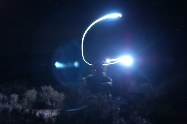 Getting settled in the Alabama Hills after the long drive. Credit: Byrner |
||
Less than three hours later, we were up, reloaded the Jeep and headed back into town to claim our permits. Sure enough, we were the first group in line and easily nabbed our passage into the high country. Sleep deprived, we stopped in at McDonalds for a high calorie breakfast (Sausage biscuit, OJ, burrito, hash browns, egg McMuffin) and then shot up to the trailhead.
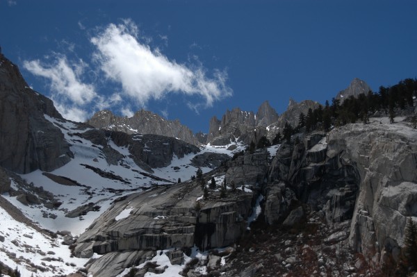
Unlike the crowded summer months, the Portal was pretty calm. A few hikers, some motorcyclists and fishermen wandered about the Whitney Portal store and parking lot. The lines of cars along the road, some vandalized by bears had not yet come. With snow still on the Mt. Whitney Trail, most folks dont attempt the peak. Too bad for them, great for us. The weather felt more like August and the peaks still wore their winter coats.
By 11am, the three of us were on the trail and heading up to our intended camp, Iceberg Lake. The trip starts on the Mt. Whitney Trail, but veers off onto the North Fork of Lone Pine Creek after about a mile. The trail steepens, ascends through a small forest, then into a tight canyon strewn with talus, aspen, alder, scrub and intense green plants and wild flowers hugging the creek.
We crossed the creek, ascended the Ebersbacher Ledges and continued up to Lower Boy Scout Lake where we took a quick break and had some lunch. Up to Lower Boy Scout, the approach felt very classic, eastern Sierra: hot, dusty, dry and snow free. Looking ahead, from the lake, the snow began and we soon entered the alpine environment of snow, sun and granite.
 Credit: Byrner |
||
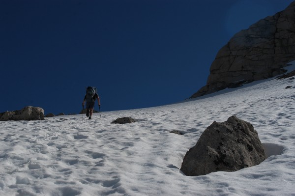
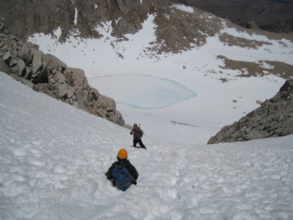
And... we slogged, post-holed and occasionally cursed as we broke through the snow down to our ankles, knees, and occasionally our waists.
 Credit: Byrner |
||
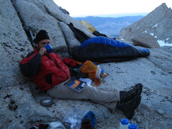
By 5pm, the crew was spent and just a few minutes shy of Iceberg Lake, we found a great camp, perched high on an old moraine that was snow free. It had the view I was looking for--Whitney and its needles-- and it was close enough to the route that getting up early and taking advantage of the hard snow would be easy. We threw our things down, fired up the stove, began melting snow and settled in for the evening in our new home.
Setting up camp and passing the evening in conversation with hot food amidst the changing colors and scenery of the alpine environment is one of my favorite aspects of mountaineering. After a day of sweat, no sleep, and toil up the mountain, I get to relax, reflect and take in the immense beauty from a perspective that few see. Best, I get to take it in with my best friends in between bouts of laughter so strong they end in painful coughs as I gasp for air.
 Credit: Byrner |
||
With a few pulls of Jameson from yee ole whiskey bladder, we retired for the evening.
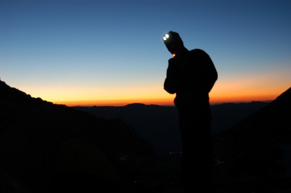
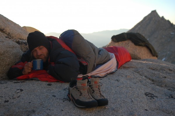
4:30am again and rather than retiring, were waking. Jeremy fired up the stove, made a quick pot of miso, brewed some coffee and we were off as light began to crest the White Mountains to the east.
 Credit: Byrner |
||
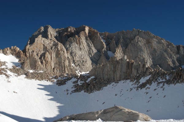
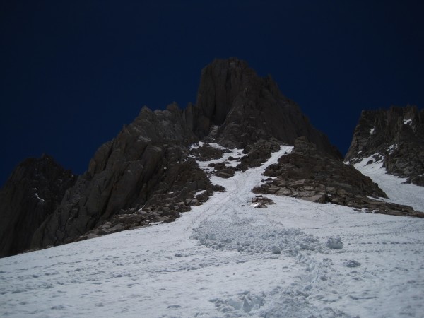
Only a few hundred yards above camp, we encountered the final bench up to Iceberg Lake. In the early morning chill, the snow had re-hardened. We put on our crampons and made quick work of the slope up to lake. From the lake, we had our first clear, up close view of the route.
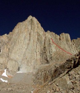
The Mountaineers Route is nothing more than two chutes that ascend the north and east sides of Mt. Whitney. The route was first climbed by John Muir and now people climb it to avoid the crowds and add challenge to the other walk-up routes. In summer, the climb is snow-free and a third class scree party. Spring adds some challenge and fun with snow in most parts of the route, especially high on the route where the climbing steepens.
At Iceberg Lake, we checked in with each other, pumped some water into our bottles and nibbled on a Clif Bar. The weather was perfect, the snow still hard and receptive to crampons; its a go!
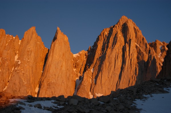 Whitney and Keeler Needle at sunrise from camp. Credit: Byrner |
||
 Mt. Russell from Iceberg Lake. Credit: Byrner |
||
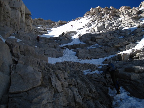
We made quick work of the lower couloir. I would rate it no more than easy second class snow. We climbed with crampons and ice axes, but only for balance and protection should we take a fall. I doubt that on this part of the route, a fall would result in an uncontrolable tumble. Towards the top of the couloir, the snow gave way to rock and scree until the famous notch.
At the notch, the other parties on the route were roping up and one by one, heading up for the final push up to the summit plateau. Jeremy, Ryan and I all felt strong after a quick break for food and some water. We watched one group begin their climb up a crack that was easily avoidable by skirting around and to the right on an exposed snow traverse. I looked ahead and, while it could be a good idea, I still didnt see a need for ropes and well, we didnt have one. I felt comfortable climbing the final bit, so I returned to the spot where Jeremy and Ryan were relaxing to deliver the news. We all agreed that we felt comfortable making the final push without additional protection.
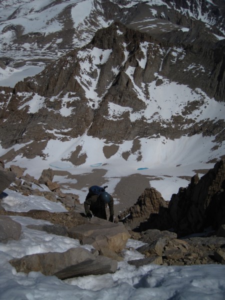
Unfortunately, the notch has been the site of a few fatalities. I didnt quite understand why until I actually saw the spot. The notch is more like a turning point in the route that connects the lower couloir to the final chute that leads to the summit. The final chute is quite steep. A fall here could result in an fatal tumble down hundreds of feet of Whitneys north face. This is typically what happens: people glissade down the upper route, ski down or simply fall on ice and snow and are unable to self-arrest before needing to make the hard right turn at the notch. So, they tumble down over a cliff-band and into oblivion in the Arctic Lakes Basin below.
 Fun mixed terrain on the upper part of the route. Credit: Byrner |
||
I began climbing the last portion of the route and opted for keeping my crampons on throughout the route. The scrambling seemed fairly straight-forward and I would need them for the snow section at the top of the route. The climbing was easy and super fun. I found myself stemming out on my crampons and pulling up on a few handjams and crimps. Jeremy and Ryan followed close behind and we all had a fun time, assiduously working our way up to the snow. By the time we hit snow, it was in nearly perfect condition: cold, hard, and receptive to kick steps and plunges with the ice axes. I found myself in a rhythm of kicking steps and thrusting my ice-axes into the snow. For a few feet, I strapped on my leash and swung my ice tools pick into the firm snow. Soon after entering my rhythm, the snow turned to talus on a nearly flat plateau. I looked left and saw the summit hut, far closer than I had expected it. I called out to Ryan and Jeremy that we were much closer than I thought, they came up, one by one, we dropped our climbing gear and strolled the next hundred meters to the summit oficial. Success!
 Jeremy coming up through the upper portion of the Mountaineers Route. Credit: Byrner |
||
After lunch on the summit and a whole round of photos of the area and of us on the roof of the lower 48, we began the decent back down the Mountaineers Route. We downclimbed the route with no difficulties, de-cramponing midway through the upper portion of the route. Many blocks and horns were previously slung with cord and webbing as rappel anchors for those parties that used ropes. The parties ahead of us were lowering off of these anchors. While downclimbing the route and watching people lowering themselves, we agreed that it might just be safer to focus on downclimbing and footwork rather than weighting rapp anchors that arent necessary and could dislodge a block.
After the notch, we three descended the scree and rocks of the upper portion of the couloir and then... began glissading for hundreds and hundreds of feet down to Iceberg Lake. One by one, we tossed ourselves onto the snow and slid down, bumping and screaming in delight down to the end of the couloir. The snow was soft and very warm with a lot of free water. As we approached Iceberg Lake, a party above us triggered a point release avalanche that ran out next to us. The coolest part is that it terminated with the creation of a massive roller ball that ended up carving a massive trench nearly 4 feet deep in the snow.
 Glissading back to Iceberg Lake. Credit: Byrner |
||
 Point release avalanche. Credit: Byrner |
||
We spent the next hour lounging on a large, table like rock near Iceberg Lake, staring at the faces of Whitney, Keeler and Day Needles and envisioning ourselves high on the routes later in the summer. Soon we descended back to camp, dropped our packs and enjoyed a long afternoon on our cozy rocks. The light softened, the shadows lengthened and finally the sun dipped behind Whitney for our last night. Exhausted, we barely made it through dinner before succumbing to sleep.
Sunday, we awoke to brilliant alpenglow, brewed some coffee, broke camp and headed back to Whitney Portal.
 Credit: Byrner |
||
By 11am we were lounging on our crashpad and sipping the delicious malty refreshment of Stone Pale Ales. Life is good in the mountains.
Check out more trip reports and photography on my blog: http://tiedin.wordpress.com/