Trip Report
Seven Gables Trip Report on 3 Climbs
Thursday August 7, 2008 3:33pm
I have ignored the western approach to the High Sierra. The eastern approach is just more dramatic and easy for most peaks. When I got an invite to climb Seven Gables, i got my first glimpse of the high western slopes.

The initial drive isn't that exciting. Mammoth and Lee Vining on the East side have dramatic views. Madera and Prather on the west side have Pizza Factory's "we toss em, they're awesome!". But once you start gaining elevation up "the famous four lane" the drive gets cool fast. The last hour of driving to the Vermillion Lakes resort is staggering: a skinny road with big drop offs and views that winds through blasted granite.


Dan Duane, lead journalist, is smart. So smart he hired mules to carry our gear while we hiked with day packs. I highly recommend this if you can get someone else to pay the $700 for it. Jimmy Chin was team photographer and Ivo Ninov was team story teller. Everyone was a pro at their job. Including me: team dork as I was the only one to bring a giant sun hat, trekking poles and a solar panel so i could listen to books on tape the whole time.

We spent the first night at Vermillion Valley Resort. Great spot and their web site has great directions for how to get there: http://edisonlake.com/site/content/blogcategory/29/54/

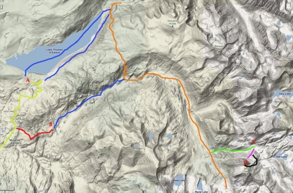
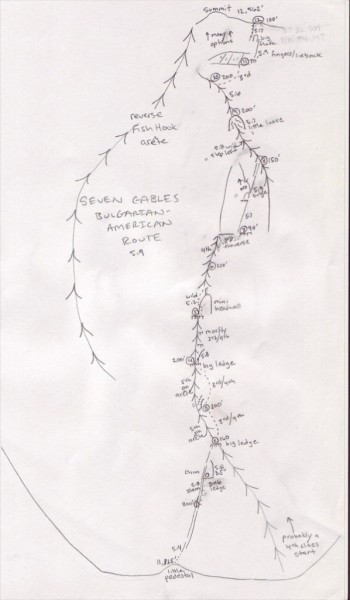
OK, its business time. Direct your attention to the map below.

top left corner top right corner
bottom left corner bottom right corner

The puke green line is the road in. "A" is the Vermillion Valley Resort. The blue lines are the 3 difference ways to start the approach. The orange line is Pacific Crest Trail/John Muir Trail.

There are three ways to start the approach:

1) The top blue line is the boat taxi way. The lake was pathetically low meaning the boat taxi ride would not have been scenic or cut that much time off. This option is probably cool if the lake is high.

2) Walk along the lake. This option is best if you don't want to pay for the boat taxi and you cant do option 3 below.

3) this is the way we took because the packers recommended it and it involves the least amount of elevation gain and loss. The red line on the map is a 4 x 4 section that was a great adventure to drive. With all-wheel drive and 7 inches of clearance of my 97 Subaru Outback i barely made it. In the future the road could better or it could be worse (high clearance 4 x 4 mandatory). There are water washed roads above a good drop off to a valley below. In some sections you drive on giant granite slabs and have to look carefully for where the road picks up again. Like the Slick Rock trail in Moab but of granite. Too fun.

B on the map is the parking area after the road described above. here there is a great lake to swim in.

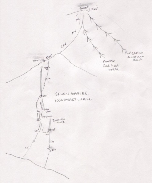
The junction of the orange line and the green line is the farthest the pack animals will go. From there you climb about 1000 feet up a thin trail to our camping area marked by C on the map. The purple line is the approach up to the base and D is the lower summit. The summit that all the cool climbing routes go to. The black line is the descent.

Next slide please.

top left corner top right corner
bottom left corner bottom right corner

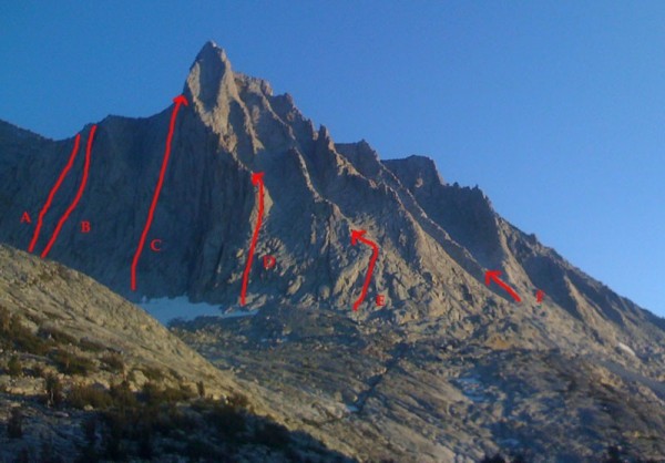
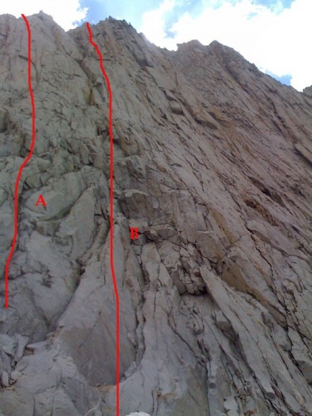
First off, this is not the main summit of the Seven Gables. Most of the cool routes go to this lower summit. And I assume the name Seven Gables comes from the 7 distinct gables/aretes you see in this photo.

Here is my best guess at the routes in this photo

A - Probably the route Galen Rowell did 88. 5 pitches 5.9
B - Our attempt to repeat the Rowell Route. 5 pitches, 5.10a
C - Probably the route Vern Clevenger did
D - A reverse Fish Hook arete that has probably been climbed twice. or maybe never.
E - A cool route we did. If its a first ascent we are calling it the Bulgarian-American Route
F - A route I soloed, 5.6. Probably not a first ascent.

As you can tell from above, solid first ascent info is hard to come by. Dan Duane did a lot of research about the peak and found that just about everything is in question. A few past guidebook authors said that they had drawn in the wrong lines on the photos in the books. So its hard to know exactly who did what when, but i can tell you about the three routes we climbed:

First off, we did route E on the photo. 5.9, 12 pitches with 1400 feet of elevation gain and about 2000 feet of climbing. This was like Temple Crag with golden granite. Exposed ridges with mostly easy climbing with the occassional 5.9 move. You can simul climb a lot of the route if you want.


top left corner top right corner
bottom left corner bottom right corner
Here Dan Duane on pitch 7.


Looking down the route from the summit. I am not sure if the arete/gable to the left has been climbed
top left corner top right corner
bottom left corner bottom right corner


Here is a topo for our route. If its new, we are calling it Bulgarian-American route because Ivo is from Bulgaria and it sounded cool after a bottle of wine at camp one night. Rack for the route: 2 ea cams up to 2.5". 1 3.5" cam. stoppers.

top left corner top right corner
bottom left corner bottom right corner


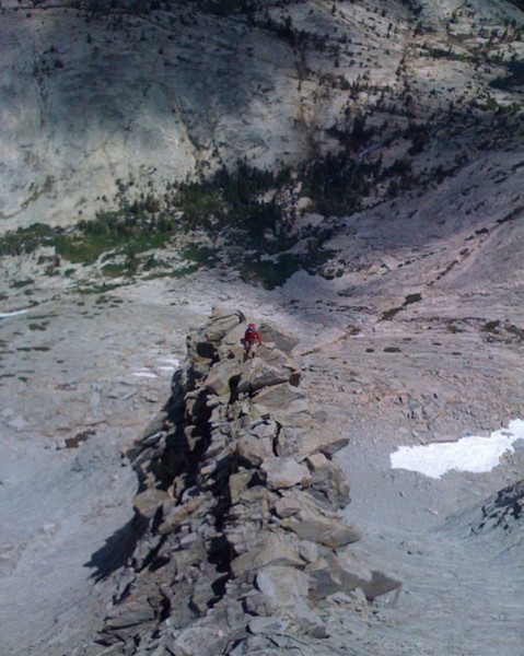
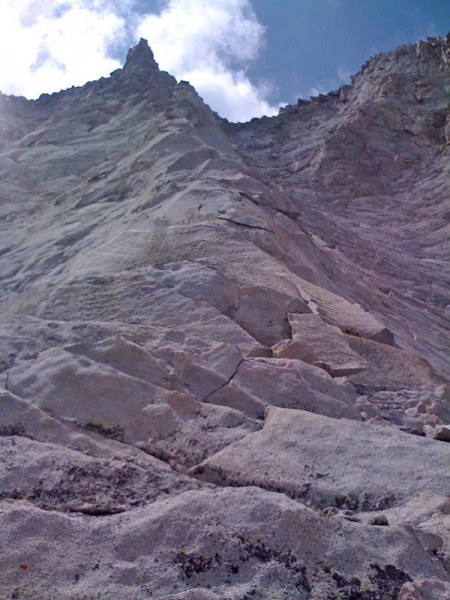
The next day everyone else wanted to chill. So I soloed the easiest and clean looking gable (Route F in the photo above). This route was really fun. Mostly 4th class on clean golden granite with the occasional exposed 5.6 section. I was a little nervous about the headwall pinnacle you can see at the top of the photo below. But it had a bomber 5.6 crack right through it.

top left corner top right corner
bottom left corner bottom right corner

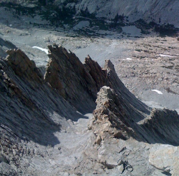
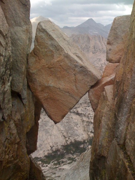
And a cool chockstone just below the summit.
top left corner top right corner
bottom left corner bottom right corner

I found bail slings on the lower part of the route. So not sure if anybody had ever climbed this before. Overall the rock was great. Sorta similar to West Ridge of Conness in length and difficulty.

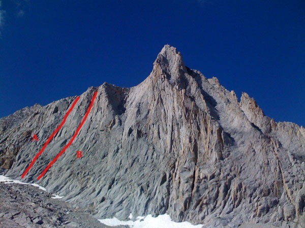
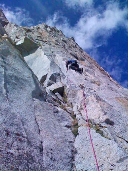
The next day we tried to repeat the Rowell Route from 1988. Apparently this is incorrectly marked in guidebooks. Here is the description from the 1989 AAJ:

"Seven Gables, 13,075 feet, Second Gable, Chimney Route. Letemendia and I asceneded this 1400-foot 5.9 route on the longest face up the northeast wall, while Dick Duane and Kevin Worral did the Right Wall Route (5.9). Both on August 18."

The route we did (route B on the photos below) is probably not what either team did. They were probably to the left. (Route A in the photos below). But none of us knows for sure.

top left corner top right corner
bottom left corner bottom right corner

top left corner top right corner
bottom left corner bottom right corner

The route we did was 5 pitches and had a definite 5.10a section that was not quite runout. Here is Ivo leading that crux section.

top left corner top right corner
bottom left corner bottom right corner

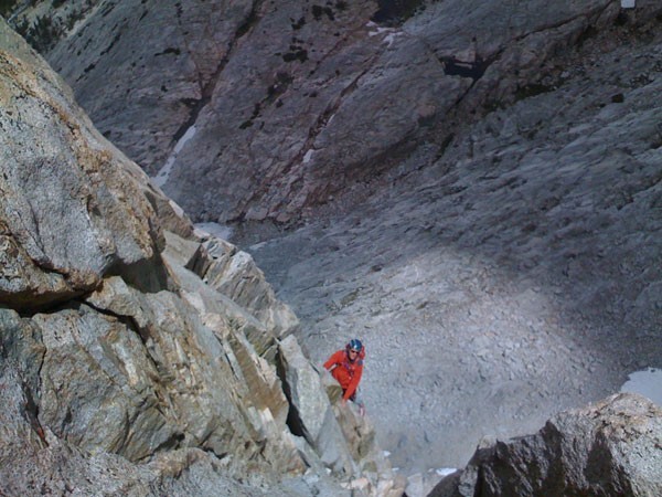
and here is Dan near the top.

top left corner top right corner
bottom left corner bottom right corner

And here is a topo for the route we did. Rack: 2 ea cams up to 2.5". stoppers.

top left corner top right corner
bottom left corner bottom right corner


I don't know if i would recommend routes on this wall. The rock was fine but if you make the journey to come in here I would recommend a route that goes all the way to the summit (Routes C,D, and E in the photo up top)

Overall this is a great spot to climb. Its like Temple Crag but not as big and with better rock. Because its 17 miles in, you can't realistically do any of the routes car to car in a day. If you have 4 days and the money for packers, this this is an awesome place to climb and hang out.

  Trip Report Views: 3,722
Chris McNamara
About the Author
Climbing Magazine once computed that three percent of Chris McNamara’s life on earth has been spent on the face of El Capitan—an accomplishment that has left friends and family pondering Chris’ sanity. He’s climbed El Capitan over 70 times and holds nine big wall speed climbing records. In 1998 Chris did the first Girdle Traverse of El Capitan, an epic 75-pitch route that begs the question, “Why?”

Outside Magazine has called Chris one of “the world’s finest aid climbers.” He’s the winner of the 1999 Bates Award from the American Alpine Club and founder of the American Safe Climbing Association, a nonprofit group that has replaced over 5000 dangerous anchor bolts. He is a graduate of UC Berkeley and serves on the board of the ASCA, and Rowell Legacy Committee. He has a rarely updated adventure journal, maintains BASEjumpingmovies.com, and also runs a Lake Tahoe home rental business.

Comments
L

climber
Just livin' the dream
  Aug 7, 2008 - 03:44pm PT
Wow Chris! For the guy who labels himself the dork of the team, you produced a fab TR!

Your iPhone photos were stellar--Ivo on the crux pitch especially.

And only $700 to rent mules, huh? Pocket change....


Thanks for posting this.
Chris McNamara

SuperTopo staff member
Author's Reply  Aug 7, 2008 - 03:48pm PT
oops. I should have said none of these are Jimmy Photos. These are all from my iPhone.
drgonzo

Trad climber
east bay, CA
  Aug 7, 2008 - 03:52pm PT
Thanks for the TR.

Did you consider going in a Florence Lake and hitting the cutoff for the JMT by Muir Trail Ranch, and popping over Selden Pass to get there?

I'm not sure if that'd be shorter but it'd be easier on your vehicle.

L

climber
Just livin' the dream
  Aug 7, 2008 - 03:53pm PT
iPhone shots? Really? Dang...
rhyang

climber
SJC
  Aug 7, 2008 - 04:36pm PT
Thanks for the alpine stoke :)
Chris McNamara

SuperTopo staff member
Author's Reply  Aug 7, 2008 - 04:36pm PT
Yeah, i was a walking advert for the iPhone. I listened to books on tape, made phone calls and responded to emails on the summit (yes there was cell reception!) and took some photos.

I even tried to figure out if these were new routes while were climbing them.... but nobody replied to my post:

http://www.supertopo.com/climbing/thread.html?topic_id=638373

By the way, the brunton solar panels rule! This one kept my phone charged the whole time.

http://www.amazon.com/Brunton-SOLARIS-i6-Foldable-Charger/dp/B000P696L8/ref=sr_1_7?ie=UTF8&s=hi&qid=1218141329&sr=8-7
Mighty Hiker

climber
Outside the Asylum
  Aug 7, 2008 - 05:13pm PT
Thanks, Chris!

What is the scale involved, e.g. the length of Lake Edison?
Chris McNamara

SuperTopo staff member
Author's Reply  Aug 7, 2008 - 05:35pm PT
hmmm.. not sure about scale. google earth says Lake Edison is 3.7 miles long. the overall approach we took is 17 miles
tallguy

Trad climber
tacoma
  Aug 7, 2008 - 06:51pm PT
Chris,

A friend and I did the standard route last september (closer to the clevenger route, really right between your C and D lines, but your photo is dark and hard to tell), and when we summitted, the summit register had a great photo of 7 gables with numberous routes drawn on it. Did you find this in the summit register can? From that photo, it looks like all of the buttresses on climbers right of the main wall had been climbed previously and were named. There were also two named routes near the clevenger route, but nothing that looked far enough over to be the Rowell route indicated in your photos. I think you might need to hike back in and search for that topo to be sure, its the only place I have ever seen such info of routes on that formation. Hiking in from the east is an ass kicker, less mileage but more elevation change.
Mike Bolte

Trad climber
Planet Earth
  Aug 7, 2008 - 07:17pm PT
excellent TR and adventure! thanks!
Captain...or Skully

climber
Boise, ID
  Aug 7, 2008 - 07:22pm PT
Good shtuff, Mr. Mac.....Quite.
John Vawter

Social climber
San Diego
  Aug 7, 2008 - 08:01pm PT
Here's an old TR I pulled off wreck.climbing from Craig Clarence. I'll leave it to you guys to sort out which line he an Risa did.

Seven Gables (North Peak) Direct East Face: IV 5.9
September 21-23, 2000
Risa Hvelasquez and Craig Clarence (writer)

I wanted to finish the High Sierra climbing season with a remote and obscure route, and Seven Gables seemed to fit the bill. Double digit approach mileage coupled with two cross country passes over 12,300 feet guaranteed a long approach day and no company on the route. The plan was to climb the North Buttress of Merriam Peak on the way out, as the approach goes right under this impressive face. It turned out that trying to do both routes in 3 days was too much - we'll have to go back for Merriam.

I'd never met Risa but we had spoken a few times and she seemed up for an alpine route. I cleverly forgot to bring a map of the Seven Gables area so she was unable to note the long mileage and veto the idea. Seven hours into the approach from Pine Creek to Vee Lake in the Bear Creek drainage I was wishing she had. It took almost 10 hours from the car to make it to camp that night. We barely got diner cooked and eaten before darkness and exhaustion drove us into our bags.

The crux of this route (besides the approach) was determining which peak to climb. Looking at Secor (2nd Edition) after I got back, I noticed he had drawn a line on the photograph of the south peak and labeled it the "Direct East Face." Not only was this not the route we climbed, it was not even on the same peak!

A note to John Moynier (co-author of the "100 Sierra Classics" book) quickly set things straight. The line drawn on the south peak and labeled "Direct East Face" in Secor's book is incorrect. The correct route in on the north peak, which is the prominent pyramid-shaped mountain on the right side of the picture in the "100 Sierra Classics" book. This means that the "Chimney Route" drawn into Secor's picture is also incorrect.

Moynier is a bit vague in his written description of this route, but I'd guess that the route we took more or less followed the first ascent line. Beginning at the middle of the north face, we headed up a series of corners and discontinuous cracks. About half way up the face is a prominent clean-looking dihedral which ends at the crest of the arete - we started underneath this dihedral and climbed through it. The dihedral itself turned out to be 40 feet of classic stemming
and jamming over clean rock.

From the top of the dihedral the route follows the ever-steepening knife-edge arete to the summit of the north peak. I felt the final pitch was the crux, probably a bit harder than 5.9. Actually, the climbing on all 8 pitches was sustained and interesting. We saw no signs that anyone had ever been on the route, which I've found to be a rarity for climbs listed in the "100 Sierra Classics." Traversing from the north peak summit to the notch, we dropped our packs and scrambled up to the high point on the south summit. Legions of boy scouts/outward bounders/sierra clubbers had filled the register - kind of surprising considering the peak's relative remoteness.

The route took six hours, but by the time we got back to camp our original plans of packing up and moving back towards Merriam Peak were forgotten. We did a slow retreat the next morning."

The clean rock on this route, it's sustained nature, and the remote setting make this one of the most challenging and satisfying climbs I've done in the Sierra.

-Craig Clarence


Nefarius

Big Wall climber
Fresno
  Aug 7, 2008 - 08:07pm PT
Not to slam ur iPhone or pic skillz, C, but I think it was pretty obvious those weren't Jimmy Chin shots. :)

Fun stuff! Where was this slab driving on the way to Vermillion? It's an actual road all the way in... Fun drive though!

Thanks for the cool TR!

edit: nevermind.. .looked at the map this time. :)
Steve Grossman

Trad climber
Seattle, WA
  Aug 8, 2008 - 01:51am PT
Great TR Chris! More fun with Sierra blocks!
Risk

Mountain climber
Marooned, 855 miles from Tuolumne Meadows
  Aug 8, 2008 - 01:52am PT
Chris,

Thanks for the great TR bringing back memories of this very fine country. That approach, from Bear Diversion Dam Road, is one of my favorite trailheads. I took many a ramble from there with legendary fishing success and incredible alpine solitude. The road you say is rough? My 66'VW Camper pulled it off once! Really! Thanks for the iPhone shots, if that's what they are.
Chris McNamara

SuperTopo staff member
Author's Reply  Aug 8, 2008 - 11:08am PT
Thanks for all the info.

KW, yes, Dan Duane is Dick Duane's son. And the main goal of the trip was to repeat the route(s) you/Dick/Galen/Seb did.

Sounds like just about every main line on the peak has been climbed... just nobody exactly knows by who when. We can all think we did first ascents!

Except, it sounds pretty clear that the routes we did were not first. Oh well. It was a great mountain and location. I'll have to get Ivo to climb another new route with me so we can name it the Bulgarian American Direct or something

And just to clear up above "the slick rock on granite" driving section was not to get to Vermillion. it was the three miles marked by the red line on the map for the approach option we took.
tallguy

Trad climber
tacoma
  Aug 8, 2008 - 01:26pm PT
Chris,

I think your B route has the potential to be a FA, I don't recall seeing any routes over that far on the topo (though it was awhile ago). I also think there still may be some proud lines to do there or near there. For example, just left of the standard route (described by J. Vawter, with the clean dihedral ending on the arete), there looks to be a nice series of corners and cracks leading up to a prominent face high on the arete. Proud line, biggest area of the face, looks 5.10ish, and not written into the summit topo. Merriam right side has some proud hard splitters that may be FAs too if you can figure out how to get to them.
MZiebell

Social climber
Prescott, AZ
  Aug 8, 2008 - 03:31pm PT
Great TR Chris - need to plan a trip in that direction....
snake

Mountain climber
sebastopol
  Aug 16, 2008 - 03:58pm PT
The Bulgarian-American route on 7 Gables (route E on the photo) was climbed in September 1999 by Stuart Polack and Walt Vennum who named it "The Golden Thread Arete." There is an account of this climb on pages 182-183 of the 2000 American Alpine Journal. Sincerely, Walt Vennum
Crimpergirl

Sport climber
Boulder, Colorado!
  Aug 16, 2008 - 04:21pm PT
Excellent TR. Sorry I missed the original post linked above. I especially liked the "next slide please". Cracked me up!
Flashlight

climber
  Aug 16, 2008 - 04:22pm PT
I recommend "B". There is good camping at the road end at Bear Diversion Dam. Gradual 17 mile hike from there with only one 1/2 mile semi-steep section about 2 miles in. Did this to the base of Seven Gables in one day with full packs and it wasn't too bad. Hiking along Bear Creek the whole way so water was never scarce. You could still have the mules carry your stuff in and just hike up from Bear Diversion. The road to Bear Diversion is negotiable in 2 wheel drive but rough in sections. Two wheel drives are probably responsible for the washboard sections due to spinning tires however.

My favorite mountain in the Sierra. Thanks for the TR Chris.


GDavis

Social climber
SOL CAL
  Aug 16, 2008 - 06:37pm PT
Looks like a good place to bag some super long routes. Always catches my eye.
nb3000

Social climber
Bay Area
  Aug 19, 2008 - 01:00am PT
bump
Chris McNamara

SuperTopo staff member
Author's Reply  Aug 16, 2009 - 12:48pm PT
There is a story about our climb by Dan Duane in the latest version of Men's Journal. They put the excerpt below on their web site but if you want to read the whole thing you have to buy the magazine:

From Daniel Duane’s My Father’s Mountain:
http://www.mensjournal.com/in-the-september-issue-style-design

The 13,075-foot mountain towers over California’s central Sierra Nevada range, and I went up there to replicate the greatest climb of my father’s life. Back in 1988, when he was 49, he scaled one of the sheer rock faces on Seven Gables as part of an expedition with his friend Galen Rowell, a world-class high-altitude climber and adventure photographer. I had been invited along, but I was a novice at the time, only 20 years old, and felt intimidated, so I declined. Afterward Rowell published a report in the American Alpine Journal claiming several first ascents on major peaks, and he included a photo of my father high on Seven Gables, leaning away from the white cliff as he scouted the route above. For me, this was like being a novice surfer, hairing out of a Hawaii trip with your dad and his pro-surfer buddy, and then having Surfer magazine publish a shot of your pops getting barreled at Pipeline. In other words, it was hell, but awesome, too. Rowell gave my father an autographed color print of that image, and it hung framed in our family dining room, torturing me with self-reproach but also giving me the determination to become a better climber and maybe even a professional adventurer like Rowell.

Last year, I finally planned my own Seven Gables trip. I’d long since quit climbing, but this felt like unfinished business….

I had no interest in doing just any route on Seven Gables; I hoped to replicate Rowell’s photo of my father, but with me in his place, at the exact same spot on the mountain. That meant we had to sit there in the cold air, sip scotch, and hash out every nuance of our memories about the two men, from Rowell’s photographic motivations to my father’s actual climbing ability, to speculate about which route they would have picked. For me that meant unearthing and confronting some complicated feelings about both men, and myself.
10b4me

Social climber
Lida Junction
  Mar 12, 2014 - 09:58pm PT
Bump
Larry Nelson

Social climber
  Jun 2, 2016 - 11:53pm PT
Bump for great climbing content
nah000

climber
now/here
  Jun 2, 2016 - 11:59pm PT
fUcking awesome!

the dude, as always, abides...
Go