 Credit: MooseTracks |
||
I had worn mountaineering boots for this trek, knowing the upper ridges would have at least some snow, probably requiring crampons. I had played with the idea of carrying my boots and wearing trail runners for the lower 6000ft of the ridge, but when the pack alone weighed in at 22#, I simply decided to count on my legs to have the strength to lift my booted feet for 10,000 vertical feet.
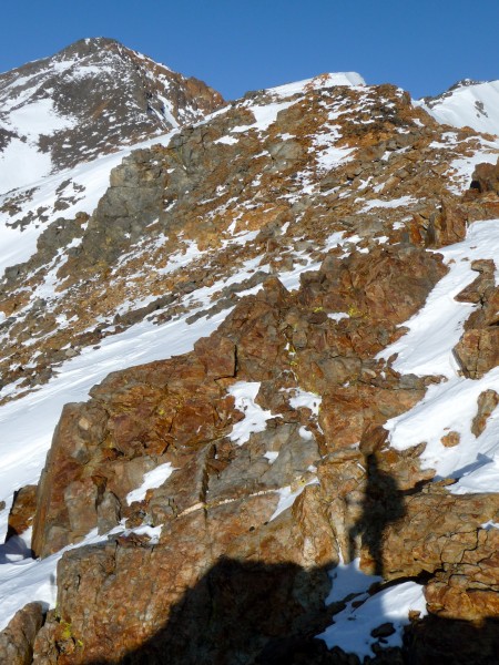
Early morning brought me to 10K, and the snow line, still thin in places near the trees but easily broken if I wandered too far onto north slopes. The sun finally crested the Whites, warming the red and yellow fractured rock along the ridge. I popped up onto the 11K ridge, undulating east towards the saddle, and revealing The Beast. About 1500 feet of blocky scralus, with intermittent snow, stood regally before me, daring me to even try. The crusted and windblown snow coated the saddle and the first 500 ft, allowing for solid foot plants on a steep slope. As the sun warmed the snow tongue, icy fingers gave way to hardened slicks, and I was forced onto the crumbling slope. A few steps had me pondering the entire concept of angle of repose as I sent a few chunks flying to the drainage far below.
It was here that I experienced my first doubts of the day. My legs werent particularly tired, but breathing came hard with effort, both from steps and tenuous balance on shifting rock. Between steps, I glared at the top of the slope, gritting my teeth and hissing, You will NOT GIVE UP. I filled the spaces with grunts and self-encouragement, allowing breaks every 50 steps, every 32, every 20; picking apart the ridge step by step, inch by inch. I laughed out loud upon reaching the edge of the lower angle ridge, spotting the summit hut for the first time that day. I knew it was still hours away, but there was something about seeing my goal, even somewhat within reach, that brightened my spirits like the sun twinkling on the snow.
I was rewarded with perfect cramponing snow along the ridge: styrofoam and solid, even bearing my weight as I glanced down thousands of feet through chutes into Millner Canyon. The blocks increased in size as I gained the Class 3 section of the ridge, the snow narrowing the top edge to a knife-edge and forcing me onto the north side to scramble and pray I didnt pull anything down on my head. Beyond the scrambling, I finally removed my crampons to start trudging up the scralus once again, seeming to bite, scratch, and claw my way to the top. With one final obstacle, bypassed on the north by some easy downclimbing (the eastern face chimney dropped directly onto a wind-loaded south face chute that dropped for god-knows how many feet), I clambered up the last rocks to meet the summit hut face to face.
SEND!!!! I screamed across the mountaintop. After the echo faded, all that was left was the blue of the sky, the sun shining bright on my face, a breezes caress. My smile broadened as I stretched both arms high overhead.
The descent became a race with the sun, which was winning. I had forgotten my watch at home, but checking my GPS revealed a 3:30pm summit time. I wolfed some treats, guzzled half a liter of Gatorade, and started to tear across the mountain as fast as the slope and scralus and Class 3 would allow. I wanted to get to the bottom of The Beast by sundown, knowing I could pick my way down the ridge from there. With an almost full moon rising behind my left shoulder, the ridge burst into flame in the sunset, my steps on the lower snow slope shadowed in the low light angle. I traversed the south face of the ridge, hoping the shaded slopes would have firmed up to cross with ease.
No such luck: let the postholing begin.
One thousand vertical feet of crusted sugar stood between me and the lower scralus slope, the moon casting long shadows across the snow. I valiantly stabbed poles as deep as I could, trying to find solid ground for leverage and praying my shoulder wouldnt be too angry in the morning. I dove for trees, breathing heavily and smelling their wet needles cradled between the roots as I rested. Somewhere along the way in the swim, my crampons, hanging off my ice axe, had been snagged, perhaps while crawling through a thatch of mountain mahogany. With a tired shrug and a sad look back, I relinquished my sacrifice to the mountain. GPS in hand and zoomed in, I wove through the scrub to emerge on the lower slope at last, free of snow and blessedly dry.
I pulled out my cell phone, begging for just enough signal and charge to get a message to my friend Brent, who was up for the weekend, presumably crashed at the Moose Lodge. I tried to sound upbeat and energetic in my message as I looked out into the darkness of the Valley. Bishops lights twinkled to the southwest, and for a few moments, I shut off my lamp to breathe in the night. I wondered to myself about spending the night, knowing in the stillness and relative warmth that I would be just fine. But I also knew the scralus was not the place to hang out, and the duff of the trees below would suffice if needed.
I dont know if it was the Gatorade, or the thought of pulling off the day hike that lit my fires. My big boots protected my feet and ankles from the scralus as I careened down the slope into the trees, poles searching for points of contact and balance. My stride lengthened, and I knew the beer-dar had engaged, my little dome of light bouncing along as I ducked and wove through the pines.
Just before I hit open ground, I scanned the blackness below to the west, and saw it pierced by nothing less than headlights! The truck crept along Millner Creek road, disappearing behind the ridge to my south, then re-emerging headed back west. I continued steadily down, fantasizing about cold beer and hot pizza, wondering about the truck I had seen. Long strides and shifting sand finally brought me back to the jeep road, my quads screaming at the descent pace. On the lower road, I cowered a bit at the headlights cresting the hill, knowing I was vulnerable, exhausted, and in the middle of nowhere, almost two miles from the TOF.
Fear turned to exhilaration as Brent smiled out his drivers window at me. But he knew what to say:
Youre going to finish this, arent you.
Youre damn right I am.
A few postscripts:
Stacy (biletchick) and Curtis were in town for the weekend also, and, along with Brent, we grabbed breakfast at the Petite Pantry. I thought Id be hungry, but I only picked at the food. After a short snowshoe up Rock Creek, then a hike into the Happy Boulders with Brent to move the pad around for him, I collapsed into bed and the deepest sleep Ive had in months.
The beer back at home at 1230am was the most amazing thing Ive ever tasted.
Im calling this a winter ascent, despite the week-late date. I postponed this trip for one week due to a Grade 1 shoulder separation (and a visit to the ER to rule out a fractured clavicle) suffered while backcountry skiing two weeks ago.
17.9 miles RT
10,664 vertical feet
Parked my truck at 4700ft
Start time: 0400
Finish time: 0005
Rest of the pics are here:
http://www.flickr.com/photos/moosepics621/sets/72157623599983903/
From the luckiest girl in the world: Climb Hard, Be Safe.
-L