Mountaineer's Route 3rd class

 
  • Currently 2.0/5
Search
Go

Mt. Whitney


High Sierra, California USA


Trip Report
Mt Whitney Ramble - with Pix
Thursday August 19, 2010 4:53pm
top left corner top right corner
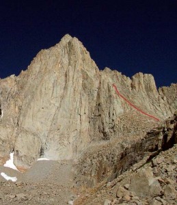
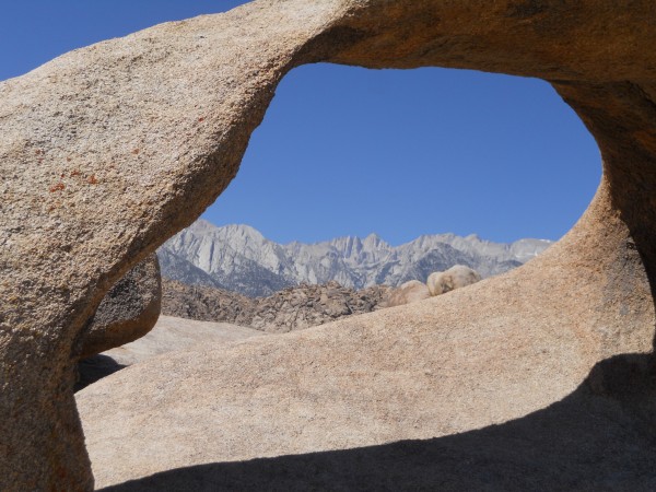
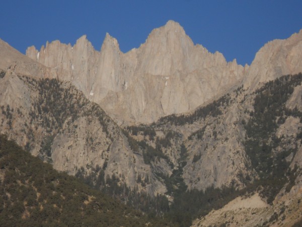
Whitney as seen from Arch Rock, Alabama Hills
Credit: Seamstress
bottom left corner bottom right corner
A friend abruptly quit her job and laid a great temptation before me. Let's climb in Yosemite in June, and name where you want to go later in the summer. Years ago, I had a permit to climb Mt. Whitney, but that went unused as another once in a lifetime event took place. Time to rectify that.

I flew into Reno and drove to Lone Pine. Yes, the campground is 6 miles outside of town. You must turn at the only light in town. Wish I had reviewed that note before darkness fell. I cruised around the campground for some time unable to locate site 42. That is because sites 39 - 43 are not near site 38 and in a day use trail head clearly labelled "no camping". So I poached site 8 for the first night.

Morning arrived, and the right site was located. This was a day to acclimatize from sea level and get the administrative paperwork completed. I was just agonizing about not yet meeting my friends when lo and behold, they walk up to the administrative building at the same time. Gear, permit, partners - check. We are ready to go.
top left corner top right corner
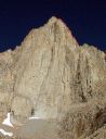
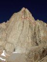
Whitney from the Lone Pine Campground
Credit: Seamstress
bottom left corner bottom right corner
That hot afternoon, rainbows were collected from the stream flowing through the campground, and we feasted on trout. Final preparation was completed.
top left corner top right corner
Upper Boy Scout Lake
Credit: Seamstress
bottom left corner bottom right corner
top left corner top right corner
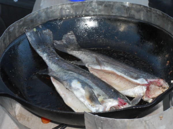
Trout - it's what's for dinner
Credit: Seamstress
bottom left corner bottom right corner
The next morning, we drove up to Whitney Portal. The women insisted on a shower before hitting the trail I tried to explain this to the man. He didn't understand why beginning the trip shiney and clean mattered given we would be sweaty and filthy in short order. 2 against 1, the women prevailed. There was some scoffing at the time I built into the schedule for acclimatizing. I wanted to stop at Upper Boy Scout Lake before moving up, but the younger couple thought that we should get to Iceberg Lake that day and climb the next.

We set off the Whiteney Portal Trail. We checked the first trail to the right, but it didn't match the GPS coordinates that supertopo gave by just a smidge. I began to worry about map datum and GPS settings. Just another 1/4 mile up the trail , a large sign clearly pointed to the North Fork Lone Pine Trail - and I was relieved to still be "on route".

I noticed one common trait on this trail. You must traispe through water before crossing rock or committing to a hard fourth class section with a heavy pack. Perverse. I was delighted with the Smedges which performed admirably. I was somewhat unstable with 60 pounds on my back, almost half of my weight. After making our way up the ledges, we were caught in a snow squall. My friend has Raynaud's Syndrome, so camp was established at Lower Boy Scout Lake to warm her up. It is a great camping spot.
top left corner top right corner
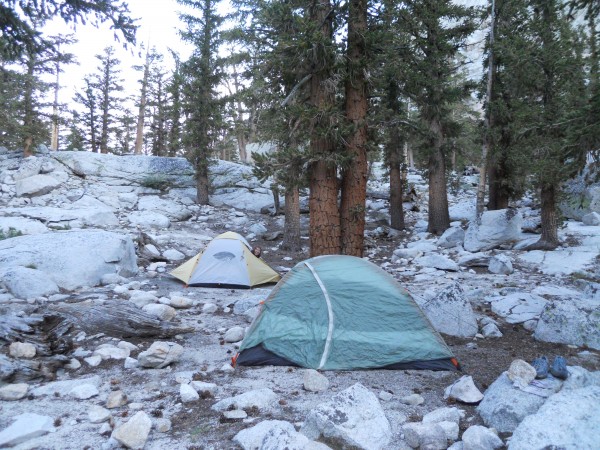
Lower Boy Scout Lake Camp
Credit: Seamstress
bottom left corner bottom right corner
The next day was sunny and bright. We repacked and set off for Upper Boy Scout Lake. Warning - there are cairns high and cairns low. I set off early and went up - after all, we are climbing a mountain. My friends left later and took the low route hugging the vegetation. I patiently waited before the slab and waterfall crossing. Somehow, they slipped by me. Eventually, I gave up and forged ahead to find them at the lake. The redhead was experiencing some vertigo which seemd to be improving as she rested. Another rainbow trout feast was prepared. Obviously we were now going with the schedule that called for acclimatization time.

When we rose the next morning, we decided to just do a short hike up to Iceberg Lake and allow everyone to fully acclimatize before climbing the East Face. Since retreat would involve reversing some of the pitches, we did not think it was wise to go up if a party member was experiencing some dizziness. She seemed fine - except when she turned her head. She seemed to improve throughout the day, and we were hopeful.

We packed for an early morning departure. I noticed that I did not see my car keys as I packed and repacked. Hmmmmm.

It was finally time to climb the East Face. We should have heeded Supertopo's warning and not turned up to Iceberg lake on the steep wet section. We knew what laid ahead of us from the foray the day before. I packed extra socks, plastic bags (Cascade Gaiters), handwarmers to recover from splashing through the waterfall. The breeze had blown throughout the night, and the wet spot was now frozen. We broke out the rope for a little assurance. As soon as I got to the top of the flow, I quickly changed my socks and inserted handwarmers into my shoes. It didn't go as well for my friend. The cold and fear conspired to bring on a major asthma attack. After calming and rewarming her, the decision was made to go back down. Drats, defeated again. I needed to do something productive, so I ran down to our first campsite to search for the misplaced car keys. No luck.
top left corner top right corner
Retreat - go the other way!
Credit: Seamstress
bottom left corner bottom right corner
All night I toyed with the notion of going down one day early to deal with the possible lost car key or run up the Mountaineer's Route by myself to at least touch the summit. As the three of us munched on the pancake mix that had not been raided by the varmits, the redhad indicated that she was still experiencing mild vertigo and thought it best to make no further attempt to climb this trip. Her boyfriend stayed with her. Although it was late, I decided to go up.

The forecast was perfect. We had not seen a cloud in several days, and none were expected. I took off about 9:30 AM. Hopefully there would be no ice on the waterfall or I could find a way around. I am very cautious when alone. I followed the cairns, and they actually led up through a gully, dry and safe. Imagine that.

Above Iceberg Lake, it became more challenging. I now followed the book's instructions. Stay to the left it urged. I guess I went too far left and found myself staring at the Fresh Air Traverse. Glorious. No partner. Major bummer.
top left corner top right corner
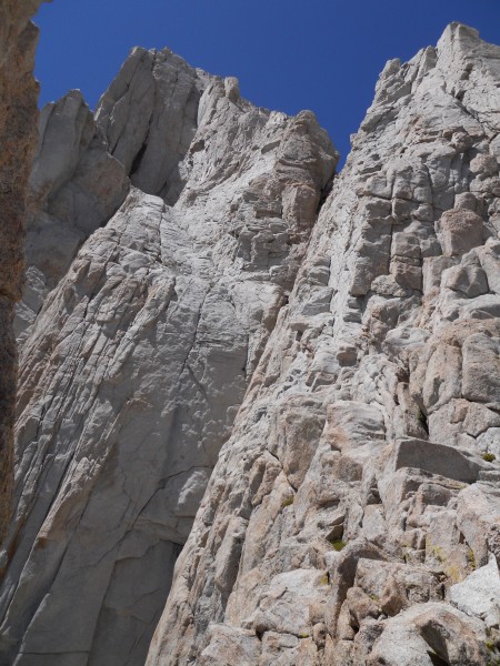
Longing for Fresh Air - no partner, no touch.
Credit: Seamstress
bottom left corner bottom right corner
I downclimbed and spotted a huge cairn. I went towards it and then moved up. This apparently leads to the East Buitrress.
top left corner top right corner
Turn Signal
Turn Signal
Credit: Seamstress
bottom left corner bottom right corner
Again, I went down to the cairn and then traversed over to the right into a disgusting gully. Spying a person coming down, I was now certain that I was on route. At the top of this most disgusting gully, I made the turn left. Now the book says to take the first passage. To a rock climber, any crack looks plausible. As I toyed with what was precisely the best spot to move up, another party dropped into the gully. It was the third crack to the right in the first gully on the left. Got it?
top left corner top right corner
Ugly
Ugly
Credit: Seamstress
bottom left corner bottom right corner
The Mountaineer's Route had some rock hard snow and water in it. The left wall was fourth class, maybe 5.1, and it looked so much more appealing. Up I scrambled, dead ending just once. I poked my head up and over the ridge. The summit was an amazingly flat, wide plateau. It was laaaate, but the weather was perfect without a trace of clouds in the sky. My duaghter had given me "the spot" for Christmas. While I never would have bought this for myself, I decided to activate it and use it for this trip. I like to encourage gifts. I sent out an "I'm OK" message from the summit, signed the register, snapped some pictures, and began to descend. I did not want to forget exactly how I got there!!!
top left corner top right corner
It's official!
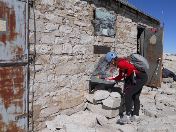
It's official!
Credit: Seamstress
bottom left corner bottom right corner
The descent took longer than I expected, and this was after ascending the same way. For future reference, it is very helpful to be familiar with the descent route prior to climbing the face. I was sharing the gully with another party and great care was necessary to avoid raining debris in the gully. While the gully remained hideous, the landscapes before me were beautiful.
top left corner top right corner
Iceberg Lake
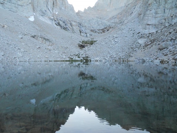
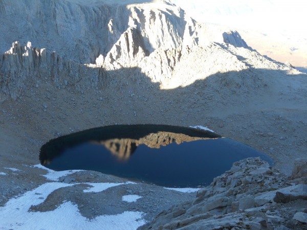
Iceberg Lake
Credit: Seamstress
bottom left corner bottom right corner
The lakes had the most amazing reflections of the surrounding granite walls. Darkness fell when I was at about 12,000', and I picked my way down the last slope into camp by headlamp. My friends were concerned when I wasn't back before dark, and they were preparing to look for me. Leftover cold spaghetti in a jar tasted mighty good.

The next morning, I gave away everything I did not need to others camping in the vicinity, ate as much as I could, and begain the trip down. We were disappointed not to climb the East Face, but the day was most marred by the stench of the wag bags. I don't know how they can claim that it deoderizes. At our breaks, we moved AWAY from the packs. I can't tell you what I looked forward to most - a shower or getting rid of that wag bag. A better system is needed!

I checked in the store for lost car keys. Yes, they had a key. The clouds liftd and birds sang. It was a Honda key, and the world was dark again. I dropped my pack and ran 1/2 mile down the road to where the car was parked. Peering inside, I thought I saw the key on top of the rope bag. At Whitney Portal, I only got cell phone reception at the store, specifically the trail side of the store. Many calls were made before the rental car company's road side assistance located a serivce to open the car. This angel drove 88 miles one way to open the car, a bargain at $43.

Lessons learned:

1) Keep track of car key at all times
2) Follow approach notes
3) Make sure your partners are training even if they are 20 years younger than you.
4) Bring a hard, sealed container for your wag bag
5) Bring a fishing pole and take less food
6) A camera is essnetial equipment
7) Dry feet are happy feet


  Trip Report Views: 7,496
Seamstress
About the Author
Seamstress is a trad climber from Yacolt, WA.

Comments
Plaidman

Trad climber
West Slope of Powell Butte, Portland, Oregon, USA
  Aug 17, 2010 - 02:11pm PT
Great trip report. I was right there with ya. Wish I really had been. Thanks for sharing.

I know where Yacolt is. I have even been there several times.

Plaidman
Seamstress

Trad climber
Yacolt, WA
Author's Reply  Aug 17, 2010 - 02:23pm PT
It is the "place where the evil spirits dwell"!! I also see your posts on Cascade Climbers..
Plaidman

Trad climber
West Slope of Powell Butte, Portland, Oregon, USA
  Aug 17, 2010 - 02:31pm PT
Check out my blog at:
blog.oregonlive.com/climbing
nutjob

Sport climber
Almost to Hollywood, Baby!
  Aug 17, 2010 - 05:14pm PT
Sorry you didn't get to scratch the itch for more techie climbing, but sounds like you had fun anyways! Maybe the wagbag is the only thing that would make me wait til I'm in good enough shape for car-to-car.
Mungeclimber

Trad climber
Nothing creative to say
  Aug 18, 2010 - 01:40am PT
sealable dry bag for the wag output? hard case will be heavy.

rhyang

climber
SJC
  Aug 18, 2010 - 10:01am PT
Nice work !
Brokedownclimber

Trad climber
Douglas, WY
  Aug 18, 2010 - 10:19am PT
A very nice, enjoyable TR! Thanks!
georgiegirl

Sport climber
Heaven
  Aug 18, 2010 - 11:45am PT
Great TR! Way to bag the summit regardless of your partners' situation. Hopefully you will be able to climb the east face another trip!
Seamstress

Trad climber
Yacolt, WA
Author's Reply  Aug 18, 2010 - 01:13pm PT
It's not easy for a little old lady to line up partners for such adventures. The big and strong get impatient with the heavy pack struggles (no sympathy for carrying nearly half your weight). I also want to do my share of the leading, especially of the traverses because I hate traverses. Someday better come soon!!!
Zander

climber
  Aug 19, 2010 - 12:28am PT
Nice Seamstress,
My wife, Wendy and I did the Mountaineers route a few years ago. It was a fun time. I think you must have really wanted to climb the East Face, which it's Siren's call kept getting you off route!! . Thanks for posting. Climb On
Zander
Ezra Ellis

Trad climber
North wet, and Da souf
  Aug 19, 2010 - 10:08am PT
Nice!
Karen

Trad climber
Prescott, AZ ~
  Aug 19, 2010 - 12:01pm PT
Gotta love those wag bags! Last year my daughter, her friend and I did Whitney, we brought along trash compacter bags to put the wag bags into, that helped some. Those wag bags became quite a topic of amusement between the three of us.

Great trip report!!!!
426

climber
  Aug 19, 2010 - 12:28pm PT
Neat. Great shot of iceberg. What did you catch the trout on?

I always like to take a little cornmeal "mix" and hit the trout pan fried.
bluering

Trad climber
Santa Clara, CA
  Aug 19, 2010 - 12:50pm PT
Nice write up! Despite not getting your route, you did summit at least. Nice job!!!!

I wanna know what you caught the trout on too.
mooser

Trad climber
seattle
  Aug 19, 2010 - 12:55pm PT
I really like your writing style. Very engaging!
Sascha

climber
Oakland, CA
  Aug 19, 2010 - 01:22pm PT
Nice TR, seamstress! Thank you - it put me right back there... Good job executing the Mountaineer's Route solo in fine style.

My advice on packing gear up to Whitney: if you can afford it, hire a porter and carry half the weight. Also, I learned that hiking poles make a big difference.

And on car keys: I always stash mine at the car. I figure the chances of someone stealing my car, while not zero, are much smaller than the chances of me losing the key!
Seamstress

Trad climber
Yacolt, WA
Author's Reply  Aug 19, 2010 - 04:49pm PT
The trout bit on everything and anything. We had cheapie small flies on a spinner reel. I didn't see what the hatch was, and the fish seemed easily fooled. My friend never fished before and caught two in ten minutes. I only wish the steelhead and salmon here were so eager to jump into the pan. A little seasoned salt, pam, and the fish deboned themselves. Now if we could only do something about the cleaning part.......

All week, the water was like glass. The reflections off all the lakes created great photos.

It seems greedy to go back to get the routes since conditions probably could not be more perfect.

My timing must have been very fortunate as I did not see a single wag bag strewn about. I put mine in a baggie and a stuff sack and still wanted to be well away from the pack. I soaked that stuff sack with vinegar before washing to remove the odor.
Go
Mt. Whitney - Mountaineer's Route 3rd class - High Sierra, California USA. Click to Enlarge
The route disappears behind the ridge and follows the gully to the summit.
Photo: Chris McNamara
Other Routes on Mt. Whitney
Mt. Whitney - East Buttress 5.7 - High Sierra, California USA. Click for details.
East Buttress, 5.7
Mt. Whitney
  • 1
  • 2
  • 3
  • 4
  • 5

The route as seen from Iceberg Lake.
Mt. Whitney - East Face 5.7 - High Sierra, California USA. Click for details.
East Face, 5.7
Mt. Whitney
  • 1
  • 2
  • 3
  • 4
  • 5

The route as seen from Iceberg Lake.