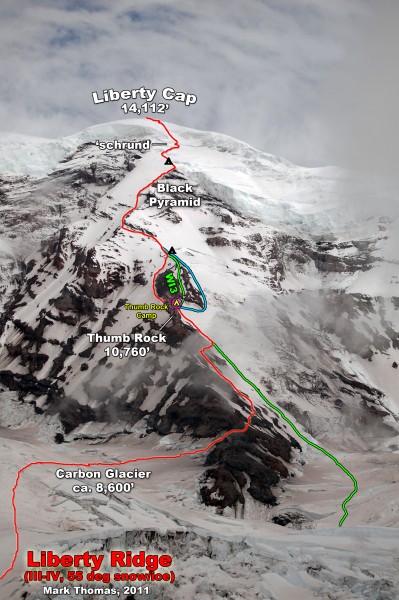
July 15-18, 2011
 Credit: PellucidWombat |
||
 Credit: PellucidWombat |
||
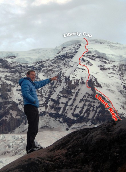
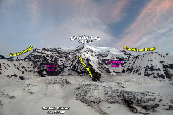
This July I climbed Liberty Ridge on Mt Rainier with Eric, a local Washington climber that I had met on CascadeClimbers.com. Despite having great weather in late June, the Pacific Northwest was suffering from lingering winter weather in mid-July, and winter conditions persisted on many routes in the Cascades. Since I was only in town for two weeks, I was willing to put up with a mediocre forecast in order to get up on the route and hopefully catch a weather window. Though we had originally planned to do the climb Thursday-Saturday, the NOAA point forecast got us to shift the climb to Friday-Sunday so that we'd have the best weather on Sunday. Friday morning the forecast called for a good chance of rain & snow the first two days, and "Mostly Sunny" for Sunday and beyond. Two days of putting up with rain & snow until weather cleared or we popped above the clouds seemed an all right price to pay to catch the weather window Sunday.
To be safe, we would also carry enough food & fuel for 5 days for the 3 day climb in case weather delayed us on the climb. We also brought a GPS with pre-recorded waypoints for the approach, climb, and descent. This proved valuable on the climb.
Friday - The Weather Ain't That Bad!
Despite the 'bad' forecast, it was actually pretty clear on Mt Rainier.
 Credit: PellucidWombat |
||
 Credit: PellucidWombat |
||
 Credit: PellucidWombat |
||
The only source of moisture on our gear was from perspiration this day as it felt hot & humid.
 Credit: PellucidWombat |
||
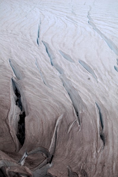
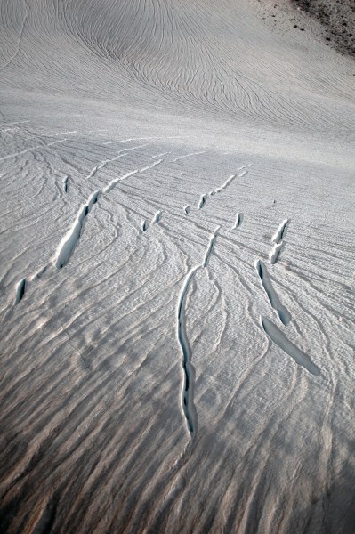
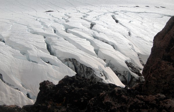
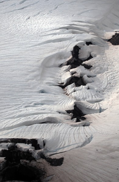
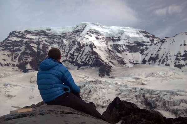
We made camp at about 7,400' on lower Curtis Ridge and enjoyed some rock slabs that were perfect for lounging and taking in the views. Since we expected it to be cloudy that night, I decided to make use of the weight of the DSLR I hauled in and took artsy photos of the Carbon Glacier.
 Credit: PellucidWombat |
||
 Credit: PellucidWombat |
||
 Credit: PellucidWombat |
||
 Credit: PellucidWombat |
||
 Credit: PellucidWombat |
||
 Credit: PellucidWombat |
||
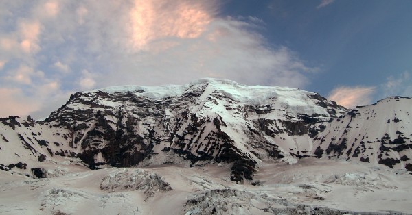
As the evening wore on the clouds parted and we were fortunate enough to get a clear view of the north side of Mt Rainier. Considering the forecast, I had been prepared to miss out on this, so it was a great surprise!
 Credit: PellucidWombat |
||
Thar She Blows!
 Credit: PellucidWombat |
||
 Credit: PellucidWombat |
||
Saturday - Should We Keep Climbing?
 Credit: PellucidWombat |
||
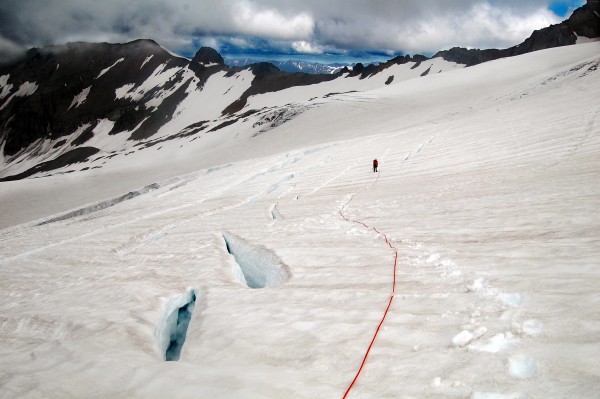
We started climbing under a light rain, but fortunately I never needed to use the waypoints I had put into my GPS. Clouds were either below us or above us the entire time, so visibility was fine on the Carbon Glacier.
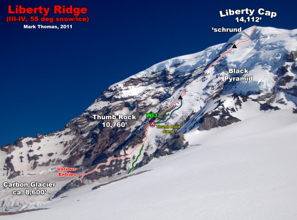
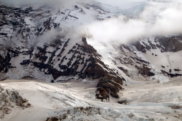
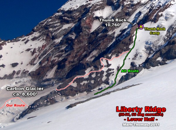
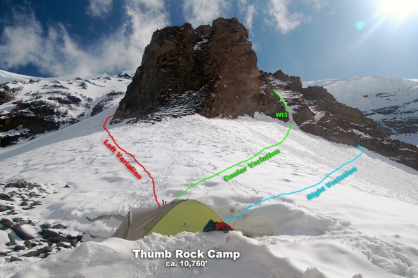
Rain turned to snow as we neared the toe. We had hoped to take the direct variation to Thumb Rock on the west side, but we couldn't find a way through the crevasses and were forced to endure about a pitch of unprotectable skice and slush mixed into a vertical gravel slurry to gain the toe from the east.
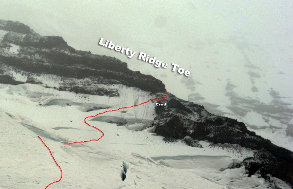 Credit: PellucidWombat |
||
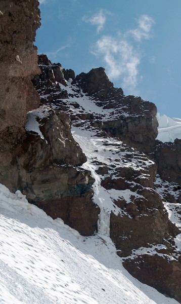
Fortunately as we wrapped around the sketch factor decreased, though for about half of the ascent we had shallow snow mixed in with the loose rock. As we neared Thumb Rock I came across one chute that was dribbling out rocks every minute or so. I made sure to sprint across this section!
 Credit: PellucidWombat |
||
 Credit: PellucidWombat |
||
 Credit: PellucidWombat |
||
The plan for the next day was to start climbing by 3am to get us over the Cap and down to the TH at a respectable hour, but when Eric checked the updated forecast on his phone, he saw that our "Mostly Sunny" weather window had changed to "80% chance of snow, 1-3" @ 13k'".
Yikes!
We were tempted to pack up camp then and there and just keep climbing while it was still clear and sunny, but we were tired, relaxed, and decided that since the weather was forecast to move in later in the morning, we'd wake at midnight and be climbing shortly after 1am to beat the weather.
Sunday - We Should Have Kept Climbing
 Credit: PellucidWombat |
||
Climbing was great under a bright moon, and although we climbed in darkness, we had nice views of Seattle and the north side of Mt Rainier as we ascended.
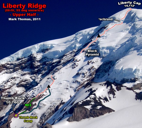
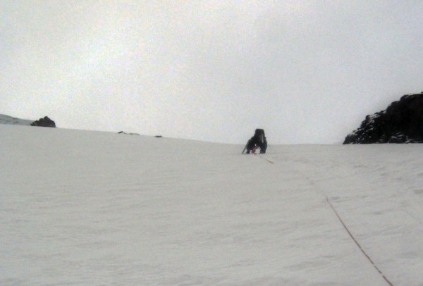
As we got higher we encountered more early-season conditions as the hard neve/ice often had a layer of fresh snow on top. Sometimes we could crampon, but often we were kicking steps calf deep and sometimes knee deep in the snow to make steps or reach purchase in the ice beneath. This was hard work and slowed our ascent more than expected. We took turns breaking trail, swinging leads about 6 times on the route.
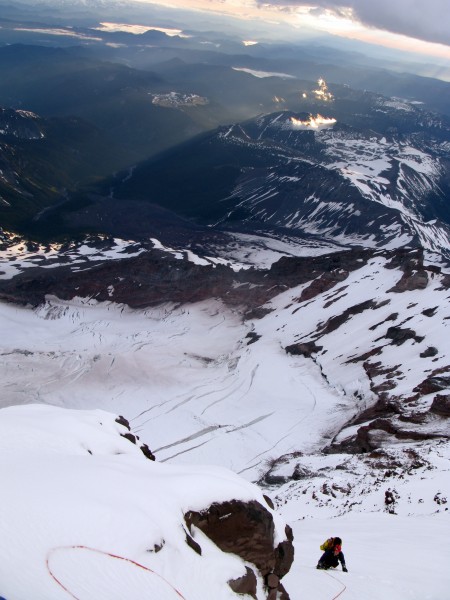
The weather was still clear as the sun rose shortly after we rounded the Black Pyramid to ascend the slopes above Willis Wall. I took my sole climbing picture of the day then, as by the time we reached the top of the Black Pyramid, the storm had already broken.
 Credit: PellucidWombat |
||
 Credit: PellucidWombat |
||
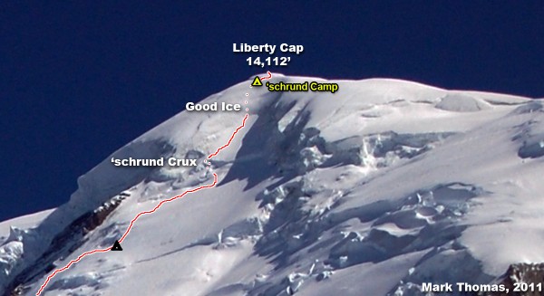
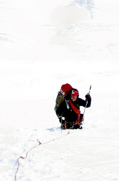
We moved at a snail's pace as we tired from the elevation and soft snow, but the snow kept getting softer and deeper. As I traversed over to the bergschrund crux, I was often digging through waist deep snow, right up to the ice pitch. By this time it was snowing hard and the wind was blowing around 30-40 mph. The ice pitch had a continual dumping of windblown snow that was sluffing off the slopes above. I got thoroughly drenched from these pervasive ice crystals as I climbed 1 pitch of ice through the whiteout, stopping every time snow poured down on me to brace myself and cinch up my hood. This pitch normally would have been pretty easy but conditions definitely added to the stress factor!
Eric took the next trailbreaking lead and found another nice pitch of sustained 40 degree ice. Though exhausted at this point, I welcomed the ice for the break it provided from the soft snow. Plus it was fun! I finished another pitch of ice to the top of the route.
Unfortunately here the wind gusts picked up and visibility dropped to near zero. We had difficulty reaching the top of the Cap as a large bergschrund stopped us less than 100 ft from the top. Going left, it grew larger, so we backtracked to the right and end-ran it and were shortly on top of Liberty Cap.
The problem at this point was that we could barely see the snow 1 or 2 steps in front of us. Despite having our waypoints for descent set in the GPS, that only helped us for the larger scale routefinding. We realized that we could easily walk off a cliff or into a crevasse with the visibility as bad as it was. We were both thoroughly soaked and becoming mildly hypothermic. I was covered in rime ice, already had the "umbles" and was beginning to get the "stumbles" and both Eric and I had been shivering non-stop for the past 3 or 4 hours.
The last forecast we had seen showed the weather to dissipate Monday, so we decided it was best to set up shelter on the Cap to get warm & rested, and attempt to descend once visibility improved a bit more.
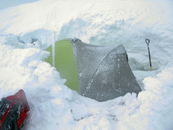
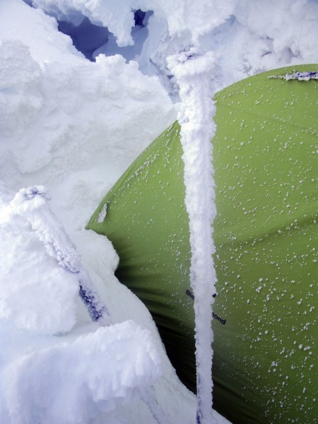
We dug a platform into the bergschrund wall that we had end-run and I built up some hardy wind walls. Despite the howling wind, the BD First Light we were using was pretty calm, and our biggest complaint was being buried from snow drifting over our tent. Eric took initiative and shoveled snow off the tent a couple of times throughout the night.
Everything in our packs was saturated, including our sleeping bags. Luckily neither of us was using down loft! We melted more water and spent the night gradually rewarming as we slept in our soggy bags and clothes.
 Credit: PellucidWombat |
||
Monday - The Sorry Soggy Slog
 Credit: PellucidWombat |
||
 Credit: PellucidWombat |
||
Hooray! We could now see about 20-50 feet! We were up early, packed up camp, and began navigating to our waypoints to bypass the Columbia Crest and GET DOWN. It felt like we were going pretty slow, but we actually made pretty decent time through the 50 mph gusts and whiteout as we found the right way off the Cap and around the Crest.
There was still tension in the air as we climbed, as all of the fresh windblown snow hid the crevasses pretty well. I punched into two as we descended the Cap. The first one was large enough that I stopped my fall by hooking the far side with my tool and stemming my legs. I ratcheted back up, rolled onto the near edge, then jumped across to keep up the pace. Barely a setback at this point.
 Credit: PellucidWombat |
||
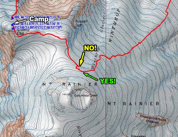
We did get held up briefly in the seracs atop the Winthrop Glacier, as apparently you can't traverse straight over to the Emmons from the height of the saddle connecting the Cap & Crest (oops). For future reference, you still need to ascend a couple hundred feet up the Crest to bypass the seracs & 'schrund before dropping back town towards the Emmons Glacier.
 Credit: PellucidWombat |
||
Gradually the skies cleared and we found the Emmons Glacier wands. I put away the GPS, put my brain into autopilot mode (with the crevasse-search feature still engaged), and at last began a relaxed descent. I finally stopped shivering as we got more sunshine through the blowing clouds. Sadly the Inter-Glacier was too slushy for any real glissading, but we made good time rushing down the trail as thoughts of Doritos and beer in the car kept me at a steady 3mph clip.
 Credit: PellucidWombat |
||
Despite being thoroughly trashed, I headed back to Mt Rainier the following weekend to climb Ptarmigan Ridge, a longer, harder, and arguably more classic route than Liberty Ridge. The weather forecast was much better for this climb, but Liberty Cap wasn't done with me yet (Liberty Cap Beating #2: Ptarmigan Ridge)
Gear Notes:
We brought 4 screws & 2 pickets between us. This was more than sufficient.
Approach Notes:
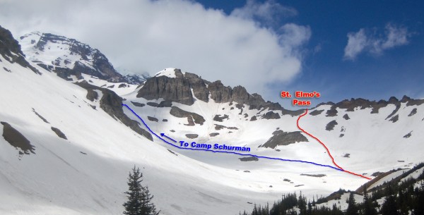
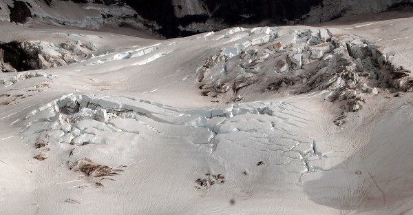
The Carbon Glacier was getting more broken up when we crossed it. We had to do a large end run to the far west side of the glacier at the beginning, and we couldn't find a route around the toe of Liberty Ridge.
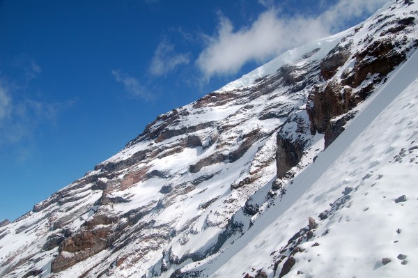
The rock on Liberty Ridge's toe was very melted out and best avoided if possible. It was some of the most dangerously loose rock I have ever climbed. Rocks were also falling off the ridge crest regularly just below Thumb Rock.
Just in case I didn't put in enough photos in this TR, you can see more of them here. :-P
Personal Website