Astroman, Washington Column 5.11c |
||
Yosemite Valley, California USA | ||
|
Google Maps Overview
|
|
|
The GPS coordinates for this route are shown below. See the GPS Marker Legend at right for details on each marker. Click on the Marker to see the actual GPS coordinates. Approach
This approach is about a mile long, takes 40 minutes, and gains 1,000 feet in elevation. From the Ahwahnee Hotel parking area, hike east along a dirt road (through the valet parking area) until reaching the bike path. Continue east (left) for about 0.5 mile to a point where the bike path and horse trail (on the left) nearly meet. At the point where the bike path turns right, head left, cross the horse path, and continue into the trees. (Dont worry if you miss this trailjust walk up the hill, meet the wall, and walk right.) A climbers trail winds up to the base of a wall and then continues up and right to the base of the East Face of Washington Column.Descent
From the top of Washington Column there are three descent options:North Dome Gully Though by no means enjoyable, this is the best and fastest descent option. Allow 1-2 hours if experienced with the descent and 2-4 hours if it is your first time. Do not attempt it at night unless youre familiar with the descent. For this descent, refer to the North Dome Gully Descent description. Royal Arches Rappels This option depends on your ability to find the top of the Royal Arches route. This is a difficult task unless you have already climbed the Royal Arches. This option takes 2-4 hours. North Dome Trail This is the longest and most grueling descent but may be the best option if you are descending in a storm and are unfamiliar with the North Dome Gully. For this descent, walk northwest until you pick up the North Dome Trail. Follow this for about 8 miles until you reach Camp 4. |
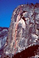 Photo: Chris McNamara
|
Home | Climbing Areas | Free
Topos | Guidebooks | Route
Beta | Forum | Trip Reports |
Photos | Articles
Links | Terms | Privacy | FAQ | Contact
| About Us
Climbing Areas
Rock Climbing Yosemite |
Big Wall Rock Climbing Yosemite |
Rock Climbing Tuolumne |
Rock Climbing Sierra
Rock Climbing Red Rocks |
Rock Climbing Southwest |
Rock Climbing Zion |
Rock Climbing Tahoe |
Climbing Alaska
All trademarks property of their respective owners
How can we improve SuperTopo? Got feedback?
![]() Let us know!
Let us know!
Climbing is dangerous. Climb at your own risk.