Steck Salathe, Sentinel Rock 5.9 |
||
Yosemite Valley, California USA | ||
|
Google Maps Overview
|
|
|
The GPS coordinates for this route are shown below. See the GPS Marker Legend at right for details on each marker. Click on the Marker to see the actual GPS coordinates. Approach
This 1.5-mile-long approach gains about 1,500 feet in elevation. Park at the paved pullouts for the Four Mile Trail (1.8 miles from El Cap Meadow) and hike up the trail about 0.5 mile to a creek crossing (dry in late season). Just before the creek crossing, leave the trail and hike up the talus slope. Cairns mark the trail as it switchbacks up the talus. At a point near the base of the rock, the trail splits; hike up and right toward the large ramp. Continue up this ramp and slightly right until you reach a trail contouring west (right). This trail traverses a ledge and passes trees to another ramp leading up and right. Continue several hundred feet up the talus... GET Yosemite Valley Free Climbs and read the rest this approach as well beta for over 200 other classic Yosemite routes.Descent
From the top of Sentinel Rock, hike north and east following a trail through the bushes and over boulders into the gully. Continue down and eastward through the gully, being careful of loose rock. Once down the gully, cross a creek and continue over slabs down and right. Scramble down the slabs past bushes and trees. Once at the base of the slabs, hike along the right side of the trees and down a bit (with more slabs on the right). Cut left through the trees and contour over to the point where the approach trail splits. Follow the trail back down the talus to the Four Mile Trail and return to the trailhead. |
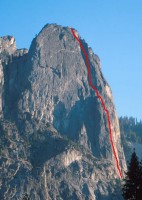 Photo: Randy Spurrier
|
Home | Climbing Areas | Free
Topos | Guidebooks | Route
Beta | Forum | Trip Reports |
Photos | Articles
Links | Terms | Privacy | FAQ | Contact
| About Us
Climbing Areas
Rock Climbing Yosemite |
Big Wall Rock Climbing Yosemite |
Rock Climbing Tuolumne |
Rock Climbing Sierra
Rock Climbing Red Rocks |
Rock Climbing Southwest |
Rock Climbing Zion |
Rock Climbing Tahoe |
Climbing Alaska
All trademarks property of their respective owners
How can we improve SuperTopo? Got feedback?
![]() Let us know!
Let us know!
Climbing is dangerous. Climb at your own risk.