Dark Shadows, Mescalito North 5.8 |
||
Red Rocks, Nevada USA | ||
|
Google Maps Overview
|
|
|
A map of the general Red Rocks, Nevada USA area is shown below. No GPS coordinates for this specific route are available at this time. Approach
The Pine Creek parking lot is most of the way around the loop road. Popular with both climbers and hikers, the rush is on as soon as the gate opens and the lot can fill early. The trail is large, well-worn, and easy to follow until almost at Mescalito, where one branch dives down left into the creek bed (almost always completely dry). While it is possible to thrash along the streambed of the right branch, it is much easier to gain the climbers trail on the right bench. Just as a line of 40-foot-tall red cliffs seems to force you into the stream, climb up the bench and around a prominent huge boulder. A beautiful trail leads from here straight to Dark Shadows. (Thanks Access Fund volunteers!) Dark Shadows begins on a rock above a 6-foot waterfall between two pools of water. Descent
Rap the routes, and reverse the approach. Please do not travel in the wash, the main trail was built specifically to reduce traffic in this sensitive riparian habitat, one of the few in Red Rocks which nearly always has flowing water.
|
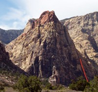 Photo: Greg Barnes
|
Home | Climbing Areas | Free
Topos | Guidebooks | Route
Beta | Forum | Trip Reports |
Photos | Articles
Links | Terms | Privacy | FAQ | Contact
| About Us
Climbing Areas
Rock Climbing Yosemite |
Big Wall Rock Climbing Yosemite |
Rock Climbing Tuolumne |
Rock Climbing Sierra
Rock Climbing Red Rocks |
Rock Climbing Southwest |
Rock Climbing Zion |
Rock Climbing Tahoe |
Climbing Alaska
All trademarks property of their respective owners
How can we improve SuperTopo? Got feedback?
![]() Let us know!
Let us know!
Climbing is dangerous. Climb at your own risk.